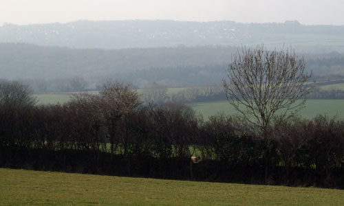
The deep, wooded cleft of the Plym valley is surrounded by intricate pastoral farmland punctuated with hedgerows. It forms a distinctive feature within the setting of Plymouth, and contrasts with both the moorland of Dartmoor above, and the urban mass of Plymouth below. The steep-sided, wooded valleys have a strong sense of enclosure and intimacy, feeling like a ‘world of their own’ and far removed from the adjacent city. Dark coniferous plantations contrast with the seasonally-changing colours of the ancient deciduous woodlands which cloak the valley sides. There is a strong sense of history, with a prehistoric hillfort, historic parklands, manor houses, farms and industrial heritage all visible within the landscape.
- Context
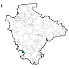
 This relatively small area (including the Plym valley) is located to the north-east of Plymouth and makes an important contribution to the setting of the city. To the north-west is the more open land of Roborough Down, within the River Tavy Middle Valley area. To the north-east is a more gradual transition into the higher land of Southern Dartmoor and Fringes. In the south-east is a small area of transition into the lower-lying Plymouth and Modbury Farmlands. The area’s western and southern boundaries are defined by the edge of the city of Plymouth.
 - Constituent Landscape Character Types
Constituent LCTs:3A: Upper Farmed and Wooded Valley Slopes.
Part of NCA:151: South Devon - Distinctive Characteristics
- Underlying geology predominantly comprising Devonian rocks (mudstone and slate with limestone and sandstone) with occasional intrusions of later igneous granite.
- Undulating landform, containing the steep-sided, V-shaped valleys of the river Plym and its tributaries.
- River Plym flowing north-south through the area, fed by several spring-fed streams rising on the edge of Dartmoor.
- A very well-wooded landscape, containing extensive areas of deciduous and coniferous woodland on valley sides, plus numerous smaller woodlands, copses and hedgerow trees.
- Medium-poor quality soils, mainly supporting pasture with some pockets of arable land use.
- Fields generally small to medium size and semi-regular in shape; some surviving medieval enclosures and ‘Barton’ fields (laid out between the 15th and 18th centuries) in the north, around Roborough.
- Field boundaries generally wide earth banks with low, species-rich hedgerows and hedgerow trees.
- Semi-natural habitats including extensive areas of woodlands, valley-floor wetlands, and unimproved or semi-improved grasslands.
- Strong sense of time-depth due to prominent Iron Age hillfort in the central part of the area and extensive areas of historic parkland.
- Remains of former industrial and mineral workings throughout the area; mineral extraction works still active on its peripheries.
- Sparse settlement pattern of isolated farms, hamlets and occasional large houses; dwellings often constructed of red brick or stone, with stone farm buildings.
- Farms and hamlets linked by narrow, steep and twisting lanes, often lined with high hedgebanks; lanes generally on higher ground, with limited access to river valleys.
- Landform and vegetation creating a generally enclosed landscape, contrasting with the open moorland of Dartmoor above and in places affording spectacular views up and down the Plym valley.
Evaluation
- Special Qualities and Features:
- High scenic quality due to the combination of landform, woodland and water, with the moorland skyline of Dartmoor to the north and east giving the area a strong sense of place.
- Important setting both to the National Park and to Plymouth, with woodland screening views of Plymouth from within the area and softening views of the built-up area when seen from Dartmoor.
- Sense of peace, remoteness and secrecy within deep wooded valleys which is particularly unusual given the proximity of Plymouth.
- Extensive areas of ancient woodland, generally in river valleys, sometimes abutting the urban edge.
- Numerous and extensive CWSs, mostly broadleaved woodland sites, but also other habitats including plantation, unimproved neutral grassland and bracken-covered slopes.
- Several RIGS sites in cuttings, quarries and mines, demonstrating geological formations and igneous processes including dykes, sills and breccia.
- Many SMs, including Boringdon Camp (Iron Age hillfort overlooking Plymouth and the coast); Newnham Park (late-medieval deer park and rabbit warren); Boringdon Park (medieval fishponds, post-medieval deer park, 18th century triumphal arch and 19th century lead mine).
- Historic farms, manor houses, bridges and industrial remains throughout the area.
- West Devon Way recreational route following the Plym valley north-south through the area linking city to moor; extensive accessible woodland/plantation at Common Wood and Cann Wood and Erme-Plym cycle trail.
Forces for Change and Their Landscape Implications:
- Past and Current
- Urban expansion of Plymouth, including housing estates with roofscapes that do not respect the grain of the landscape, and prominent buildings such as industrial estates immediately adjacent to the area.
- Development around Roborough visible from higher parts of the area, affecting unspoilt character.
- Noise and light pollution from Plymouth and major roads.
- Active and disused china clay workings and associated lakes creating a highly-visible white ‘lunar landscape’ within and just beyond the edges of the area.
- Occasional examples of visually-intrusive development such as pylons and the military camp at Bickleigh, locally affecting the character of the landscape.
- Urban fringe influences (e.g. golf course; piecemeal informal development; pony paddocks; highways works and signage) potentially gradually eroding of the character and quality of the landscape.
- Neglect of hedgerows, trees, agricultural land and farm buildings (partly as a result of long-term agricultural decline), potentially increasing the ‘urban fringe’ character of the area.
- Past agricultural changes (e.g. wetland drainage, increased fertilizer use etc.), affecting character.
- Past replanting of deciduous woodlands with coniferous plantation, changing the valleys’ character.
- Invasive water-borne weeds (e.g. knotweed, Himalayan balsam) potentially affecting native riparian vegetation and habitats.
- Proximity to urban population of Plymouth and subsequent recreational pressures.
- Recreational pressures due to close proximity of Plymouth.
- Future
- Pressure for urban expansion of Plymouth, potentially squeezing woodland and farmland landscapes, and also becoming increasingly visually intrusive as it expands further up valley sides.
- Threatened loss of woodland and trees as a result of new pests and diseases (e.g. Phytophthora), potentially resulting in the loss of a key element of the landscape.
- Tree loss due to increased magnitude and frequency of storm events due to climate change.
- Uncertainly over future levels of agricultural grants and funding, potentially affecting livestock numbers and maintenance of landscape features such as hedgerows and historic farm buildings.
- Change in seasonal weather patterns (e.g. increased summer droughts and winter flooding) potentially leading to loss of drought- and water-intolerant species and changing agricultural practices.
- Demand for renewable energy schemes, including hydro-electricity generation on larger rivers and streams, wind turbines on exposed land, solar arrays and growth of biomass crops.
- Potential demand for new reservoirs to supply water to growing urban populations.
- Demand for new quarries, particularly for aggregate and local building stone
Strategy
- Overall Strategy:
To protect the landscape’s high scenic quality and wooded character, and to protect and enhance the settings to Dartmoor National Park and the city of Plymouth. Woodland and plantation is well-managed and accessible, but the sense of remoteness within the wooded valleys is retained. Agricultural land is well-managed and habitats and landscape features are in good condition, resisting ‘urban fringe’ influences. Historic landscapes are protected. Any future development of Plymouth and surrounding settlements is carefully sited and designed to minimise its impact. Recreational links between city and countryside are encouraged.
Guidelines:
- Protect
- Protect the settings of the city of Plymouth and Dartmoor National Park through the retention and enhancement of the area’s wooded character and distinctive topography.
- Protect the landscape’s pattern of hedgerows, hedgebanks and hedgerow trees.
- Protect the sense of remoteness and isolation within valleys, resisting development which would compromise these qualities.
- Protect archaeological and historic sites, including industrial sites, providing sensitive interpretation where appropriate.
- Protect the area’s sparse settlement pattern, ensuring that any new development is appropriate in terms of scale, form, style and materials.
- Protect historic lanes and tracks and their associated hedgebanks, resisting unsympathetic signage or highways measures.
- Manage
- Manage woodland using traditional techniques such as coppicing and grazing to maximise age and species diversity and diversity of ground flora; encourage public access to woodland whilst minimizing the spread of infectious tree diseases.
- Manage plantations as a sustainable source of timber and wood fuel, increasing their biodiversity and potentially their role in recreation.
- Manage agricultural land, keeping hedgerows and other features in good repair through hedge laying and regular management, encouraging biodiversity, and resisting the diffuse, ‘creeping’ urban fringe influences on landscape quality.
- Manage parkland, protecting historic features and replacing mature parkland trees to ensure their continued presence within the landscape.
- Manage river corridors to enhance their biodiversity; control and if possible eradicate any invasive water-borne weeds.
- Manage semi-natural grassland and bracken slopes through locally-appropriate levels of grazing.
- Manage and encourage recreation within the landscape, achieving a good balance between recreation and conservation objectives.
- Plan
- Plan to use green infrastructure to provide a framework for any future development of Plymouth and surrounding settlements, minimising the impacts of development and enhancing links between city and countryside.
- Plan to restore and screen china-clay works to reduce their visual impact within the landscape and to enhance their biodiversity value.
- Plan to reduce light pollution from Plymouth and from major roads.
- Plan to create and link areas of semi-natural habitat (including woodland) to enhance their biodiversity value and increase their resilience to climate change.
- Plan to revert coniferous plantation to deciduous woodland on maturity and felling.
- Plan to explore opportunities for hydro-power generation in suitable sites.