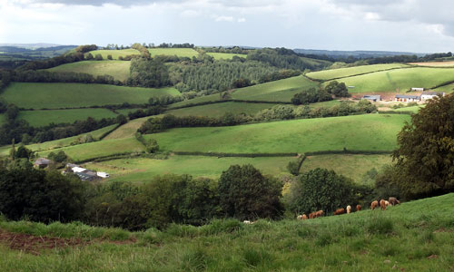
This is a remote and quiet landscape with few through-routes, and is rarely visited by non-locals, giving it a remote, peaceful, timeless quality. Steep lanes run between high hedgebanks rich with colourful flowers. The flat hilltops have a sense of airy spaciousness, with long views towards the Blackdowns to the south and east, and an almost aerial aspect over the lush, deep green woodlands of the Exe valley to the west. In contrast to the open hilltops, the valleys feel enclosed and secretive. In the south, the historic parkland of Knightshayes Court adds seasonal colour and exotic species to this pastoral Devon landscape.
- Context
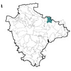
 This character area is located to the north-east of Tiverton, and consists of a series of flat-topped hills interspersed with valleys. To the north is a gradual transition to the higher land of the Exmoor Fringe. To the east is the Somerset border, although the character of the landscape continues beyond it. To the south is a clear fall in height to the Culm Valley Lowlands, and to the west an abrupt drop into the Exe Valley.
 - Constituent Landscape Character Types
Constituent LCTs: 1E: Wooded Ridges and Hilltops, 3A: Upper Farmed and Wooded Valley Slopes, 3B: Lower Rolling Farmed and Settled Valley Slopes, 3E: Lowland Plains, 3H: Secluded Valleys Part of NCA: 148: Devon Redlands - Distinctive Characteristics
- Complex underlying geology at the boundary between the Culm Measures (in the central part of the area) and the older mudstones and sandstones of Exmoor (in the far north of the area), with a band of limestone running east-west between; red Permian sandstone underlies the southern part of the area.
- Landform of high, flat-topped hills with convex slopes, interspersed with slightly lower, more undulating land, often formed by small rivers and tributaries.
- Occasional more marked river valleys – including the River Lowman and Town Leat – flowing southwards; wider valley of Shillingford Vale running east-west across the northern part of the area.
- Trees and extensive broadleaved and coniferous woodland in deepest valleys, and in small blocks on the sides of shallower valleys throughout the area; occasional isolated beech plantations in higher areas.
- A mixture of arable and pastoral farming in upland areas on predominantly medium-quality soils; pastoral farming on valley bottoms and sides.
- Large, often regular fields on hill tops, with closely-trimmed beech and holly hedgerows; valley fields smaller and less regular in shape.
- Woodlands and occasional streamside wetlands providing semi-natural habitats, with numerous surviving orchards also of value to wildlife.
- Huntsham Castle pre-historic hillfort occupying a prominent position within the landscape and adding to the sense of time-depth.
- Parkland and gardens associated with Knightshayes Hall, Hockworthy Court and Holcombe Court contributing an estate influence on landscape character and provision of wildlife habitat.
- Settlement consisting primarily of scattered farms, often with large modern barns which are visually prominent in some upland areas; occasional small villages with square-towered churches situated on lower land, especially in the peripheries of the area.
- Local vernacular of cob, stone and thatch construction found in houses and agricultural buildings such as linhays and barns.
- Settlements connected by a network of steep, narrow lanes, often running along ridge-tops (suggesting considerable antiquity) and containing relatively little traffic.
- An area of high visual quality with a relatively strong sense of remoteness.
- Contrasts between the open airiness of higher land, and the more enclosed, secretive valleys.
Evaluation
- Special Qualities and Features:
- High scenic quality and long views, particularly dramatic looking westwards over the Exe valley and eastwards to the Blackdown Hills.
- Visible in views south from Exmoor National Park (including from Haddon Hill viewpoint), hence contributing to the setting of the National Park.
- Strong sense of remoteness and relatively high levels of tranquillity away from Tiverton and the A361.
- Dark night skies in the northern part of the area.
- Several blocks of ancient semi-natural woodland, many designated as CWS.
- SMs including Huntsham Castle pre-historic hillfort and a Roman fort south-west of Clayhanger, both on elevated sites.
- Knightshayes Court, a fine example of a ‘Gothic Revival’ style house, built in 1869 and designed by the eccentric but inspiring architect William Burges.
- 19th to 20th century grounds of Knightshayes (Grade II* on the Register of Parks and Gardens) designed Edward Kemp, with terraced garden, productive kitchen garden and parkland, and rare trees and shrubs.
- Conservation Areas covering the historic cores of Huntsham, Chettiscombe, Chevithorne and Hockworthy.
- Several historic manor houses and their associated farms.
- Dense network of lanes, tracks and public rights of way enabling access into the landscape and open access land at Chimney Down Common.
- National Cycle Network route 3 using roads through the area; disused railway running east-west through the northern part of the area with potential to be re-opened as a recreational route.
Forces for Change and Their Landscape Implications:
- Past and Current
- Hedgerow loss and over-management, particularly on upland areas, affecting integrity of the landscape pattern and wildlife habitats.
- Phytophthora pathogens affecting large areas of larch trees at Knightshayes.
- Past agricultural intensification leading to hedgerow loss and increase of land in arable production.
- Current agricultural practices including use of pest-control fleece over crops and large machinery which damages hedgerows and hedgebanks along narrow lanes, affecting landscape quality.
- Past creation of coniferous plantations, often on the sites of ancient broadleaved woodlands.
- Invasive water-borne weeds (e.g. Himalayan Balsam; Japanese Knotweed) affecting native riparian vegetation and habitats.
- Decline in diversity of flower species present in hedgebanks and hedgerows, reducing their visual interest and biodiversity.
- Future
- Changes in levels of agricultural grants and funding, potentially affecting livestock numbers and the upkeep of traditional agricultural features such as hedgerows, hedgebanks and traditional farm buildings.
- Further loss, damage and over-management of hedgerows.
- Loss or neglect of surviving orchards.
- Continued effects on trees and woodlands from new pests and diseases, including Phytophthora pathogens.
- Changes in seasonal weather patterns (drier summers, wetter winters etc), resulting in changes to growing seasons and agricultural practices, and loss of wet- and drought-intolerant species.
- Potential increased frequency and magnitude of storms resulting in damage to trees and woodlands.
- Demand for renewable energy sources (e.g. wind turbines; solar arrays; biofuels) potentially affecting the pattern of the landscape and affecting views over large areas; expansion of domestic and community scale renewables with potential cumulative effect on the landscape and built fabric of the area.
- Development pressure from adjacent settlements (Tiverton, Bampton) and transport routes potentially affecting the rural character and views from the area.
Strategy
- Overall Strategy:
To protect the landscape’s scenic quality and rural character, and to enhance its role as part of the setting to Exmoor National Park. Traditional agricultural land use and the management of landscape features such as hedgerows are encouraged within this quiet, mainly agricultural landscape. Historic features within the landscape such as lanes, tracks, farms, orchards and parkland are protected and well-managed. The spread of infectious tree diseases is minimised and the biodiversity of the area is enhanced.
Guidelines:
- Protect
- Protect the setting of Exmoor National Park, retaining its rural character and avoiding visually-intrusive development.
- Protect and manage remaining hedgerows, and encourage the retention of hedgerow trees, to enhance the landscape pattern and to reduce the visual impact of structural elements such as telegraph poles.
- Protect open skylines, ensuring that any new development is sensitively designed and sited.
- Protect the area’s sense of remoteness and lack of built development, and the dark night skies in the northern part of the area, by resisting new development which would compromise these qualities.
- Protect and manage surviving traditional orchards, planting new ones where appropriate (possibly as community projects).
- Protect local vernacular buildings and traditional settlement patterns, ensuring that any new development respects traditional materials, building techniques and settlement forms.
- Protect rural lanes and tracks and their associated hedgebanks, resisting unnecessary signage and insensitive highways measures.
- Protect historic features such as manor houses, bridges, farmhouses and agricultural buildings.
- Manage
- Manage woodland areas, including through the use of traditional techniques such as coppicing and grazing to promote age and species diversity, and encourage ground flora; enable increased public access to woodlands, but also educate the public about how they can avoid spreading tree diseases.
- Manage agricultural land, encouraging the use of traditional techniques (e.g. rotational cutting of hedgerows) and increasing biodiversity through (for example) the creating of species-rich grass buffers around arable fields.
- Manage hedgerows, re-planting gaps and lost hedgerows where possible, to retain the integrity of the landscape pattern.
- Manage archaeological sites through appropriate levels of clearing and grazing; provide visitor access and sensitive interpretation where appropriate.
- Manage public rights of way, ensuring paths remain open and passable.
- Manage parkland, including the provision of future generations of parkland trees to ensure their continuation in the landscape and as wildlife habitat; try to minimise the spread of infectious tree diseases.
- Plan
- Plan screen prominent farm buildings where practical.
- Plan to reduce light pollution from Tiverton.
- Plan to promote the learning of traditional agricultural and building skills.
- Plan to investigate the possibility of re-opening the disused railway as a recreational route.
- Plan to encourage small-scale renewable energy schemes such as hydropower in suitable locations.
- Plan to improve connectivity between Tiverton and the surrounding countryside though (for example) new safe pedestrian routes across the A361.
- Plan to extend and re-link woodlands to enhance wildlife corridors and increase resilience to climate change.
- Plan to revert plantations to broadleaved woodland habitats on maturity and felling.
- Plan further research into the causes and treatment of infectious tree diseases.