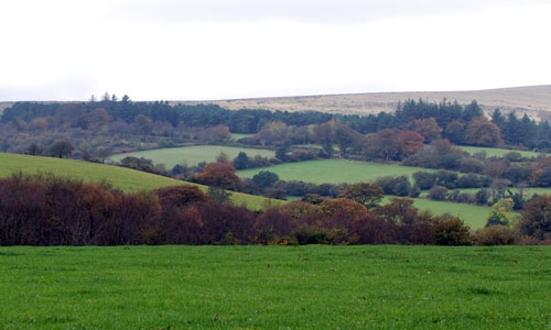
This is a transitional landscape, linking the upland moor with the lowlands to the south, and forming the backdrop to many views of Dartmoor from the south. It is a landscape of changing colours and textures, with the golds, browns and purples of the moorland contrasting with the vivid greens of the pasture below. Fast-flowing streams rush down the hillsides in steep, narrow valleys which are often clothed in oak woodland. Farms and small villages nestle in valleys or in the folds of the hillsides, surrounded by ancient patterns of fields and linked by a network of twisting sunken lanes. On the moorland there is an extraordinary sense of time-depth, with many abandoned settlements from prehistoric and medieval periods reflecting the ebb and flow of people’s colonisation of the moor.
- Context
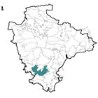
 This area comprises the southern part of Dartmoor and encompasses upland moorland and the south-facing slopes and river valleys below it. The area itself forms a transition from upland to lowland, and its boundaries with surrounding character areas are gradual. It forms a ‘horseshoe’ shape around High Dartmoor South, with Central Dartmoor to the north. To the west is the River Tavy Middle Valley; to the south-west the Plymouth Northern Wooded Slopes; to the south the Plymouth and Modbury Farmland and the Mid Avon Valley and West Dart Valleys and Ridges; and to the east the East Dartmoor Moorland Fringes and the Mid Dart Valley and Slopes.
 - Constituent Landscape Character Types
Constituent LCTs: 2D: Moorland Edge Slopes, 3D: Upland River Valleys, 1L: Upland Moorland with Tors, 5A: Inland Elevated Undulating Land Part of NCA: 150: Dartmoor - Distinctive Characteristics
- The southern part of the granite ‘dome’ of Dartmoor, with ridges of higher land separating steep incised valleys.
- Smooth upland skylines, occasionally broken by rocky tors and boulders.
Pockets of minerals such as china clay resulting in ‘lunar landscapes’ of large open-cast mines beyond the National Park boundary. - Narrow, fast-flowing and rocky streams (including the Plym and Erme) flowing through steep, often wooded valleys.
- Artificial reservoirs occupying upland valleys, including Burrator and Avon Dam reservoirs.
- Deciduous or mixed woodland largely confined to valley slopes and pockets of evergreen plantation, particularly in the south-west part of the area and associated with Burrator reservoir.
- Valley side slopes used predominantly for pastoral agriculture, with some arable farming on flatter land around settlements.
- Extensive medieval field patterns on valley sides, enclosed by dry-stone walls, hedgebanks (often with individual or linear groups of trees) or hedgerows.
- Extensive areas of open moor (and isolated outlying areas) providing a rich diversity of semi-natural habitats, including grass moorland, heath, blanket bog, mires and grassland, grazed by Dartmoor ponies and local breeds of sheep and cattle.
- Very strong sense of time-depth from extraordinary concentrations of archaeological features –including prehistoric and medieval settlements, and the remains of tin working – often following river valleys up onto the high moor.
- Settlement generally consisting of isolated farms and small villages in valleys and tucked into sheltered folds of the hills.
- A strong local vernacular tradition using local granite, with occasional colourwashed cob farmhouses.
- The larger settlement of South Brent in its setting of undulating farmland.
- A network of twisting, sunken lanes connecting villages with each other and with open moorland.
- The A38 and larger modern settlements on the southern boundary of the National Park.
- Abrupt contrasts in landscape colour and texture between open moorland and enclosed farmland.
- A high degree of tranquillity and sense of remoteness, particularly on higher land.
Extensive views southwards across South Devon to the sea.
Evaluation
- Special qualities and features
- Very high scenic quality, most land being part of Dartmoor National Park.
- Backdrop to views of Dartmoor from much of South Devon; outstanding views southwards across South Devon to the sea.
- High levels of remoteness and tranquillity notably in upland areas away from the influence of the A38.
- Moorlands part of Dartmoor SAC and SSSI, providing habitats for flora, insects, butterflies and ground nesting birds.
- Sites of county importance for woodland, moorland Rhôs pasture and wetland (CWSs).
- Extensive areas of ancient woodland, particularly on valley sides including Shaugh Prior woods SSSI, designated for their rich bryophyte (moss and liverwort) and lichen communities, and forming part of the South Dartmoor Woods SAC).
- Numerous RIGSs covering geological exposures, including tors and quarry sites.
Numerous SMs covering outstanding assemblages of pre-historic and medieval sites (including hut circles, field boundaries, cairns, stone rows and standing stones) and later industrial archaeology associated with tin mining. - Strong, intact field patterns of rectilinear newtakes on moorland edges, and small medieval fields on the valley slopes.
- Conservation Area covering the historic core of South Brent, plus numerous historic buildings (villages, farmsteads, granite hump-backed bridges etc) throughout the area.
- Traditional orchards around Cornwood.
- Extensive areas of access land on upland areas, and a network of lanes and public rights of way on lower slopes and Two Moors Way long distance route crossing the area north-south.
Forces for Change and Their Landscape Implications:
- Past and current
- Visual and noise impacts from china clay quarrying on Lee Moor in the south-west of the area; within the worked quarries there is a white ‘lunar landscape’.
- The spread of modern development on the edges of settlements such as Ivybridge and South Brent, with associated visual impacts on the southern part of the area.
- Traffic noise from the A38 reducing tranquillity.
- Loss of upland semi-natural habitats as a result of inappropriate grazing, burning, peat cutting, moorland drainage and changes in moorland management over several centuries.
- A localised lack of woodland management resulting in a loss of species diversity.
- Loss of traditional orchards, with implications for the landscape and species diversity.
- Damming of valleys to create reservoirs.
- Coniferous plantations around reservoirs and on open moorland e.g. in the Meavy valley, contrasting with the surrounding landscape in their colour, mass and texture.
- Intensification of agriculture, and a gradual loss of traditional skills such as hedge laying resulting in an erosion of traditional agricultural landscape features such as hedgebanks.
- Spread of equine development, particularly round Yelverton, resulting in splitting of farms and the gradual encroachment of ménages, paddocks and other features into the landscape.
- Intensive recreational use of upland areas resulting in erosion and damage to paths, and damage to geological and archaeological features.
- Light pollution from Plymouth and other settlements reducing the darkness of night skies.
- Future
- Further expansion of china clay extraction, tipping and quarrying outside the National Park (particularly Lee Moor) as well as other quarrying sites (e.g. Hemerdon Quarry) landfill and energy from waste sites, potentially impacting on views and levels of tranquillity.
- Development pressure from within and outside the National Park (e.g. the A38 road corridor and the Plymouth conurbation) leading to potential demand for new water supply reservoirs and quarries for aggregate and local building stone.
- Further recreational demand from expanding urban centres in the vicinity, such as Plymouth.
- Increased areas of coniferous plantation and woodland to filter water, minimise downstream flooding, store carbon and provide low carbon fuel (through coppice management).
- Potential loss of or change in oak- and beech-dominated valley woodlands due to spread of Phytophthora, intolerance of water level extremes and more frequent storm events.
- Changes in agricultural grants and funding potentially affecting grazing levels and the repair of traditional landscape features such as hedgebanks.
- Climate change potentially affecting growing seasons, temperature and precipitation levels, resulting in habitat loss and changes in species composition.
- Increased autumn and winter precipitation leading to flood risk and poaching of river banks.
- Increased demand for wind turbines and communications masts on higher ground as well as for domestic and community-scale solar panels and small wind turbines with cumulative landscape effects.
- Potential future hydro-power schemes.
Strategy
- Overall Strategy:
To protect the landscape’s scenic quality and open skylines, strengthen its special qualities and features, and enhance its appearance as a backdrop to views of Dartmoor from South Devon. The area’s strong historic character is protected and enhanced, with the time-depth associated with archaeological sites and historic villages retained. Valuable upland semi-natural habitats are protected and appropriately managed to maximise their roles in biodiversity, water catchment, water storage and carbon sequestration. Development is controlled to minimise visual and audible impacts on the National Park. Sustainable agriculture is supported and distinctive features of the area are kept in good repair. Sustainable levels of recreation are encouraged, but without detriment to sensitive habitats or features.
Guidelines:
- Protect
- Protect and appropriately manage the landscape’s numerous historic sites and features, including prehistoric hut circles, cairns, settlements, standing stones and mining features.
- Protect and maintain the rectilinear pattern of newtakes on the edge of the open moorland, and small-scale medieval field patterns lower down the valley sides, restoring hedgebanks and walls using traditional techniques and materials.
- Protect the area’s sparsely settled character and views to high moorland. Resist new development within or on the edges of common land, and carefully control new development outside existing village envelopes.
- Protect the strong unifying local vernacular of granite and slate, with some colourwashing and thatch. New development should utilise similar materials and styles whilst seeking to incorporate sustainable design.
- Protect the open skylines and distinctive geological features of the landscape, including the granite tors. Remove scrub through appropriate grazing, and provide guidance and interpretation.
- Protect the landscape’s network of quiet lanes enclosed by woodland and species-rich hedgebanks, resisting unsympathetic highways improvements or signage.
- Protect and repair characteristic built features such as stone hump-backed bridges.
- Protect views outwards from the National Park which contribute to its setting.
- Protect important habitats, which contribute to biodiversity and landscape quality.
- Manage
- Manage archaeological sites and their settings, with sensitive interpretation as necessary.
- Manage and enhance areas of upland common and open access land through appropriate levels of livestock grazing to maintain an open landscape and enhance biodiversity, encouraging sustainable numbers of Dartmoor ponies and local livestock breeds.
- Manage wetland habitats through grazing, and preservation and management of water flows, to minimise downstream flooding and enhance carbon sequestration.
- Manage and enhance the valleys’ semi-natural woodlands through techniques to promote longevity, species diversity and wood fuel; and through the control of deer and grey squirrels.
- Manage plantations for sustainable timber production, wildlife value and recreational use.
- Manage recreational use (particularly when concentrated along footpaths or as large-scale events) to minimise erosion and damage to archaeological sites and geological features.
- Manage recreational pressure at popular sites by promoting alternative locations and sustainable transport options.
- Plan
- Plan for the long-term restructuring of large conifer plantations in the Meavy valley, through gradual restocking with a range of native broadleaf species; consider retaining and promoting less prominent conifer plantations as recreational spaces (e.g. for mountain biking).
- Plan to create, extend and link semi-natural habitats such as heathland, mires, wetlands and woodlands (including through the restoration of lost field boundaries), and increase the numbers of traditional orchards.
- Plan a long-term strategy to restore disused areas of china clay quarrying and tipping around Lee Moor; it should aim to filter views and sounds of current quarrying, and provide wildlife habitats and green infrastructure links.
- Plan to ensure that any new quarrying activities are visually unobtrusive.
- Plan to consider the introduction of whisper tarmac on the A38 to enhance tranquillity.
- Plan reduction in light pollution from Plymouth and other settlements.