- Constituent Landscape Character Types
Constituent Landscape Character Types
3A: Upper Farmed and Wooded Valley Slopes
3D: Upland River Valleys
1E Wooded Ridges and Hilltops
Part of National Character Area
NCA 150: Dartmoor
NCA 151: South Devon
- Contextual Description
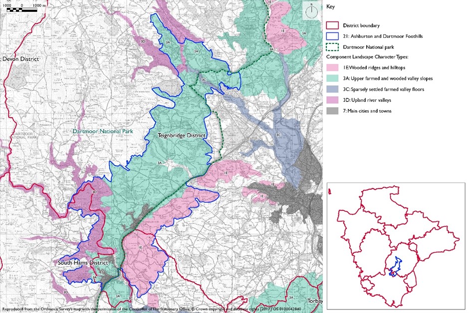
 This area is located at the eastern edge of Dartmoor and includes the town of Ashburton. To the west is an abrupt boundary with Central Dartmoor, defined on the ground by the change from enclosed fields to open moorland. The boundaries on the remaining sides are all much more gradual transitions into the many adjacent landscape character areas, including the East Dartmoor Moorland Fringes to the north; the Teign Valley and Slopes to the north-east; the Bovey Basin and the Denbury and Kerswell Farmlands to the east; the Mid Dart Valleys and Slopes to the south-east and the Southern Dartmoor and Fringes to the south.
Summary Description
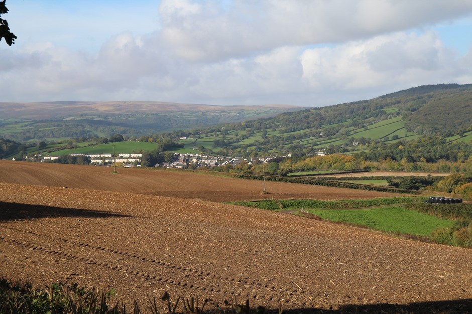
This landscape forms the eastern edge of Dartmoor National Park, and is characterised by a settled rural feel, hummocky topography and steep wooded valleys containing clean, fast-flowing streams. The largest of these contains the River Dart, which runs through a dramatic wooded gorge. The rolling hills and slopes of this area are defined by a strong mosaic of irregular and predominantly pastoral fields, semi-natural woodlands and hedgerow trees, which contribute to its well-wooded character. Patches of heath, bracken and rough grazing enhance its Dartmoor character, and together with the woodland provide constantly changing seasonal colours. The topography and aspect gives much of the area a strong sense of enclosure, with distinctive historic hamlets and farmsteads nestled into the landform.
- Distinctive Characteristics
- A rolling, hummocky landscape owing to a complex underlying geology including bands of limestone and slate, which has been cut by small tributary streams at the foot of undulating slopes.
- Steep slopes that rise above the Dart valley.
- Fast-flowing rivers quickly swelling in size after rainfall drains from the moorland, with rocky river beds creating sections of white-water, small waterfalls and gushing torrents.
- Extensive western oak and mixed woodland (much of it ancient), particularly on valley sides, providing important habitats for birds and other wildlife.
- A strong hedgerow structure with frequent hedgerow trees enhancing the area’s wooded character.
- Relict orchards, particularly in the northern part of the area.
- Dominated by pastoral farming, in medium sized irregular fields of medieval origin defined by hedgerows, stone-faced hedgebanks and stone walls; isolated patches of larger, more recent arable fields around settlements and further away from the moorland core.
- Pockets of semi-natural moorland habitat and extensively managed farmland with heathy vegetation, marshy areas, semi-improved and unimproved pasture.
- Past mining activity from the 16th to the 20th centuries evident along valleys through remnant mining structures and industrial remnants such as relic mine shafts.
- Dispersed settlement pattern characterised by individual vernacular farmsteads of local stone, slate, thatch and colourwash nestled into the folded landform or screened by woodland; colourwashed farmsteads seen against lush green pastures may create focal points within views.
- Larger settlements such as Buckfastleigh and Ashburton characterised by nucleated, stone-built historic cores, surrounded by more recent development.
- Narrow winding lanes often running across slopes, but with very steep downhill sections contrasting with the busy A38, which runs through the broader Ashburton Valley.
- An intimate, human-scale landscape, enclosed and unified by landform and tree cover, with occasional framed views to the wider landscape where topography and gaps in hedgerows permit.
- A strong sense of remoteness, tranquillity and history.
- Varied and colourful valleys, with broadleaved woodlands providing seasonal interest through a range of colours including autumnal reds and oranges, and blankets of bluebells, primroses and wild garlic in spring; the sound of running water provides a backdrop.
Evaluation
- Special qualities and features
- High scenic quality – largely within Dartmoor National Park but contrasting with the unenclosed moorland above.
- An important area of landscape transition between the wild moorland core of the National Park and the developed areas on its periphery.
- High levels of tranquillity, particularly away from the A38.
- Extensive ancient semi-natural woodland (particularly within the Dart valley) and a concentration of veteran trees in the northern part of the area.
- Several woodlands designated SAC, SSSI or CWS for their nature conservation importance, in particular for their western oak woodland with rich bryophyte (moss and liverwort) and lichen communities; Yarner Wood is NNR.
- Other important habitats including species-rich grasslands, marshy areas, bracken communities (supporting rare fritillary butterflies) and traditional orchards as well as fields of semi-improved pasture enclosed by hedgebanks that provide foraging areas for rare bat species.
- Important geological sites including caves and quarries, some designated as SSSI or RIGS.
- SMs including Holne Chase Castle above the Dart valley, Hembury Hillfort, prehistoric cairns and earthworks.
- Conservation Areas covering the historic cores of Ashburton and Buckfastleigh, plus numerous historic buildings (houses, farms, bridges, mills etc) throughout the area.
- Dart valley (including the River Dart Country Park) a popular recreation resource for locals and visitors.
- Good network of lanes, tracks and footpaths providing access into the area.
Forces for Change and Their Landscape Implications
- Past and current
- 20th century intensification of agriculture, resulting in field enlargement, lack of management of traditional field boundaries and increased arable use in place of pasture and rough grazing.
- Ongoing decline in traditional skills including hedge laying and thatching, with associated impacts on landscape character and the built vernacular.
- Loss in the number and extent of traditional orchards.
- Spread of equine development changing the character of the landscape.
- Threatened spread of exotic species within ancient semi-natural woodland, including rhododendron and Himalayan balsam, also reflecting a decline in woodland management.
- Increase in traffic levels on rural roads, particularly on routes linking with the A38 and settlements on and beyond the National Park boundary.
- Visually-intrusive 20th century expansion of housing and industry on edges of larger settlements.
- Ongoing quarrying activity at Ashburton that has visual impacts and reduces tranquillity.
- Popularity of riverside locations for tourism and recreation, leading to traffic congestion on rural roads, erosion of river banks and reductions in local levels of tranquillity – particularly in the summer months.
- Successful orchard restoration and community-supported agriculture projects at the National Trust’s Parke Estate.
- Pressure for new solar farms.
- Future
- Uncertain future for the agricultural economy – levels of future funding support and market prices for farmed products unknown – which will have impacts on the landscape’s character.
- Continued trend in hobby farming and equine enterprises – leading to a further dilution of traditional farming practices in the landscape.
- The introduction of large-scale agricultural buildings into the landscape.
- Continuing decline in rural skills such as hedge laying and woodland management, threatening the age and species diversity of existing semi-natural woodlands.
- Change in woodland species composition as new pests and diseases spread (particularly Phytophthora) and species intolerant of water level extremes die back as a result of climate change; individual trees more susceptible to damage from the increasing frequency and magnitude of storm events.
- Demand for woodfuel resulting in increased extraction from woodlands.
- Increased frequency of summer droughts, but increased autumn and winter precipitation levels leading to increased flood risk.
- Longer growing season and increased growth rates of vegetation (e.g. bracken, gorse and secondary woodland) leading to further scrubbing up of hedgebanks and rough grazing land.
- Demand for new quarries and expansion of existing sites to supply building stone and aggregates for new development – e.g. Linhay Hill limestone quarry near Ashburton.
- Ongoing development pressure and demand for low-cost housing in existing settlements.
- Demand for renewable energy schemes including wind turbines on higher ground (capitalising on the screening effects of the area’s undulating topography) and hydro-electric power on larger rivers.
- Pressure for new solar farms which could have a very high visual impact on this elevated landscape.
- Demand for domestic and community-scale renewable energy installations which could have a cumulative impact on the landscape and built form.
- Potential increase in the area of coniferous plantation and woodland, to filter water, minimise downstream flooding, store carbon and provide low carbon fuel (through coppicing).
- Ongoing increase in traffic requiring highways measures which are out of keeping with the character of the landscape’s narrow rural lanes.
- Increase in UK-based tourism with associated demands for new attractions (e.g. golf courses) and infrastructure, as well as an increase in traffic levels, car parking, recreational pressures (particularly at ‘honeypot’ sites) and farm conversions.
- The change /transition to the new land management system (ELMS) promises to be positive for the environment- more so than the CAP- and offers opportunity to strengthen landscape features and characteristics.
- Need for landfill/landraising within construction sites and modification of natural topography.
- Need for attenuation basins as part of SuDS as a requirement of new development.
Strategy
- Overall Strategy
To protect the scenic quality of this landscape within Dartmoor National Park, strengthening its special qualities and features, including its rivers and steep wooded valleys. Semi-natural woodlands on valley sides, areas of pasture and wet woodland are managed to increase the resistance of their habitats and species to climate change, to protect water quality and to minimise downstream flooding. The tranquil, unspoilt character of the river valleys is protected, but they are still enjoyed by local people and visitors. The potential to use the streams to generate hydro-electric power for local use is explored sensitively. The field patterns, hedgebanks, and vernacular buildings within the landscape are retained and enhanced. The demands for additional housing and quarrying are met in a sustainable manner which does not compromise the visual qualities of the landscape.
Guidelines
- Protect
- Protect and maintain the strong irregular field patterns of the landscape, repairing lost and gappy hedgebanks whilst respecting local variations in construction and plant species.
- Protect, appropriately manage and interpret the landscape’s archaeological heritage, particularly features associated with mining activity.
- Protect historic water features such as leats and weirs.
- Protect the dispersed settlement pattern and resist the further linear spread of new developments (including caravan and camping sites) to retain the landscape’s undeveloped character.
- Protect ridgelines and prominent slopes (including views to and from Dartmoor) from new development; any new development should utilise the screening effects of the landscape’s topography and woodland to minimise its impact.
- Protect in good repair traditional vernacular buildings and features; limited new development should use the same materials and styles where possible (whilst incorporating sustainable design).
- Protect and manage ancient and veteran trees as important features of this landscape.
- Protect the high levels of tranquillity which exist over much of the area.
- Protect valuable habitats.
- Manage
- Manage semi-natural woodlands through traditional techniques (e.g. coppicing and grazing) to promote a diverse age and species structure and increase resistance to climate change.
- Manage and enhance the biodiversity of the farmed landscape, particularly ‘marginal’ areas such as rough grazing land, patches of heathland and field boundaries to enhance the area’s Dartmoor character; support farming communities and retain the viability of traditional agriculture.
- Manage and enhance important wetland habitats such as Rhôs pasture and wet woodland through the management of water flows, control of invasive vegetation and use of traditional agricultural techniques. This will enhance biodiversity and control stream water flows.
- Restore and manage areas of relict traditional orchards to encourage biodiversity and local fruit varieties.
- Manage recreational pressure at popular sites by promoting alternative locations and sustainable transport options. Any signage or infrastructure requirements should be kept to a minimum and be sensitivity sited within the landscape setting.
- Manage areas of semi-natural habitat. Link and extend habitats where possible to increase biodiversity, contribute to nature recovery networks and provide suitable habitats for flora and fauna.
- Plan
- Plan to create, extend and link woodland and wetland habitats to increase biodiversity, filter views of roads and development, enhance water storage capacity and improve water quality through reducing soil erosion and agricultural runoff; natural regeneration of woodland should also be encouraged.
- Plan for the potential development of small scale hydro schemes as a source of renewable energy on suitable sites.
- Plan for the consideration of whisper tarmac on the A38 where traffic noise impacts on tranquillity levels within this area.
- Plan for the creation of traditional orchards, including community projects to promote local food and drink production.
- Plan for the establishment of future generations of veteran trees.
- Plan for the sustainable development of settlements, including green infrastructure provision to meet local needs.
- Plan a long-term strategy for the restoration of quarry sites.
- Plan to reduce light pollution from nearby roads and settlements.
- Plan to mitigate climate change impacts allowing natural process to take place where possible.
- Plan a landscape-led response to the UK-wide policy drive for increased tree and woodland planting, implementing Devon Local Nature Partnership’s ‘Right Place, Right Tree’ principles to create a balance of climate-resilient native species appropriate to the local landscape.
- Plan to contribute to nature recovery networks and provide suitable habitats for flora and fauna.
- Plan for the sensitive location of new development. Within the National Park boundaries, follow the Dartmoor National Park Design Guide New housing development guidelines include: Reinforce a sense of place in Dartmoor’s towns and villages by respecting the existing built heritage. Respect the unique views and landscapes in the National Park. Commercial, industrial and community development guidelines include: Proposals should be of appropriate design and scale and have sound environmental credentials. Developments should generally be located within or adjacent to existing settlements. https://www.dartmoor.gov.uk/living-and-working/planning/planning-policy/supplementary-planning-documents/design-guide
- Plan for the sensitive location of new development in areas adjacent to the National Park boundaries, similarly, respect the unique views and landscapes in the National Park and proposals should be of appropriate design and scale.
- Plan for new slurry tanks to be grouped with other farm buildings, recess into ground, use natural topography and trees for screening and integration and sensitive colour treatment with dark recessive colour to minimise visual impact.
- Plan for landfill/landraising of development sites and modification of natural topography by designing new landform in character with topographic context, avoid artificial engineered landforms, and integrate into the landscape.
- Plan for attenuation basins as part of SuDS required as part of development designing for biodiversity and amenity enhancement, where possible to enhance development not just provide engineering function.