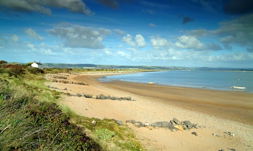
This is a flat, sky-dominated landscape with strong sensory characteristics. The habitats within the mosaic (dunes, beach, saltmarsh, mudflats and farmland) each have unique qualities of pattern, colour and texture which are juxtaposed in different combinations. The salty smell of mudflats and the sea are ever-present, as are the calls of birds. Within the dunes, the landscape feels disorientating, and has a strong sense of enclosure, isolation and wilderness. This contrasts with the open views towards the surrounding settlements, and the time-depth associated with the strip fields at Braunton. The estuary settlements have a strong maritime character, with historic quays and impressive bridges.
- Context
This area comprises the estuary of the Taw and Torridge Rivers, and a small margin of land on either side. Northam Burrows and the dune system at Braunton Burrows are also included in the area. This area is distinctive for its flat topography and the dominance of the sea and estuary. To the north are the North Devon Coastal Downs and the North Devon Downs, to the east (beyond Barnstaple) the Codden Hill and Wooded Estates, and to the south the Taw Valley, High Culm Ridges, Torridge Valley and the Bideford Bay Coast.
The area forms part of the Exmoor National Character Area (NCA 145).
- Constituent Landscape Character Types
Constituent LCTs: 4A: Estuaries, 4B: Marine Levels, 4E: Extensive Inter-Tidal Sands, 4F: Dunes, 7: Main Cities and Towns Part of NCA: 145: Exmoor - Distinctive Characteristics
- Carboniferous Culm Measures south of the Taw; Devonian sandstones, limestones and mudstones to the north; underlying geology topped with tidal and alluvial clay, silt and sand.
- Active geomorphological processes, including pebble spit and dune formation.
- Low-lying, open and flat topography, at or very close to sea level, surrounded by higher land to the south and north.
- Extensive areas of grazing marsh, e.g. at Northam Burrows, and on Braunton Marsh; some arable land on better quality soils; very limited tree and woodland cover.
- Diverse field boundaries, including brackish ditches, stone walls, thorn hedges and (on Braunton Great Field) earth banks marking individual landsherds or furlongs.
- Extensive areas of active sand dunes and maritime grasslands on both sides of the estuary, framing a rich diversity of estuarine habitats including salt-marsh, sand spits, lagoons and reclaimed farmland.
- Very important for biodiversity, supporting major populations of migrating and overwintering wading birds, fish (including sea trout and salmon), and rare plants and flowers.
- Diverse archaeology, including a submerged forest at Westward Ho!, prehistoric and Roman organic features preserved in anaerobic mud, and important 20th century military sites (anti-tank defences and concrete mock-ups of landing craft where American troops practised for the Normandy Landings).
- Important historic and cultural landscapes, including Braunton Marsh (drained in the early 19th century and dotted with roadside dykes, sluices, mortared stone walls and small stone linhays) and a rare surviving example of traditional strip-field arable farming at Braunton Great Field.
- Strong maritime history linked to trade, evidenced through historic quays and impressive bridges.
- Few settlements except for the peripheral towns of Braunton, Northam, Westward Ho!, Barnstaple and Bideford, which have a visual influence on nearby parts of the estuary.
- Open estuarine views and seascape of Bideford Bay contrasting with the sense of remoteness, isolation and wilderness experienced within the dunes.
Evaluation
- Special Qualities and Features:
- Exceptionally high scenic quality, with most coastal areas falling within the North Devon Coast AONB; northern part of the area also defined Heritage Coast.
- High tranquillity at Braunton Burrows and Saunton Sands.
- Sand dune system at Braunton Burrows designated nationally (SSSI) and internationally (SAC and North Devon Biosphere Reserve) for its complete active dune sequence, managed under Higher Level Stewardship.
- Extensive areas of SSSI covering the river channels and their associated estuarine habitats including mudflats, saltmarsh, grazing marsh and sand spits.
- RIGS site covering tidal deposits at The Skern, near Appledore.
- Prehistoric stone row on Isley Marsh designated SM.
- Numerous listed buildings, including the impressive historic bridges at Barnstaple and Bideford.
- Conservation Areas covering the historic cores of adjoining settlements including Northam, Appledore, Braunton, Barnstaple, Fremington, Instow and Bideford.
- Cultural associations with the popular composer John Gay (1685-1732) who was born in Barnstaple, and the 19th century author Charles Kingsley who wrote novel Westward Ho! whilst living in Bideford.
- Popular recreation resource, including Country Park, golf courses, and wide beaches good for surfing, bathing, and sand yachting; North Devon Royal Golf Course at Northam Burrows is the oldest golf course in Britain.
- Access land and common land at Northam Burrows.
- South West Coast Path and Tarka Trail recreational route, both following disused railway lines along the estuary, then continuing along the inshore side of Braunton Burrows.
Forces for Change and Their Landscape Implications:
- Past and Current
- Poor agricultural management, leading to under-grazing or overgrazing of valuable habitats and consequent loss of biodiversity.
- Damage to sensitive nature conservation sites by over-use of fertilizer on adjacent agricultural areas and golf course.
- Reduction in numbers of strip-holders at Braunton Great Field, leading to a loss of characteristic landsherd/ furlong boundaries.
- Use of farmland for pony paddocks, changing its character.
- Construction of airfield and military base at Chivenor, parts of which now have an unmanaged and neglected character.
- Past and ongoing military use of Braunton Burrows.
- Past development of golf courses on sensitive dune environments.
- Visual impacts and light pollution from development at adjacent settlements, including Westward Ho!, Bideford and Barnstaple; skyline development at Westward Ho! and large buildings on Westward Ho! Seafront affecting the edge of the AONB.
- Modern engineered features such as bridges, main roads and sewage works that affect the traditional character of the estuary setting and impact on levels of tranquillity.
- Construction of masts on downland summits at Saunton Down just to the north affecting the backdrop to views northwards across the estuary.
- The consented large-scale onshore wind farm at Fullabrook Down which will be visible from this area and affect the character of the backdrop to the estuary.
- Trampling and erosion as a result of recreation damaging fragile dune system habitats.
- Increased provision of recreation facilities and caravan parks, reducing the sense of wildness on and around the dunes.
- Loss of organic matter (seaweed) due to beach cleaning, affecting the strand-line ecosystem.
- Past sand extraction at Crow Point affecting its ability to protect the estuary mouth from coastal erosion.
- Future
- Uncertainty over future levels of agricultural grants and funding, potentially resulting in traditional farming methods such as strip fields and use of ‘marginal’ land such as grazing marsh and sand dunes becoming unviable; this may affect management of vegetation on Braunton Burrows.
- Potential sea level rise, with impacts on tidal habitats and loss of agricultural land.
- Potential environmental impacts from the old tip at Northam Burrows.
- Loss of sand dunes, resulting from higher sea levels, and greater wave energy due to increased frequency and intensity of storms. Changes may also occur in the volumes of sand being deposited.
- Potential changes in water table potentially affecting dune systems and artificially-drained areas such as Braunton Marsh
- Changes in species composition as a result of alterations to growing seasons and the introduction of new species, pests and diseases.
- Possible land loss at Northam Burrows due to Shoreline Management Plan proposal to retain sea defences for Westward Ho! and Northam, but to allow managed realignment of the pebble spit.
- Uncertain future of Chivenor airfield.
- Continued military use of Braunton Burrows.
- Continued demand for recreation facilities, changing the character of the area.
- Increased traffic congestion and development pressure in and around Braunton.
- Demand for renewable energy sources, including tidal schemes, offshore and onshore wind, all potentially affecting the character of the area.
Strategy
- Overall Strategy:
To protect the landscape’s high scenic quality within (or as a setting to) the North Devon Coast AONB, and to sustain its important nature conservation sites and rare historic landscapes. The dune systems and other important habitats within the area are well managed and their resilience to climate change is enhanced. Recreation is encouraged, but a good balance between recreation and conservation is retained. The historic and cultural landscapes of Braunton Great Field and Braunton Marsh are retained in active agricultural use and well managed using traditional techniques. Development in surrounding areas is sensitivity designed and sited to minimise its intrusion into views from the estuary; and the area’s distinctive seascapes are protected.
Guidelines:
- Protect
- Protect the open character of the estuary and views from and to surrounding landscapes.
- Protect the open and undeveloped character of Braunton Great Field, ensuring that any limited new development in the area respects the scale and historic character of the landscape.
- Protect and restore where appropriate historic features such as quays, bridges and agricultural structures (including those of Braunton Marsh and Braunton Great Field); provide sensitive interpretation where appropriate to increase the public’s awareness of these features.
- Protect the area’s distinctive seascapes and open views across Bideford Bay.
- Manage
- Manage the estuary’s internationally important habitats including dunes, saltmarshes and mudflats, using traditional techniques including appropriate levels of grazing, in accordance with North Devon Biosphere Reserve guidelines.
- Manage the land within the North Devon Coast AONB in accordance with the AONB’s statutory duties.
- Manage agricultural land fringing the estuary, encouraging farmers and commoners to use the pastures and marshes for appropriate levels of grazing as part of their farming systems.
- Manage Braunton Marsh through continued agricultural grazing.
- Manage fertilizer run-off from adjacent areas to ensure no contamination of nature conservation sites.
- Manage and support continuation of arable and horticultural farming on Braunton Great Field within the original medieval strips.
- Manage hedgerows around Gallowell, Lower Thorn and Middle Thorn to reinforce the sense of a well-managed landscape.
- Manage recreational use of the area to ensure that the correct balance between recreation and conservation interests is retained.
- Plan
- Plan to mitigate climate change impacts (particularly the affects of sea level rise and coastal erosion), allowing natural process to take place where possible, whilst ensuring that local communities are involved in making decisions about their future landscape.
- Plan for opportunities to expand estuarine and wetland habitats to build resilience to future climate change.
- Plan for the sensitive future expansion of towns on the estuary fringes, incorporating new development into the landscape setting of the estuary with great care; providing green infrastructure links to routes such as the Tarka Trail and South West Coast Path; and ensuring that any new development – particularly within or adjacent to the AONB – is sensitive in terms of its design and scale.
- Plan to protect sensitive skylines (e.g., Westward Ho!) from ridgeline development.
- Plan to reduce light pollution from Barnstaple, Bideford and other settlements and roads.