1. Introduction
1.1 Minerals Planning in Devon
Devon County Council is the minerals and waste planning authority for Devon, with responsibility for preparing minerals and waste policies, determining minerals and waste planning applications and ensuring that development is in accordance with the planning permission granted. This excludes Dartmoor and Exmoor National Parks and the unitary authority areas of Plymouth and Torbay, which are responsible for minerals and waste planning in these areas.
1.2 Purpose of the Monitoring Report
The 2004 Act (as amended) requires the County Council to prepare a Minerals and Waste Development Scheme [MWDS]. This Scheme is intended to provide a programme for the preparation of the development plan documents that will be contained within the Minerals and Waste Development Framework, and progress in implementing the MWDS is to be monitored through a Monitoring Report.
The Fifth Revision of the Minerals and Waste Development Scheme was published in March 2018[1] and notes the Minerals Plan as having been adopted. It indicates that in the event of an update to the Minerals Plan being required as a result of a review, a further revision of the Scheme will be prepared.
[1] Available in the Development Scheme tab at https://www.devon.gov.uk/planning/planning-policies/minerals-and-waste-policy
2. Minerals Policy: Assessment of Performance and Effects
The below assessment of performance and effects is based on the indicators contained within the Implementation and Monitoring Chapter in Table 9.2 of the Devon Minerals Plan. It should be borne in mind that the number of planning applications for minerals development received by the County Council in any one year is small, and that a large proportion of the Plan policies may not be used in the determination of planning applications every year. A schedule of 2021 planning applications for mineral development is provided in Appendix 1.
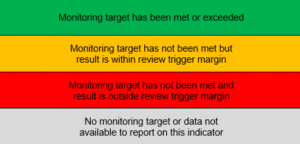
This section of the monitoring report has been updated from previous years to provide results in a way which more clearly identifies where monitoring targets are not being met. This includes the adoption of a traffic light system for the results as defined below.
The indicators for each of the Plan’s six key objectives have been grouped into a table for each. Where indicators have score red as above, a review has been undertaken. This is presented after the results table for each objective.
2.1 Objective 1: Spatial Strategy
ndicators 1.1 – 1.5 seek to ensure minerals development adhere to the Spatial Strategy contained within the Devon Minerals Plan.
| Indicator | Baseline | Target | Monitoring Trigger | 2021 Result |
|---|---|---|---|---|
| 1.1 Number of locations in Devon for working of industrial minerals | Four (2015) (Lee Moor, Drakelands, Bovey Basin, Peters Marland) | No reduction | Closure of one location | Three (Red RAG Rating) |
| 1.2 Proportion of Devon’s land-won and secondary aggregates originating within the M5/A38 Corridor | 90.8% (2015) | 85% | Significant variance (+/- 10%) from target indicating over-concentration of production and/or lack of local supply | 90.1% (Green RAG rating) |
| 1.3 Proportion of Devon’s annual sales of land-won sand and gravel resources originating from the Budleigh Salterton Pebblebeds | 80.7% (2015) | 85% | Significant variance (+/- 10%) from target indicating over-concentration of production and/or lack of local supply | 91.1% (Green RAG rating) |
| 1.4 Proportion of Devon’s land-won and secondary aggregates sold to destinations within wider Devon | 86.0% (2014) | 85% | Significant variance (+/- 10%) from target indicating increase reliance on imported aggregates or reduced contribution to sub-regional needs | 72% (Red RAG rating) |
| 1.5 Number of planning permissions for mineral extraction that are contrary to the Spatial Strategy | N/A | None | One permission | Zero (Green RAG rating) |
In relation to indicator 1.1, the reduction from the baseline figure is due to the closure of Hemerdon (formally known as Drakelands). During the reporting year, and at the time of writing, the current operator has expressed a clear intention to re-start the winning of tungsten and tin. Therefore, an update to the policy is not considered necessary at this stage.
In relation to indicator 1.4, the result of 72% means the monitoring trigger has been breached for the third year in a row, however, the result has increased from the previous year’s result of 70%, but under the 2019 results of 74%. This suggests that the proportion of Devon’s land-won and secondary aggregates retained within Devon is remaining relatively consistent. This will continue to be monitored in future years, but it is not considered necessary to update the Minerals Plan given the reliance on the commercial market.
Overall, it is considered that mineral development has adhered to the Spatial Strategy during the reporting year.
2.2 Objective 2: Safeguarding Mineral Resources and Infrastructure
Indicators 2.1 – 2.2 seek to ensure policy is effectively safeguarding mineral resources and associated infrastructure from sterilisation by other forms of development.
| Indicator | Baseline | Target | Monitoring Trigger | 2021 Result |
|---|---|---|---|---|
| 2.1 Number of applications approved by local planning authorities in Devon contrary to an objection on mineral safeguarding grounds by the County Council | 0 (2014) | 0 | Approval of development sterilising a strategic mineral resource contrary to the criteria of Policy M2 | Zero (Green RAG rating) |
| 2.2 Number of operational mineral wharves and railheads in Devon | Six (2015) | No reduction | Closure of wharf or railhead without alternative provision being available | Five (Green RAG rating) |
Devon County Council objected to two planning applications on mineral safeguarding grounds, both of which were within Teignbridge District Council’s jurisdiction. The applications were for:
- the replacement of a mobile home with a dwelling in Teigngrace (21/02121/FUL); and
- up to 40 residential dwellings in Chudleigh Knighton (21/00016/MAJ).
Planning permission has been refused for both applications, with mineral safeguarding grounds being included within the reasons for refusal.
There was no change in the number of operational mineral wharves and railheads in Devon during 2021. As discussed in the previous annual monitoring report for 2020, the reduction in the 2015 baseline from six to five facilities is due to one wharf in Appledore ceasing to be used for the landing of marine dredged sand and gravel in 2017. However, as two other wharves remain available in the locality, it is not necessary to seek replacement provision.
2.3 Objective 3: Industrial Minerals
Indicators 3.1 – 3.6 seek to ensure policy is maintaining Devon’s ability to assist in meeting national and international demand for those industrial minerals found within the County.
| Indicator | Baseline | Target | Monitoring Trigger | 2021 Result |
|---|---|---|---|---|
| 3.1 Number of operational china clay sites | Three (2015) | No reduction | Closure of a site | Three (Green RAG rating) |
| 3.2 Number of operational ball clay sites | Eight (2015) | No reduction | Closure of a site | Eight (Green RAG rating) |
| 3.3 Number of operational metalliferous mineral sites | One (2015) | No reduction | Closure of a site | Zero (Amber RAG rating) |
| 3.4 Annual UK sales of china clay | 1.090 million tonnes (2014) | No reduction | Significant variation (+/- 20%) from baseline | 0.635million tonnes (-36% from baseline) (Red RAG rating) |
| 3.5 Annual UK sales of ball clay | 0.748 million tonnes (2013) | No reduction | Significant variation (+/- 20%) from baseline | 0.696 million tonnes (-15% from baseline) (Amber RAG rating) |
| 3.6 Annual UK sales of tungsten | Not commenced | N/A | Cessation of operations prior to completion | 0 (Grey RAG rating) |
The results for indicator 3.1 and 3.2 relating to the number of operational sites have not changed since 2020. The reduction from the baseline in indicator 3.3 is due to the closure of Hemerdon. The site is currently exporting secondary aggregates but not tungsten or tin. However, the current operator has expressed a clear intention to re-start the winning of tungsten and tin, as outlined in objective 1. As a result of this, the indicator can be scored as amber.
Indicators 3.4, 3.5 and 3.6 rely on data that is included within BGS’s UK Minerals Yearbook. At the time of writing, the data for 2021 has not been published. Given the delay between each report, this report will use the previous years data to complete these indicators.
2.4 Objective 4: Aggregate Minerals
Indicators 4.1 – 4.3 seek to ensure policy maintains a sustainable, steady and adequate supply of aggregates, making maximum use of the County’s resources of secondary and recycled materials and providing new resources when required.
| Indicator | Baseline | Target | Monitoring Trigger | 2021 Result |
|---|---|---|---|---|
| 4.1 Landbank within wider Devon of: (a) crushed rock (b) sand and gravel | 2015 (end) (a) 48.9 yrs (b) 12.5 yrs | Minimum of: (a) 15 yrs (b) 10 yrs | The crushed rock landbank dropping below 10 years and/or the sand and gravel landbank dropping below 7 years | a) 44.4 years b) 6.5 years (Red RAG rating) |
| 4.2 Average annual sales within wider Devon of land-won aggregates: (a) crushed rock over the past 10 years; (b) crushed rock over the past 3 years; (c) sand and gravel over the past 10 years; (d) sand and gravel over the past 3 years | (2015) (a) 2.35 mt (b) 2.70 mt (c) 0.56 mt (d) 0.52 mt | No target | The average calculated over the past 3 years exceeding that over the past 10 years | a) 2.635 mt b) 2.531 mt c) 0.514 mt d) 0.493 mt (Grey RAG rating) |
| 4.3 Proportion of total sales of land-won and secondary aggregates within wider Devon accounted for by secondary aggregates | 11.8% (2015) | 20% | Reduction to less than 10% | 17.7% (Amber RAG rating) |
The landbank for land-won crushed rock remained well above the minimum requirement set out in the NPPF for 2021, however, the landbank for sand and gravel at 6.5 years has fallen below the 7-year minimum required by the NPPF. The 2021 sand and gravel landbank is greater than that reported in 2020, this is due to the incorrect amount of reserves reported by a mineral operator, which resulted in an incorrect landbank figure being reported for 2020.
The Devon Minerals Plan provides for up to 9.2MT of sand and gravel at two sites which, if delivered, would sufficiently extend the life of the landbank and therefore it is not considered necessary to update the Minerals Plan policies at this stage. This situation will continue to be closely monitored. One of these sites is currently awaiting a decision from the Planning Inspectorate as whether planning permission will be granted or refused.
Sales of land-won aggregates appear to be recovering following the Covid-19 pandemic, with sales of both sand and gravel and crushed rock increasing between 2020 and 2021. However, the three years sales averages for crushed rock and sand and gravel remain below the ten years sales averages for the second consecutive year, perhaps highlighting the scale of the impact from the pandemic. Prior to 2020, the three years sales averages for crushed rock and sand and gravel have been above the ten years sales averages for a number of years.
Sales of secondary aggregates increased slightly from the previous year (0.701 million tonnes compared to 0.561 million tonnes in 2020) and the proportion of total sales of land won and secondary aggregates increased from 17.1% in 2020 to 17.7% in 2021. Although this is still below the target, it is well above the trigger for a review and has shown signs of improvement in recent years.
The Devon Minerals Plan is due to be reviewed, this will consider the fall in the sand and gravel landbank and whether the policy requires updating.
2.5 Objective 5: Building Stone
Indicators 5.1 – 5.2 seek to ensure policy enables local distinctiveness by securing an appropriate supply of local characteristic building materials.
| Indicator | Baseline | Target | Monitoring Trigger | 2021 Result |
|---|---|---|---|---|
| 5.1 Number of key building stones (Table 6.1) quarried in Devon | Seven (2015) | No reduction in the number of stone types | A reduction in the number of stone types | Eight (Green RAG rating) |
| 5.2 Sales of building stone produced in Devon | 7,061 tonnes (2015) | No reduction in annual production | A reduction in annual production of 15% in comparison with the previous year | 14,622 tonnes (+82.98% from previous year) (Green RAG rating) |
The 2021 result for indicator 5.1 has increased by one from the previous year, meaning the result for this indicator is now above the baseline figure of the seven Key Building Stone Types listed in Table 6.1 of the Devon Minerals Plan. This increase is due to Salcombe Stone (Upper Greensand Formation) now being quarried at Dunscombe Manor Quarry.
With regards to indicator 5.2, the large increase appears to be due to an aggregates quarry making sales in building stone.
The increase in operational building stone quarries and production indicates that the policy is successful enabling an appropriate supply of building stone.
2.6 Objective 6: Managing Mineral Development
Indicators 6.1 – 6.9 monitor policies that seek to manage mineral development in a manner that protects Devon’s communities from adverse impacts, conserves and enhances its environment, delivers positive benefits for its quality of life, green infrastructure and assists in mitigation of & adaptation to climate change.
| Indicator | Baseline | Target | Monitoring Trigger | 2021 Result |
|---|---|---|---|---|
| 6.1 The number of local quarry liaison groups | Seven | No reduction in the number of liaison groups | A reduction in the number of liaison groups (excluding cessation of a group due to closure of a quarry) | Four (reduction from baseline is a result of quarry closures) (Green RAG rating) |
| 6.2 The number of mineral planning applications incorporating sustainable drainage systems | N/A | 50% of relevant permissions | Less than 25% of permissions for extraction, tipping and/or built development | 67% (2 of 3 applications) (Green RAG rating) |
| 6.3 The area of best and most versatile agricultural land that would be lost to mineral development in new permissions | N/A | No loss | One new planning permission without adequate provision for restoration to agricultural land of similar quality | Two applications (Red RAG rating) |
| 6.4 New planning permissions for mineral development in an Area of Outstanding Natural Beauty or World Heritage Site | N/A | No new permissions that are contrary to Policy M18 | One new planning permission that is contrary to Policy M18 | One application (Amber RAG rating) |
| 6.5 New planning permissions for mineral development that result in the loss of, or harm to, assets of heritage value | N/A | No permissions that are contrary to Policy M19 | A planning permission resulting in substantial harm to a significant heritage asset contrary to Policy M19 | Two applications (Green RAG rating) |
| 6.6 Change in the area, type and condition of Devon BAP habitats caused by mineral development | N/A | No net loss of area or deterioration in condition | Significant net loss or deterioration in condition contrary to Policy M17 | No net loss of area (Green RAG rating) |
| 6.7 The number of planning permissions for mineral development within, or affecting, a SSSI or County Wildlife Site | N/A | No new permissions that are contrary to Policy M17 | One new planning permission that fails to deliver adequate mitigation of compensation for harm or is otherwise contrary to Policy M17 | Two applications within SSSI but there is deemed to be little or no impact. (Green RAG rating) |
| 6.8 Area of land within mineral sites restored for agricultural use and/or green infrastructure | N/A | All restoration to deliver green infrastructure | Absence of green infrastructure benefits in restoration implemented in the monitoring year | All the relevant applications had plans to restore the land back to agricultural use or green infrastructure. (Green RAG rating) |
| 6.9 The number of mineral planning applications that include provision for the use or generation of renewable or low-carbon energy | N/A | 50% of relevant applications | Less than 25% of permissions for extraction, processing plant and/or built development | 67% (2 of 3 applications) (Green RAG rating) |
The majority of the Managing Mineral Development indicators (6.1, 6.2, 6.6, 6.8 and 6.9) have been met or are in excess of the monitoring target. Only three of the thirteen applications determined in the monitoring period were relevant to indicators 6.2-6.9. The relevant applications are:
- DCC/3994/2017 – Cross boundary planning application for the extension to the existing Linhay Hill Quarry for the winning and working of minerals, with the development within Devon being the closure and removal of the junction of Alston Lane onto the A38, at Linhay Hill Quarry, Ashburton, Newton Abbot, TQ13 7ES
- DCC/4205/2020 – Extension of Uplyme Quarry at Uplyme Quarry (Shapwick Quarry), Shapwick Grange, Uplyme, Devon, DT7 3SP
- DCC/4189/2020 – Construction of asphalt plant and associated development including; importation and recycling of reclaimed asphalt product (RAP) for use in plant; and part-demolition of former In-vessel Composting Facility at Broadpath, Uffculme, Devon, EX15 3EP
With regards to indicator 6.1, four liaison groups met during 2021. This is an increase from last year’s result, which was impacted by the COVID-19 pandemic. The reduction from the baseline figure is due to quarry closures. Therefore, this does not represent an issue requiring a review of the Minerals Plan and as such the score has been adjusted to green.
The result for indicator 6.2 showed an improvement from the last monitoring report. Two of the relevant applications (DCC/3994/2017 & DCC/4189/2020) incorporated sustainable drainage systems within the proposals, either providing the information as part of the application or secured by condition. As such, this indicator can be scored as green.
With regards to indicator 6.3, there were two applications (DCC/3994/2017 and DCC/4205/2020) where agricultural land was lost, resulting in a red score. It does not appear that the applications specify whether this is Grade 3a or 3b agricultural land and, therefore, whether it is best and most versatile land. However, both of these planning permissions had adequate provision for the restoration of the site to agricultural land of similar quality and, therefore, a review of this policy is not considered necessary.
In relation to indicator 6.4, Uplyme Quarry is located within the East Devon AONB. The County Council Landscape Officer’s response to the application to extend the quarry (DCC/4205/2020) stated “the presence of the existing established quarry makes the proposal less sensitive”. It also stated that “the proposed mitigation design is appropriate and would moderate adverse effect on the landscape and on views as far as practically possible.” Therefore, this score can be an amber as the application was not considered to be contrary to Policy M18: Landscape and Visual Impact of the Devon Minerals Plan.
With regards to indicator 6.5, two of the applications (DCC/3994/2017 and DCC/4205/2020) were considered to result in a loss or harm to heritage value. With regards to the application at Linhay Hill (DCC/3994/2017), the committee report concluded that there would be less than substantial harm on designated heritage assets. In addition to this, the report also concludes that, there would not be any unacceptable effects on the non-designated heritage assets subject to a planning condition requiring archaeological work which would enable to impact to be mitigated. Similarly, with regards to the application at Uplyme Quarry (DCC/4205/2020), the DCC Historic Environment officer considered that the harm to the heritage value could be mitigated through a condition. As such, this score can be green, as there was no substantial harm and the applications were not contrary to Policy M19: The Historic Environment of the Devon Minerals Plan.
In relation to indicator 6.6, one application (DCC/4205/2020) had two small pockets of Biodiversity Action Plan (BAP) habitats within the application boundary. However, these pockets were within the existing quarry boundary but on the edge of the extension area and impacts were considered to be acceptable with sufficient conditions. It is considered that there would be no significant loss or deterioration in condition to the BAP habitat caused by this development. Therefore, this can be scored a green as the application was not considered to be contrary to Policy M17: Biodiversity and Geodiversity of the Devon Minerals Plan.
In relation to indicator 6.7, only one application (DCC/4205/2020) affected a Site of Special Scientific Interest (SSSI) and a County Wildlife Site (CWS). Uplyme quarry is designated as a geological SSSI and CWS (Shapwick Grange Quarry) and, therefore, the extension is directly adjacent to these designations. Despite this, it was deemed that the proposal will achieve no net loss of green infrastructure by establishing compensatory hedge bank and tree/scrub planting as well as the restoration of the historic quarry to benefit ecology. With this in mind, the officers delegated report concluded that the proposal would not impact the County Wildlife Site or the Geological SSSI. As such, this score can be green as the application was not contrary to Policy M17: Biodiversity and Geodiversity of the Devon Minerals Plan.
The result for indicator 6.8 showed that all the relevant applications had plans to restore the land back to agricultural use or green infrastructure.
Finally, the result for indicator 6.9 showed an improvement of 67% from the last monitoring report, with two of the relevant applications including provision for the use or generation of renewable or low-carbon energy.
3. DUTY TO COOPERATE
The importance of working with our neighbours has been strengthened through the Localism Act and the introduction of the Duty to Cooperate. This Duty places a requirement for local authorities to work together on planning issues, including the development of planning policy documents. This ensures the effectiveness and deliverability of plans regarding strategic cross boundary matters.
Activities undertaken by Devon County Council in line with the Duty to Cooperate during the period of this Monitoring Report are summarised within this section.
3.1 Other Mineral Planning Authorities
In developing the Devon Minerals Plan, close liaison with other Minerals Planning Authorities meant that there were no objections raised in relation to the Duty to Cooperate.
Devon County Council has continued to coordinate data for aggregate minerals on behalf of the other wider Devon MPAs through 2018, partly due to its greater specialist resourcing and partly because the limited number of mineral sites in the other MPAs prevents them publishing sales and reserves data separately. The County Council undertakes annual aggregate surveys that cover wider Devon and prepares the Devon Local Aggregate Assessment in discussion with the other MPAs.
Devon County Council will continue to engage with the neighbouring MPAs, both directly and through the South West Aggregate Working Party (for which it provided the chairman from August 2016 to December 2017), and will contribute to development of their future Minerals Plans to ensure that cross-boundary issues are considered. In particular, dialogue will be maintained with Somerset County Council, regarding maintenance of a joint sand and gravel landbank taking account of potential supply from Somerset, and with Cornwall Council as outlined in a joint Memorandum of Understanding.
To ensure planning consistency across Devon’s MPAs, Devon County Council led on preparation of a joint minerals evidence base covering Devon, including Dartmoor, Plymouth and Torbay, to inform development of each MPA’s Minerals/Local Plans. It is intended that this set of Topic Papers is maintained as a ‘live’ resource and updated as necessary to inform the subsequent preparation of minerals policy by the other MPAs.
3.2. District Planning Authorities
Devon County Council participates extensively in the preparation of Local Plans by Devon’s district councils, and in Plans prepared by adjoining unitary and national park authorities, reflecting its roles as minerals and waste planning authority, highway authority and infrastructure provider. This participation includes ensuring that these Local Plans avoid constraining mineral resources and operations.
3.3. Other Relevant Organisations
In producing the Devon Minerals Plan formal engagement was carried out, in compliance with the specified organisations that fall within the scope of the Duty to Cooperate. The extent to which wider engagement in the development of the Plan has occurred is dependent on the degree to which individual organisations have an interest in minerals planning. Engagement has been most extensive with the Environment Agency and Natural England. As well as the designated Duty to Cooperate bodies, engagement has taken place with a range of organisations from the public and voluntary sectors.
4. Key Findings and Actions Required
4.1. Minerals and Waste Development Scheme
As outlined in section 1.3, the Fifth Revision of the Minerals and Waste Development Scheme was published in March 2018 and notes the Minerals Plan as having been adopted. It indicates that in the event of an update to the Minerals Plan being required as a result of a review, a further revision of the Scheme will be prepared.
4.2. Implementation of the Devon Minerals Plan
The Devon Minerals Plan was adopted in February 2017 and this monitoring period represents the fourth full year in which the Plan’s policies have been fully in effect. Whilst this enables a consideration of the policies implementation, the number of planning applications for minerals development in each year remains low.
Chapter 2 shows that a positive approach is being achieved with minerals permissions granted in 2021, largely conforming to the Plan’s policies. Monitoring triggers have been breached for indicator[1] as follows:
- Indicator 1.4: Proportion of Devon’s land-won and secondary aggregates sold to destinations within wider Devon reduced to 59%;
- Indicator 4.1: The sand and gravel landbank fell below the 7-year minimum required by the NPPF; and
- Indicator 6.3: Two new planning permissions resulted agricultural land being lost.
Where breaches have occurred, these have been reviewed and discussed in this report. The lack of a 7 year landbank for sand and gravel is a concern, however, the Devon Minerals Plan makes provision for additional sand and gravel resources. Devon County Council is currently undertaking a wider review of the Minerals Plan and the findings of this report will form part that review.
[1] this does not include the breach related to Hemerdon (indicator 1.1) which the operator has expressed a clear intention to re-start the winning of tungsten and tin.
Appendix 1 – Schedule of Minerals Planning Applications Determined in 2021
| Application Reference | Development | Site | Decision Date | Decision |
|---|---|---|---|---|
| DCC/4214/2020 | Prior Notification of works that are “Permitted Development” under Part 17 of the Town and Country Planning General Permitted Development Order 2015: Drilling of boreholes to avoid mineral sterilisation. | Hemerdon Mine, Hemerdon, Devon, PL7 5BS | 08/01/2021 | Approved (Permitted Development – Part 17 (B)) |
| DCC/4215/2021 | Prior Notification for an extension to the 110-area building (Primary and Secondary Crushers) and new linked plant in respect of Condition 3 on application number 9/42/49/0542/85/3 (DCC Ref: DCC/3823/2015) | Hemerdon Mine, Devon, PL7 5BS | 27/01/2021 | Approved (Permitted Development – Part 17 (A)) |
| DCC/4216/2021 | Prior Notification for a new Ore Sorter Building and linked plant in respect of Condition 3 on application number 9/42/49/0542/85/3 (DCC Ref: DCC/3823/2015) | Hemerdon Mine, Devon, PL7 5BS | 28/01/2021 | Approved (Permitted Development – Part 17 (B)) |
| DCC/4221/2021 | Prior Notification for replacement admin/office building in respect of Condition 3 on application number 9/42/49/0542/85/3 (DCC ref: DCC/3823/2015) | Hemerdon Mine, Devon, PL7 5BS | 26/02/2021 | Approved (Permitted Development – Part 17 (B)) |
| DCC/3994/2017 | Cross boundary planning application for the extension to the existing Linhay Hill Quarry for the winning and working of minerals, with the development within Devon being the closure and removal of the junction of Alston Lane onto the A38. | E & J W Glendinning Ltd, The Stores, Linhay Hill Quarry, Ashburton, NEWTON ABBOT, TQ13 7ES | 15/03/2021 | Approved (District application) |
| DCC/4235/2021 | Prior notification under Part 17 Class K of the General Permitted Development Order for the drilling of nine exploratory boreholes | Land at Penslade, Uffculme | 13/05/2021 | Approved (Permitted Development – Part 17 (B)) |
| DCC/4205/2020 | Extension of Uplyme Quarry | Uplyme Quarry (Shapwick Quarry), Shapwick Grange, Uplyme, Devon, DT7 3SP | 14/05/2021 | Approved |
| DCC/4206/2020 | Section 73 planning application to vary conditions 1, 2, 3, 7, 19 and 20 of planning permission ref. DCC/4147/2019 to facilitate the extension to Uplyme Quarry | Uplyme Quarry (Shapwick Quarry), Shapwick Grange, Uplyme, Devon, DT7 3SP | 14/05/2021 | Approved |
| DCC/4223/2021 | Section 73 application to vary Conditions 1 and 5 of permission 1/0423/2014/CPZ to enable continued extraction of quarried stone and the restoration of the quarry through the importation and deposit of inert waste materials | Beam Quarry, Torrington, Devon, EX38 8JF | 17/05/2021 | Approved |
| DCC/4233/2021 | Variation of Condition 2 of DCC/3874/2016 to permit the continued use of land for the importation, storage and treatment of waste materials suitable to create soils appropriate for land restoration until 14th September 2026 | Lee Moor China Clay Works, Lee Moor, Shaugh Prior, Plympton, Devon, PL7 5JU | 21/05/2021 | Approved |
| DCC/4239/2021 | Town and Country Planning General Permitted Development Order 2015 (Part 17) Prior Notification of installation of wash plant | Hemerdon Mine, Sparkwell, Plymouth, PL7 5BS | 07/06/2021 | Approved (Permitted Development – Part 17 (A)) |
| DCC/4249/2021 | Confirmation that drilling is Permitted Development under Part 17 Class J. | Hemerdon Mine, Plympton, Plymouth | 01/07/2021 | Permitted Development |
| DCC/4189/2020 | Construction of asphalt plant and associated development including; importation and recycling of reclaimed asphalt product (RAP) for use in plant; and part-demolition of former In-vessel Composting Facility | Broadpath, Uffculme, Devon, EX15 3EP | 13/08/2021 | Approved |
| DCC/3945/2017 | Importation of up to 1.5 million tonnes of as raised sand and gravel from Straitgate Farm into Hillhead Quarry for processing | Hillhead Quarry, near Uffculme, Cullompton, EX15 3EP | 07/12/2022 | Refused |
| DCC/3944/2017 | Extraction of up to 1.5 million tonnes of as raised sand and gravel, restoration to agricultural land together with temporary change of use of a residential dwelling to a quarry office/welfare facility. | Straitgate Farm, Exeter Road, Ottery St Mary, EX11 1LG | 07/12/2022 | Refused |