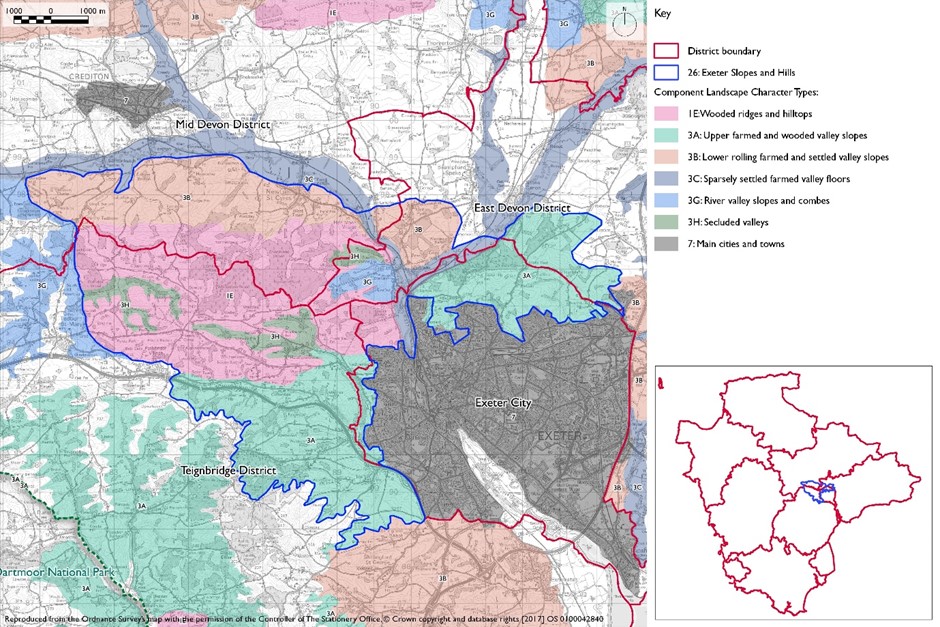
- Constituent Landscape Character Types
Constituent Landscape Character Types:
1E: Wooded Ridges and Hilltops,
3A: Upper Farmed and Wooded Valley Slopes,
3B: Lower Rolling Farmed and Settled Valley Slopes,
3C: Sparsely Settled Farmed Valley Floor,
3H: Secluded ValleysPart of National Character Area:149: The Culm
- Contextual description
 This area comprises the farmed and wooded slopes to the north and west of the city of Exeter, forming an important backdrop to the conurbation. The incised and constrained valley of the River Exe passes to the east of the hills and contains the rail and road links into the city from the north – this landscape therefore strongly influences northern approach routes to the city. The boundary of this area to the north is abrupt where the River Exe joins the Culm and the valley floor opens out to form the Culm and Exe Lowlands. To the south the boundary is the urban edge while to the east and west there is a gradual transition in character to the Clyst Lowland Farmlands and the elevated rolling hills of the Yeo Uplands and Slopes respectively.
Summary Description
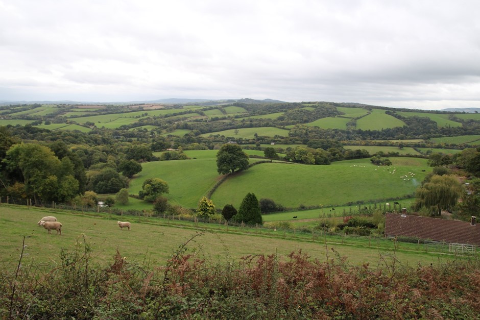
This area has a varied topography, rising to the north-west to around 248m around Waddles Down Cross. This landscape feels elevated above surrounding areas, offering views across Exeter city and the Exe estuary as well as to Crediton, Dartmoor and Haldon Ridge in the distance. Areas of steep slopes, particularly those that face northwards, are well wooded with plantation and ancient semi-natural woodland – Stoke Wood being particularly important for recreation. Within the narrow and tightly enclosed valleys the character is more intimate. Distinctive views, strong topography, notable woodland and proximity to Exeter contribute to a strong sense of place. Despite the proximity to Exeter this landscape has a strongly rural character with increasing tranquillity and sense of remoteness in the small intimate valleys as well as further west away from the urban fringe and A30 corridor.
- Distinctive Characteristics
- Predominantly sandstone with some shales, grits and cherts, giving rise to a strong varied topography of steep hills and tightly enclosed, intimate small stream valleys.
- Steep-sided gorge where River Exe breaks through these hills.
- Concentrations of woodland on high ground and steep slopes (both plantations and ancient semi-natural broadleaved woodland) e.g. fringing Haldon Ridge, Stoke Woods to the north and Whiptail, Whitestone and Newton Woods further west.
- Loamy brown soils providing moderate agricultural land quality supporting mainly pasture in the west and arable in the east.
- Irregular medieval field patterns, small to medium in scale and larger to the south, delineated by a mature hedgerow network with some hedgerow trees, interspersed by small woodland copses.
- Mixed farming patterns with a higher concentration of arable in the south.
- Semi natural habitats of semi-improved neutral grassland, mixed and broadleaved woodland, small streams and hedgerows.
- Historic features including historic sites located strategically on high land above the Exe/Culm confluence and historic settlements such as Ide.
- Small villages, hamlets and farmsteads with many vernacular buildings and clusters of modern residential and industrial along the A30 corridor.
- Settlements connected by a network of sometimes sunken, winding lanes along valleys or more open straight roads along ridges.
- Vernacular buildings of stone and render, slate and thatch.
- Open long distance views in places to Haldon Ridge, Exeter and the Exe estuary as well as northwards across the Crediton trough and west to Dartmoor.
Evaluation
- Special Qualities and Features
- Strong rural character, with woodlands, fields, hedgerows and vernacular settlements, giving rise to high scenic quality and providing an attractive setting to the city of Exeter.
- The contrast between elevated open views and inner valleys with intimate character emphasised by the presence of woodlands.
- Intermediate sense of visual enclosure – in places, the elevated nature of the landform facilitates long distance panoramic views across the landscape, with glimpsed views towards the Exe Estuary and coast. In other locations, patches of woodland and the rolling nature of the topography provide an intermittent sense of enclosure.
- Generally high intervisibility with adjacent LCAs. Due to the elevated nature of this LCA and the pattern of woodlands which punctuate the skyline, this landscape tends to be visually prominent within views from adjacent LCAs, both within and outside the District.
- Strong sense of tranquillity and dark night skies to the west, but reduced close to the A30 corridor and the urban edge of Exeter.
- Many nature conservation designations (SSSIs and CWSs) comprising neutral grassland and semi-natural/ancient broadleaved woodland, as well as three LNRs (Alphington-Whitestone Valley Park, Barley Valley, Belvidere Meadows).
- SMs at Stoke Hill Camp (hillfort), Roman signal station north of Exeter and earthwork enclosure north of Cowley, reflecting the historic strategic importance of the hills overlooking the Exe/Culm confluence.
- High value for recreation in close proximity to the city.
Forces for Change and Their Landscape Implications
- Past and Current
- Gradual ‘gentrification’ and suburban influences, eroding the historic and rural character.
- Recreational pressures leading to demand for urban fringe land uses such as golf courses, country parks with associated planting, and infrastructure.
- Hedgerow removal on more elevated land in the drive for agricultural intensification.
- Poor hedgerow management resulting in gappy hedgerows particularly on lower-lying slopes and close to the urban edge.
- A30 corridor and associated unsympathetic development eroding local perceptions of peace and tranquillity.
- Prominent telecommunications masts e.g. Waddles Down.
- The past planting of large conifer plantations, some of which break the skyline and are visually dominant.
- Urban extension beyond Exeter.
- Current pressure for increased landfill capacity to accommodate inert waste from development sites on steep or undulating topography.
- Pressure for new solar farms and masts.
- Need for farms to have slurry tanks in response to new waste management regs – increasing industrialisation of farmsteads.
- Future
- Potential road improvements and roadside developments along the A30, leading to further urbanisation along the road corridor and erosion of rural character.
- Potential new large-scale built development on elevated open ridges or slopes, which could be out of scale and highly visible and require further infrastructure.
- Potential agricultural intensification, which may lead to a loss of traditional field boundaries and a change to existing landscape pattern as well as new large scale farm buildings and industrial-style slurry tanks that are potentially not in scale and character of traditional farmsteads.
- Potential new built development, including residential expansion on the edge of Exeter which could be highly visible within this elevated landscape and require further infrastructure.
- Pressure for new masts and wind turbines, communication towers and pylons, which would be highly visible on prominent skylines.
- Pressure for new solar farms on visually prominent valley sides and hill tops which could have a very high visual impact on this elevated landscape.
- Potential new leisure and recreation developments (associated with Exeter), which would affect the predominantly rural character of this landscape and overall strong sense of tranquillity throughout.
- Demand for renewable energy schemes, including wind turbines and solar arrays, particularly on south-facing slopes.
- Conversion of traditional agricultural buildings and land for domestic and leisure use, potentially bringing unsympathetic boundary and surfacing treatments and erosion of rural character.
- Widening and new access points to narrow lanes, eroding their rural character.
- The change /transition to the new land management system (ELMS) promises to be positive for the environment- more so than the CAP- and offers opportunity to strengthen landscape features and characteristics. Need for landfill/landraising within construction sites and modification of natural topography.
- Need for attenuation basins as part of SuDS as a requirement of new development.
Strategy
- Overall Strategy
To protect the landscape’s strong rural character and role as setting to Exeter; and to protect the area’s historic features and settlement patterns. Woodland habitats and grassland habitats are managed and expanded with opportunities for green infrastructure links into Exeter being identified, safe-guarded and pursued. Historic sites are protected, managed and where appropriate interpreted for recreation.
Guidelines
- Protect
- Protect important views to and from the hill tops and ridgelines surrounding the city of Exeter.
- Protect the landscape’s dark night skies in the west by resisting highway improvements and lighting schemes.
- Protect the landscape’s rural character in close proximity to urban areas by resisting piecemeal urban expansion and recreational developments which undermine landscape patterns and sense of place.
- Protect the character of rural lanes, minimising road widening and signage in association with new development.
- Protect and appropriately manage nationally important historic/ archaeological sites and provide interpretation where appropriate to express the individual and group value strategic sites above the Exe valley.
- Manage
- Manage and enhance the valleys’ semi-natural woodlands through appropriate traditional techniques including controlled access by livestock to promote natural regeneration.
- Explore opportunities for community utilisation of woodland products as a low-carbon fuel source.
- Manage existing pattern of field enclosure and enhance the network of hedgerows by encouraging traditional hedgerow management practices including the restoration of lost and gappy hedgebanks.
- Manage semi-improved neutral grassland through appropriate grazing and traditional land management regimes.
- Manage the area’s existing plantations for sustainable timber production and wildlife interest, creating new green links to surrounding semi-natural habitats.
- Manage areas of semi-natural habitat. Link and extend habitats where possible to increase biodiversity, contribute to nature recovery networks and provide suitable habitats for flora and fauna.
- Pressure for new solar farms and masts.
- Plan
- Plan to ensure the sensitive location of new development where they contribute to the landscape setting and particularly new urban extensions of Exeter, avoiding prominent open ridges and slopes.
- Plan to screen visually intrusive sections of the A30 corridor, to limit the impact of noise and movement on the surrounding landscape.
- Plan to ensure the sensitive location of prominent tall vertical developments (such as telecommunication masts and wind turbines), avoiding prominent skyline locations which are valued as a rural backdrop to the city of Exeter.
- Plan to ensure the sensitive siting of solar farms so that these can be sited in appropriate locations and their impacts mitigated through careful design. For guidance on how to take landscape sensitivity into account and ensure good siting and design see DLPG Advice Note 2.
- Plan for a network of green spaces and green infrastructure links to support the current and future population of Exeter whilst integrating new development into the landscape.
- Plan to conserve and enhance the existing small-scale, low-density settlement pattern of hamlets and farmsteads;
- Plan to mitigate climate change impacts allowing natural process to take place where possible.
- Plan a landscape-led response to the UK-wide policy drive for increased tree and woodland planting, implementing Devon Local Nature Partnership’s ‘Right Place, Right Tree’ principles to create a balance of climate-resilient native species appropriate to the local landscape.
- Plan to contribute to nature recovery networks and provide suitable habitats for flora and fauna.
- Ensure any new development – particularly within 5km of Dartmoor National Park – is sensitive in terms of its design and scale and impacts on the naturalistic/tranquil qualities, dark skies and wildlife are minimised.
- Plan for new slurry tanks to be grouped with other farm buildings, recess into ground, use natural topography and trees for screening and integration and sensitive colour treatment with dark recessive colour to minimise visual impact.
- Plan to ensure a cut and fill balance from new development to ensure no export of waste soils to landfill. Where new or extended landfill is needed, ensure the landform restoration design respects the character of the distinctive natural topography avoid artificial engineered landforms, and integrate into the landscape.
- Plan for attenuation basins as part of SuDS required as part of development designing for biodiversity and amenity enhancement, where possible to enhance development not just provide engineering function.