Devon continues to deal with the aftermath of Storm Ingrid last weekend and Storm Chandra during the week that together caused widespread flooding, travel disruption, and damaged the county’s highways network.
Devon County Council (DCC) Flood reconnaissance teams, working with district councils and the Environment Agency, are still assessing the hardest-hit areas.
So far, more than 80 properties have been confirmed flooded across over 30 locations, with numbers expected to rise as further reports come in.
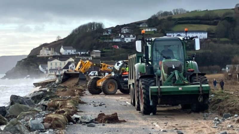
Throughout the week, roads in East, Mid, and South Devon were particularly affected, with many routes impassable by deep floodwater.
Major roads such as the A30 near Ottery St Mary, the A3052, and several local routes were closed, and emergency services rescued stranded motorists in places like Axminster and Newton Poppleford. The disruption has also hit schools hard, with over 80 closed or partially closed on Tuesday alone due to flooding.
In just one day DCC received more than 200 calls reporting issues on the roads – and responded by mobilising hundreds of highways engineers across the county.
Additional resources have been drafted in and there are around 50 teams working to repair potholes and highway damage, which have increased dramatically because of the recent weather. Some of this work will continue over the weekend.
There is currently a backlog of nearly 2,900 pothole repairs, all linked to the recent storms, and that number continues to rise.
An additional 1,600 reports of road damage are awaiting assessment, with inspectors handling an average of 620 public reports per day, totalling around 2,500 this week.
The public is encouraged to report defects online, but they are asked not to submit repeat reports for the same location, as this can slow the response to other critical areas.
In just one day DCC received more than 200 calls Flood risk management teams are also gathering information from affected communities and is urging residents to report flooding and road issues online forms and its customer service centre.
During the week, the River Otter at Ottery St Mary reached one its highest recorded levels, prompting a rare severe flood warning and leading to evacuations and property damage. Emergency services have rescued people from vehicles trapped in floodwater, and several communities have faced significant disruption, with some residents cut off and businesses, such as riverside cafés, flooded.
The Environment Agency warns that with the ground saturated river levels are expected to remain high for some time.
And the unsettled weather is set to continue. The Met Office forecasts that from today, Friday 30 January, through Saturday 31 January, another band of rain will bring up to 20mm of rainfall widely, with up to 30mm possible in places, and further flooding is possible.
Sunday is expected to be mainly dry but further rain likely on Monday and Tuesday, The Flood Guidance Statement remains at amber and yellow for rivers and surface water flooding through the weekend.
Councillor Dan Thomas, Cabinet Member for Highways, said:
“Our teams are working hard to keep Devon moving and to support communities affected by flooding. The scale of the challenge is immense, with thousands of potholes and road defects caused by the recent storms. We’re prioritising the most urgent repairs and continuing to work closely with our partners to ensure the safety of residents and road users. We urge everyone to take extra care, avoid driving through floodwater, and report any issues to the council as soon as possible. However please avoid reporting the same problem in the same area more than once as it could impact on how quickly we can respond to critical issues.”

Residents are reminded to be alert to fallen trees and branches, especially on minor roads, and never to drive through floodwater or swollen streams.
Allow extra time for journeys, reduce speed, and drive according to the conditions. Never assume a road has been salted, as rain can wash salt away, leaving roads prone to ice.
For updates, listen to local radio and follow @DevonAlert on X (Twitter) and Facebook. Flooding to property can be reported via the County Council’s online Flood Reporting Form, and more information is available on Devon County Council’s winter travel webpages.
For the latest flood warnings and alerts, visit https://check-for-flooding.service.gov.uk/location/devon.