Consultation
South West Exeter electricity substation
From
18/01/2021
Until
01/03/2021
Devon County Council (DCC) is proposing to deliver an electricity substation to support the South West Exeter (SWE) development project and is seeking your views on the proposed options.
SWE is a development of 2,500 dwellings which requires a significant amount of infrastructure to support it. This includes the delivery of the identified substation.
Without this substation, it is understood that there is insufficient electricity capacity in the area to support the full development. This would also impact future development proposals, including proposals in Exeter City Council’s ‘Liveable Exeter’ project.
The proposed electricity substation involves connecting to the existing 132kV overhead cables and is a significant piece of infrastructure.
Prior to determining the need for a substation, alternative options were considered, including 11kV and 33kV connections, which involved connections to existing substations. Advice received from Western Power Distribution (WPD), which is responsible for the electricity network in the area, was that there is insufficient capacity within the existing network to enable such connections.
In addition to supporting future development proposals, delivery of a new substation will increase the resilience of the network.
Site selection requirements
There are a number of key requirements that need to be met for a site to be suitable for a substation. These have been informed by discussions with WPD and are that the site:
- must measure a minimum of 100 metres x 70 metres
- must be in very close proximity to the 132kV network
- must be level or able to be levelled
- requires good access for large construction equipment and construction materials and 24/7 access for maintenance once developed
In addition, to minimise the disruption and cost associated with future connections, the site should be in close proximity to SWE and areas of existing and potential future development
Option development
DCC has carried out a search for land in the SWE area which meets the site selection requirements and may be suitable for the delivery of this electricity substation.
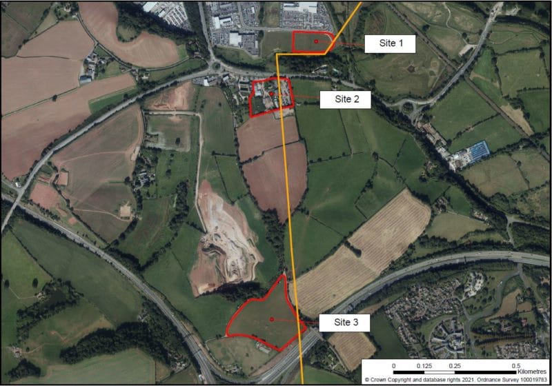
The map below illustrates the three potential sites that have been identified in the context of the SWE area.
The map shows that site 1 is located in Marsh Barton, site 2 is located at Matford Home Farm and site 3 is located at Old Matford Lane.
Also shown is the location of the existing 132kV overhead cables illustrating that these cables run close to each of the 3 sites.
More detailed information relating to each of the three sites is available below.
In arriving at these three potential sites, DCC has tried to minimise the impact of the substation on existing properties, the number of dwellings deliverable at SWE and the area identified for the delivery of Suitable Alternative Natural Green Space (SANGS).
Site 1: Marsh Barton
Background
This site measures approximately 1.2 hectares and is accessed via Marsh Barton and Matford Way. The site has planning permission (10/0200/OUT) for mixed employment uses.
The site is located in a low lying area of the south eastern corner of the existing Marsh Barton industrial estate. It is bordered by existing employment uses to the north and west, residential properties and the Matford Brook to the south and a County Wildlife Site/area of flood storage to the east.
Key constraints
The key constraint relating to this site is its location within Flood Zone 3. In order to avoid potential flooding over the operational life of the substation, it would need to be raised up to 1.88mAOD above the levels of the Matford Way footpath to the north of the site.
Due to the site’s location within Flood Zone 3, this site would not be developable unless there are no available alternatives.
Potential difficulties with access during a flood.
Proximity of nearby residential properties to the south/south east.
Key opportunities
The 132kV network runs parallel to the southern boundary of the site and crosses the south eastern corner.
This site is located in close proximity to the development at SWE and potential future development (for example, development at Marsh Barton identified as part of Liveable Exeter).
Therefore it would be relatively easy to make new connections in the future.
Flood issues aside, the site has good access from MatfordWay.
Low landscape and visual impact.
Site 2: Matford Home Farm
Background
This site comprises previously developed land at Matford Home Farm. The site measures approximately 2.1 hectares and benefits from two accesses on to the A379, one of which is via Old Matford Lane.
There are existing residential properties adjacent to the site’s western boundary and a single property is located in the centre of the site (within the existing planning application this single property is to remain –see below).
There is further planned residential development on the land immediately to the south and east of the site.
Key constraints
The site is allocated in the Teignbridge Local Plan as mixed-use development. This is likely to primarily comprise retail and employment development. An Outline Planning Application (15/00921/MAJ) for demolition of existing buildings and the development of land for residential and retail uses has been approved by Teignbridge District Council.
Proximity of nearby existing and planned residential properties.
The landscape and visual impact is expected to require mitigation.
Key opportunities
This site is located in close proximity to the development at SWE and potential future development (for example, development at Marsh Barton identified as part of Liveable Exeter) and therefore it would be relatively easy to make new connections in the future.
The 132kV network crosses the centre of the site (north/south). It is understood that the development proposed would involve either the undergrounding/rerouting of at least some of the existing cables or movement of these cables on to poles.
The site has good access from the A379.
Site 3: Old Matford Lane
Background
This site comprises approximately 4.6 hectares of agricultural land accessed from Old Matford Lane, which is a single-track road with limited passing places.
The site sits in an elevated position on a hilltop and is bordered by the M5 to the south east, the A30 to the south west, Trood Lane inert waste landfill to the north west and agricultural land to the north east.
Key constraints
The site and surrounding land to the north east/north west are allocated as Suitable Alternative Natural Green Space (SANGS) in the Teignbridge Local Plan. The SANGS is a requirement for delivery of development in the area.
The site is located approximately 350 metres south of the nearest planned future development and significantly further from other likely areas of future development. Making additional connections to this site in future would likely require large scale excavation works, potentially through the area allocated for SANGS.
Two telecommunications masts are located within the site. Further studies would be required to understand if any interference is likely.
The site access is a narrow, single-track road with few passing places. This may cause significant issues during construction.
The site is part of a designated County Wildlife Site (CWS).
Key opportunities
The 132kV network crosses the eastern corner of the site.
The site is remote from the majority of existing residential properties. The nearest being over 120 metres south west of the site boundary.
Some areas of the site would have a low landscape and visual impact.
Have your say
Please provide your views on the options shown, any alternative sites that may be suitable based on the site selection requirements or any other general comments.
Feedback can be provided until 1 March 2021 by either emailing swexeter@devon.gov.uk or by writing to Planning, Transportation and Environment, Devon County Council, Room 120, County Hall, Exeter, EX2 4QD.
If you require more information or a different format, please email swexeter@devon.gov.uk or write to the above address.
You can find more general information regarding SWE on the SWE project website and the Teignbridge District Council planning webpages.
What happens next
Following the close of the public consultation, the project team will review responses with the aim of establishing an understanding of local and other key stakeholder opinions.
Suggested changes will be considered in the further development of the proposals to inform a preferred scheme option.
A planning application relating to the preferred scheme is expected to be submitted later in 2021.