The Queen Street Pedestrian Enhancement project webpage contains up-to-date information about the progress of the scheme.
A public consultation was held between 29th April and 24th June 2022, in partnership with Teignbridge District Council (TDC), on plans for pedestrian enhancements to Queen Street, Newton Abbot. This consultation was to find out your views on the proposed changes.
Throughout the consultation, online events have taken place to allow you to speak to members of the project team. Online webinars have been held for the public and businesses where a presentation was given about the scheme; the presentation given was recorded and can be found here.
All information regarding the scheme can be found below. A Consultation Report has been published, summarising feedback received during the consultation.
Background
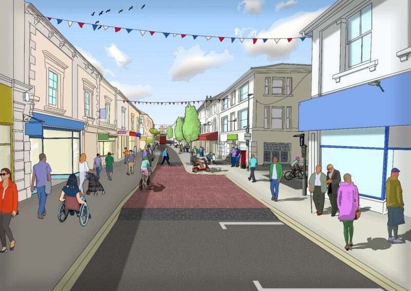
Queen Street connects Newton Abbot Rail Station to the Town Centre, and is home to an extensive number of shops, independent businesses, and services. However, currently the street is dominated by motorised vehicles, with space allocated to through traffic and on-street parking.
This means that:
- footways are too narrow in places for large numbers of pedestrians
- Queen Street and its side roads can be difficult to cross
- not enough space is allocated to pedestrians who are the priority in a Town Centre area.
A package of proposals have been designed to make Queen Street a more attractive, safe and healthy place for visitors and businesses.
In 2019, Teignbridge District Council bid for a share of £1 billion Future High Street Fund which was set up to help reshape town centres through transformational schemes.
In 2020, Teignbridge District Council hosted a consultation to engage with the public on potential plans for Queen Street.
In 2021, Teignbridge District Council were successfully awarded a portion of the Future High Streets Fund, however due to the fund being oversubscribed, it was necessary to scale the proposals back. The additional parking proposed for the Cricketfield car park was removed from the proposals as it was not deemed good value for money.
With approval from Devon County Council (DCC) elected members and in partnership with TDC, DCC is holding a public consultation to collect public feedback on the most recent plans and designs for Queen Street. This public consultation aims to understand your views on the specific improvements that will be implemented along Queen Street.
Proposals
A package of proposals have been designed to make Queen Street a more attractive, safe and healthy place for visitors and businesses. These proposals aim to make everyone feel safe and welcome, with more spaces for pedestrians to enjoy and access shops and services, improved accessibility, cleaner air and less noise and pollution.
A summary of the proposals is detailed in the table below. Scheme plans can be viewed at the links below:
- Overview scheme plan, showing exactly what is proposed where.
- Parking and loading scheme plan , showing proposed changes to on-street parking and loading bays.
Devon County Council has undertaken a significant amount of work to understand the impacts of the proposed changes on the wider transport network and parking behaviour. A summary of this work is available to view here .
An Impact Assessment has been undertaken for the proposed scheme, which can be found on the Devon County Council Impact Assessment webpage, or viewed here.
For some proposals, funding is yet to be secured for delivery, these proposals are limited but are clearly highlighted (*) in the summary table and the overview scheme plan.
Pedestrian and public realm improvements
Proposal |
Summary |
Detail |
|---|---|---|
| Widened footways | Widened footways will give pedestrians more space to move and access shops and services. Increased footway width will also improve access for mobility scooters, buggies etc. |
The focus of footway widening is at the western end of Queen Street, between Courtenay Street and Albany Street, with approximately 4m and 5m wide footways on the northern and southern side respectively. To the west of King Street, on the southern footway, a flexible loading bay will act as an extension of the footway outside loading times. The southern footways will also be widened to approximately 4m between Albany Street and the existing zebra crossing outside Bernes Primary School. |
| Improved Crossings |
Improved crossings at side roads will make junctions safer and easier to cross, with priority given to pedestrians instead of vehicles. Safer crossing opportunities will also be provided across Queen Street. |
Pedestrian priority raised tables will be provided at every side road along Queen Street, between Devon Square / Lemon Road and Hopkins Lane. This means that pedestrians will have priority over vehicles at each junction and the crossings will be level with footways. Funding is yet to be secured for Lemon Road priority table crossing (*). A narrower carriageway between The Avenue and Courtenay Street, partnered with a reduced speed limit, will make Queen Street easier and safer to cross. A new zebra crossing immediately west of the War Memorial will also provide a new formal crossing opportunity. |
| Enhanced greening and seating |
Enhanced greening and seating will contribute towards making the corridor a more appealing shopping destination. Additional street furniture etc. to be adopted by the Town Council, which maintain the existing street furniture etc. |
New in-ground tree planting is proposed on the northern footway between Courtenay Street and Albany Street. This will be complemented by the relocation of existing flower poles from the northern footway to the southern footway at the same location. A new double-headed flower pole is also proposed at the King Street junction. Between Albany Street and Prospect Terrace, two double-headed flower poles are proposed, one to the west of Fairfield Terrace and one to the west of Prospect Terrace on the southern footway. Two benches and planters are also proposed on the southern footway between Fairfield Terrace and Prospect Terrace. |
| Public Transport | A new bus lay-by is proposed, improving the quality of an existing stop. | The existing bus stop outside St Joseph’s Catholic Church will be enhanced to create a bus lay-by. The existing bus stop west of Albany Street will remain in a reduced width carriageway of approximately 3.25m. |
| Cycle Provision | A reduction in general traffic and the provision of new cycle parking will make accessing Queen Street by bike more attractive. |
Whilst cycle trips will remain westbound only from The Avenue, north/south movements will be enhanced through the removal of traffic to/from King Street and at the southern end of Lemon Road (*). A shared use path alongside the War Memorial, which leads to a new quiet route along Oak Place to Courtenay Park, is also proposed (*). The new zebra crossing west of the War Memorial has the potential to be upgraded to a parallel crossing (*), leading to onward north/south cycle links along The Avenue to Lemon Place (*). New cycle parking is proposed on the northern footway at the Lemon Road junction (*) and at the southern footway at the King Street junction. |
Changes for motorised vehicles
Proposal |
Summary |
Detail |
|---|---|---|
| Parking and Loading Changes | Parking reduction (approximately 55% across the scheme area), a small increase in disabled parking, and changes to loading bays to facilitate transformational pedestrian enhancements. |
In order to deliver transformational pedestrian and public realm improvements, approximately 55% of on-street parking is proposed to be removed. This includes the removal of all on-street parking between Courtenay Street and Albany Street, a small reduction on Victoria Place, between Albany Street and Lemon Place, between Lemon Road and The Avenue and on St Paul’s Road. However, disabled on-street parking will increase overall within the scheme area, through an increase in provision on Courtenay Street and additional space between Lemon Road and The Avenue. Space for loading will also increase in the scheme area through more space on Victoria Place and between Albany Street and Lemon Road. A flexible loading bay will be provided on Queen Street, immediately west of King Street. This will operate as an extension to the footway outside loading hours, with no kerb between the permanent footway and the loading space. Where on-street loading, outside of loading bays, is currently permitted at restricted times, under proposals loading will not be permitted at any time. |
| Traffic Removal | Removal of general traffic from the corridor is central to achieving transformational uplift for pedestrians and the public realm. General traffic removal west of Albany Street and restricted access on some side roads is proposed. |
It is proposed to restrict access on Queen Street, west of Albany Street, to buses, cycle and restricted hours loading. Taxis would be able to access this area to stop to pick up or set down passengers. Drivers of vehicles displaying a blue badge would also be able to access to stop and pick up or set down a disabled person. Through traffic will be encouraged to remain on The Avenue and general traffic accessing Queen Street will then be routed north on Albany Street when leaving Queen Street. The specification of loading hours restrictions forms part of the consultation questionnaire. There will be no motorised vehicular access between King Street and Queen Street, however, space for a turning head will be provided at the top of King Street by reducing the eastern footway width to approximately 1.5m. Hopkins Lane will be made one-way northbound. The southern end of Lemon Road will be restricted to limited northbound vehicle access only, with two-way cycle movements permitted (*). |
| Speed Limit | A reduced 20mph speed limit is proposed. | A new 20mph speed limit is proposed between The Avenue and Courtenay Street, this will further enhance the environment for visitors and enhance safety for Bearnes Voluntary Primary School. |
Have your say
This consultation is now closed. However, if you wish to speak to a member of the project team, please email us: transportplanning@devon.gov.uk
FAQs
Under the scheme proposals, there will be a significant reduction in general on-street parking. Will there still be sufficient parking in the area?
The project team understands people’s concerns about the removal of parking to achieve transformational pedestrian and public realm improvement. A significant piece of work has been undertaken to investigate existing parking demand and supply. This work can be viewed here.
Based on analysis of the numbers of parking tickets purchased, a significant number of spaces along Queen Street are unoccupied on weekdays and on Saturdays. Ticket analysis also suggests that parking bays are generally occupied for more than 20 minutes and regularly more than 40 minutes.
Whilst a significant proportion of on-street parking (approximately 45%) will remain under the proposals, there are also alternative nearby off-street parking facilities in the vicinity of Queen Street that are available for visitors and shoppers to use. This includes the Cricketfield Road car park, which is 160m away or roughly a 2-minute walk. Given the average visit to Queen Street is more than 20 minutes, the convenience and proximity of the existing car parks to Queen Street is considered reasonable. Cricketfield Road car park ticket data suggests that during peak times, the car park is used at approximately 2/3 capacity, excluding permit holder parking. This suggests that an increase in parking demand can be accommodated at car parks within a reasonable distance for most users. It should also be noted that on-street disabled parking in the scheme area will overall increase.
Residents on roads adjacent to Queen Street use the parking bays for free in the evening – where will residents be able to park if these bays are removed?
A significant number of parking spaces will remain on Queen Street, east of Albany Street, and will remain available to residents to park in overnight. Additionally, there are a number of car parks in close proximity to Queen Street, including Cricketfield Road car park, which has over 300 spaces, and is free to park in between 6pm-9am.
Where will all the traffic go under the proposals to remove traffic from Queen Street?
It is estimated the traffic flows on roads adjacent to Queen Street will see modest increases in traffic under the proposed access changes. Junction modelling has shown that the Cricketfield Road / Kingsteignton Road junction has the capacity to support the increased flow, and therefore it is unlikely that there will be significant queuing. The proposals will lead to significant traffic reduction on Queen Street itself, creating a safer environment for pedestrians and cycles and affording journey time benefits to buses.
Where will taxis be able to pick up and set down passengers?
Under proposals, the two taxi ranks currently located within the scheme area are set to removed. This was decision was made as a result of feedback from the initial public consultation, held by Teignbridge District Council in 2020. The proposals will still allow taxis to access Queen Street west of Albany Street to pick up or set down passengers.
What are the next steps for the scheme, after public consultation?
Following the close of the public consultation, responses were analysed by the project team. A public consultation report has now been published, so that everyone can see the outcomes of the consultation. Devon County Council officers will make a recommendation for next steps to the Teignbridge Highways Orders and Traffic Committee on 25th July 2022. Devon County Council councillors will then vote on this recommendation.
If you would like further information, please get in touch using the contact details below:
- Address: Transport Planning, Matford Offices, County Hall, Topsham Road, Exeter, EX2 4QD
- Phone: 0345 155 1004
- Email: transportplanning@devon.gov.uk
Accessibility
We take accessibility seriously and recognise that some of the information presented in the files available on this page may not be fully accessible to someone using assistive technology such as a screen reader. If you need guidance or an alternative format, email transportplanning@devon.gov.uk with details of any preferred format and the assistive technology you use