Consultation
Exeter Local Cycling and Walking Infrastructure Plan (LCWIP)
From
01/02/2023
Until
31/03/2023
The Exeter Local Cycling and Walking Infrastructure Plan was adopted at Cabinet in January 2024. You can view the adopted Exeter LCWIP here.
This consultation is now closed. A report summarising the consultation responses can be viewed here.
Following the consultation, the LCWIP document has been updated, this new version can be seen here.
A public consultation is being held on proposals for new and improved cycling and walking routes that will be included in the Exeter Local Cycling and Walking Infrastructure Plan (LCWIP).
The consultation will run from Wednesday 1 February to Friday 31 March.
The consultation is seeking views on the proposed network and routes to enable residents and visitors to make the majority of local journeys in and around the city on foot or by cycle.
Please read the information provided below to find out more about the proposals. For full details of all proposals, please refer to the full LCWIP draft document. The process followed to create this LCWIP is summarised in this short video.
To give feedback on the overall LCWIP network, please fill out the network feedback form or come to one of our events being held during the consultation period. Full details of these can be seen below.
Below are details of all routes that make up the LCWIP network, with optional feedback forms available for each. These forms are to provide the project team with direct feedback about details of individual routes so please select those for which you have a particular interest.
Background
The requirement for local authorities to produce a LCWIP is set out in the Government’s Cycling and Walking Investment Strategy. Developing a LCWIP follows a consistent process to identifying cycling and walking improvements required at a local level and allows Devon County Council to bid for future funding and ensure improvements are incorporated into future development.
Exeter is a compact city and Devon County Council, working alongside Exeter City Council, have a strong track record of delivering improvements to walking and cycling routes in the city. As a result of this walking levels in Exeter are consistently amongst the highest in the UK and cycling levels continue to grow.
Looking forward, the Exeter Transport Strategy 2020 – 2030 sets out the ambition for 50% of work trips originating in Exeter to be made by foot or cycle by 2030. This aim received high levels of public support during the Exeter Transport Strategy consultation.
The Exeter LCWIP will set out the infrastructure needed to enable people to change their travel habits and make progress towards the aim for 2030.
The LCWIP has followed the Department for Transport’s 6 stage process:
Stage 1 – Determine the scope
Establish the geographical context and arrangements for governing and preparing the plan.
Stage 2 – Gathering Information
Identify existing walking and cycling patterns and potential new journeys. Review existing conditions and identify barriers to walking and cycling. Review related transport and land use policies and programmes.
Stage 3 – Network planning for cycling
Identify origin and destination points and cycle flows. Convert flows into a network of routes and determine the type of improvements required.
Stage 4 – Network planning for walking
Identify key trip generations, core walking zones and routes, audit existing provision and determine the types of improvements required.
Stage 5 – Prioritising improvements
Prioritise improvements to develop a phased programme for future investment.
Stage 6 – Integration and application
Integrate outputs into local planning and transport policies, strategies, and delivery plans.
A link to the full Department for Transport guidance is available here.
This process is explained fully in this short video.
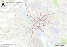
Cycling proposals
The cycle routes proposed within the Exeter LCWIP overlay existing cycle provision in the city. This is made up of a network of traffic free routes, on road lanes and advisory routes on quieter roads. Some parts of the existing network are included in the proposals and where necessary improvements have been recommended.
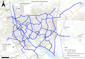
At this stage, the focus has been on ensuring routes follow the best alignment and connect where people live with the main destinations in the city. High level suggestions of the type of infrastructure have been identified but detailed design on individual routes has not yet been undertaken. As routes are progressed to detailed design, further consultation will be carried out.
To give feedback on the overall LCWIP cycling network, please fill out the network feedback form
Details of the 22 proposed routes and an opportunity to feedback can be seen below.
-
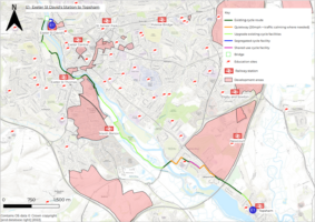
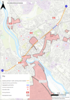
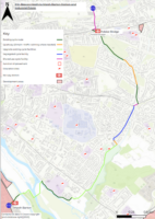
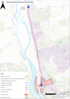
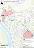
E1 - Exeter St David's Station to Topsham

Key locations along the proposed E1 cycle route 
Plan of proposed E1 cycle route (click on image to see full PDF plan) E1, or the ‘Exe Cycle Route’, is the spine of Exeter’s cycle network and the most well used route in the city for recreational and everyday journeys. The route is used for trips to Exeter St David’s station, the city centre, Exeter Quay, Marsh Barton Industrial Estate and many other journeys. Starting at Exeter St David’s Station this level route initially follows the River Exe at the Quay and then Exeter Canal as far as Bridge Road. Here it continues through the Countess Wear residential estate towards Topsham. The route is also part of the National Cycle Network – NCN34. At Bridge Road and Topsham the route becomes part of the Exe Estuary Trail (NCN2) continuing down to the coast at Dawlish and Exmouth.
The route is in place and largely comprises of shared off-road paths away from traffic. At Bridge Road the routes becomes a shared path adjacent to the carriageway and then travels on quiet roads through the Countess Wear estate. As it continues to Topsham the route is a shared path before re-joining quiet roads through the town.
Parts of the route can become busy with both pedestrians and cyclists, particularly at the weekend or during school holidays. The route doesn’t have a clear start at St David’s Station and access can therefore be difficult here. This should be picked up in measures put forward for route E18, the future Boniface Trail and through redevelopment proposed at Exeter St David’s Station as part of the Liveable Exeter ‘Red Cow’ proposals.
With other Liveable Exeter proposals at Exe Bridges, Water Lane and Marsh Barton as well as development progressing at South West Exeter this route is likely to becomes increasingly popular, particularly with the opening of Marsh Barton Station in the coming months. Some improvements are proposed in the vicinity of the station, improving connecting connection to employment at the Royal Devon and Exeter Hospital and County Hall as part of E6 and also to the Water Lane development as part of E14. Recommended works include a new walking and cycling bridge linking to Exeter St David’s, widening and improvements to existing sections of path and lighting to make the route suitable for year-round usage.
If you would like to give feedback on this route, please fill out the E1 – Exeter St David’s Station to Topsham feedback form.
-
E2 - Exminster to Pinhoe

Key locations along the proposed E2 cycle route E2 connects Exminster to Pinhoe via the Exeter outer ring road. The route passes a number of key employment and education sites including: Pynes Hill Business Park, the Met Office, St Peters School and St Lukes School. As well as linking to existing residential communities, E2 connects new developments off Cumblerland Way and at Monkerton to the Exeter cycle network.
The route is in place and comprises of shared use paths alongside Rydon Lane and Hill Barton Road. There is generally low footfall on this route, apart from in the vicinity of the school. There is some localised narrowing and passing of concealed entrances, particularly as the route approaches Countess Wear roundabout. The shared paths are adjacent to carriageway with no buffer zone as recommended in LTN 1/20.
The E2 route is substantially complete and here are no proposals to upgrade this route as part of the Exeter LCWIP. Therefore no detailed map is included here.
If you would like to give feedback on this route, please fill out the E2 – Exminster to Pinhoe feedback form.
-
E3 - City Centre to Cranbrook

Key locations along the proposed E3 cycle route 
Plan of proposed E3 cycle route (click on image to see full PDF plan) E3 runs from the city centre to the new town at Cranbrook through the heart of the residential communities of Newtown, Heavitree and Whipton. It passes a number of schools on route and connects to the new employment sites at Science Park, Sky Park and various freight depots along the old A30 as well as residential development off Tithebarn Lane before connecting to Cranbrook.
The route has already been signed in the city, largely using quieter roads and a number of modal filters have been introduced to further reduce traffic. Further work is planned to improve crossings and create sections of protected cycling provision as well as a new alternative off-road cycle route from Mosshayne Lane to Cranbrook, away from the busy London Road B3174.
If you would like to give feedback on this route, please fill out the E3 – City Centre to Cranbrook feedback form.
-
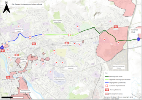
E4 - Exeter University to Science Park

Key locations along the proposed E4 cycle route 
Plan of proposed E4 cycle route (click on image to see full PDF plan) E4 connects Exeter St David’s Station to the University before continuing on through residential communities around Stoke Hill and Beacon Heath. It passes St James’s and Willowbrook School and leisure facilities at Exeter Arena before continuing past development along Cumberland Way to employment at Science Park.
Progress has been made on some sections of the E4 on Cumberland Way as far as a new bridge over Summer Lane. The remaining work comprises a mix of upgrading existing off-road paths, through parks and shared use facilities, as well as new sections of protected cycle route and the provision of dedicated cycle facilities at Stoke Hill roundabout.
If you would like to give feedback on this route, please fill out the E4 – Exeter University to Science Park feedback form.
-
E5 - Stoke Hill to St Thomas

Key locations along the proposed E5 cycle route 
Plan of proposed E5 cycle route (click on image to see full PDF plan) E5 connects the St Thomas residential area and local centre to and through the city centre, continuing on up to the Stoke Hill area where it links to the east west E4 route.
The route tackles some of the most challenging areas for cycling in the city where space is dominated by heavy traffic. These include: Cowick Street, Exe Bridges, Fore Street, Sidwell Street, St Anne’s (The Odeon) roundabout and Old Tiverton Road.
Provision is likely to be a mix of protected and off-road cycle facilities on the main roads as well as through the main junctions. Modal filters such as bus gates are also being considered to reduce the volume of general traffic on the roads where dedicated provision isn’t feasible.
If you would like to give feedback on this route, please fill out the E5 – Stoke Hill to St Thomas feedback from.
-
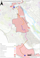
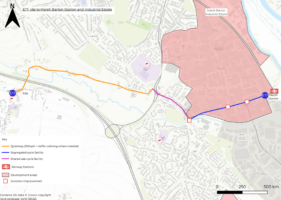
E6 - 'Nurses Way' Stoke Hill to Marsh Barton Station and Industrial Estate

Key locations along the proposed E6 cycle route 
Plan of proposed E6 cycle route (click on image to see full PDF plan) There is an absence of coherent north/south cycling routes within the city. E6 links residential areas to two of the city’s largest employers at the Royal Devon Exeter Hospital and County Hall as well as linking with routes to the new Marsh Barton Station and Industrial estate.
The route follows a number of busy roads in the city and so protected provision is needed, including through junctions. Lighting is proposed from Marsh Barton Station, making the route suitable for year-round usage.
If you would like to give feedback on this route, please fill out the E6 – ‘Nurses Way’ Stoke Hill to Marsh Barton Station and Industrial Estate feedback form.
-
E7 - Exeter St David's Station to Exeter Quay

Key locations along the proposed E7 cycle route 
Plan of proposed E7 cycle route (click on image to see full PDF plan) E7 is a direct and level route from Exeter St David’s Station to Exeter Quay allowing people on cycle to avoid lengthy alternative routes and traffic on Exe Bridges and Bonhay Road. The route will form a useful alternative connection from the future Liveable Exeter developments at Water Lane and West Gate. The proposals at Exe Bridges will also benefit pedestrians and improve access to the important historical ruins of the medieval Exe Bridge dating back to the 12th Century.
There is some existing cycling infrastructure on Bonhay Road but it is not connected and requires review. There are however high traffic flows and some physical constraints that may limit potential design options. The main work at Exe Bridges will be reviewing traffic signal design at key junctions to incorporate pedestrian/cycle phases. This may require the filling in of one of the existing subways to provide the necessary space. Additional works will require the creation of some sections of shared use path.
If you would like to give feedback on this route, please fill out the E7 – Exeter St David’s to Exeter Quay feedback form.
-
E8 - Wonford to Sowton Industrial Estate

Key locations along the proposed E8 cycle route Plan of proposed E8 cycle route (click on image to see full PDF plan) Route E8 is a shorter route connecting the residential community in the Rifford Road, Wonford/St Loyes area to employment at Sowton Industrial Estate whilst also passing St Peter’s Church of England secondary school. Although this is a relatively short route, data shows that there are currently a large number of car trips that could potentially be replaced by cycle journeys if there was improved provision.
Proposed works would see the creation of dedicated protected cycle provision on Quarry Lane with a modal filter close to the school to reduce vehicular traffic in the area. There is a major challenge on this route on Sidmouth Road where the alignment goes under a tight railway arch that has no pedestrian/cycle provision and high traffic flows.
If you would like to give feedback on this route, please fill out the E8 – Wonford to Sowton Industrial Estate feedback form.
-
E9 - Topsham / Newcourt to City Centre via Wonford and St Leonards

Key locations along the proposed E9 cycle route 
Plan of proposed E9 cycle route (click on image to see full PDF plan) E9 connects the city centre with a number of Exeter’s largest employment sites at Devon County Council, the Royal Devon and Exeter Hospital and Pynes Hill Business Park as well as the growing Newcourt residential development and the historic town of Topsham. The route travels through the existing residential areas of St Leonards and Wonford linking into the local area centre of both communities.
As well as being used for longer journeys, this route is likely to be popular for local shorter trips from home to the shops or to work.
From a leisure perspective the route also opens up the Ludwell Valley Park to cycling and creates a warmer welcome from the Wonford Playing Fields.
E9 uses a number of residential roads where it is not feasible to provide dedicated protected cycle infrastructure. In these areas modals filters, junction narrowing, and traffic calming are being used to reduce the volume and speed of traffic which will have the additional benefits of improving the sense of community in these areas.
If you would like to give feedback on this route, please fill out the E9 – Topsham / Newcourt to City Centre via Wonford and St Leonards feedback form.
-
E10 - Pynes Hill Business Park to Sowton Industrial Estate and Exeter Business Park

Key locations along the proposed E10 cycle route 
Plan of proposed E10 cycle route (click on image to see full PDF plan) E10 creates a linking route to and through employment sites at Pynes Hill, Sowton and Exeter Business Park that can be used for commuters getting to and from work as well as journeys between businesses throughout the day. It also passes through the residential communities at Clyst Heath, close to Digby and Sowton Station and through the retail park at Exeter Vale.
Some sections of E10 are in place, largely consisting of shared use paths with low levels of pedestrian movement. Work has recently been undertaken to deliver cycle lanes along Russell Way to remove a missing link.
Proposals include providing dedicated pedestrian / cycle crossings at the busy Moor Lane roundabout and removing the missing links on the path along Moor Lane. There is also scope to improve the feeder route through Sowton Industrial Estate along Kestral Way and Bittern Road.
If you would like to give feedback on this route please fill out the E10 – Pynes Hill Business Park to Sowton Industrial Estate and Exeter Business Park feedback form.
-
E11 - Pynes Hill Business Park to Westpoint Arena

Key locations along the proposed E11 cycle route Route E11 runs from Pynes Hill Business Park to Westpoint Arena passing through the Clyst Heath residential area, Sowton Industrial Estate and then the village of Clyst St Mary. Future development is likely in this area of East Devon and high-quality provision will be essential to make cycling an attractive option.
Existing provision is in place for much of this route, but it is substandard for large parts. Future works are likely to comprise of widening existing shared provision and providing buffers from fast moving traffic on the A3052.
The E11 route is substantially complete and here are no proposals to upgrade this route as part of the Exeter LCWIP. Therefore no detailed map is included here.
If you would like to give feedback on this route, please fill out the E11 – Pynes Hill Business Park to Westpoint Arena feedback form.
-
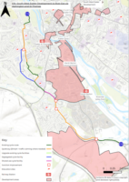
E12 - Beacon Heath to Marsh Barton Station and Industrial Estate

Key locations along the proposed E12 cycle route 
Plan of proposed E12 cycle route (click on image to see full PDF plan) E12 closely follows the alignment of Exeter’s Northbrook watercourse. As a result, for a hilly city the route is comparatively flat.
There is an absence of coherent north/south cycling routes within the city. This strategic route links residential areas to key employment sites at the Royal Devon and Exeter Hospital as well as linking with routes to the Marsh Barton estate. In addition, the route could be used as part of education journeys to a number of primary and secondary schools in the city.
Many of the recommendations are upgrades to existing provision and seek to deliver a route of consistent quality with improved attractiveness and natural wayfinding. Lighting is proposed to make the route suitable for year-round usage.
If you would like to give feedback on this route, please fill out the E12 – Beacon Heath to Marsh Barton Station and Industrial Estate feedback form.
-
E13 - Clyst St Mary to Topsham via Clyst Road

Key locations along the proposed E13 cycle route 
Plan of proposed E13 cycle route (click on image to see full PDF plan) E13 follows Clyst Road connecting Topsham to Clyst St Mary. Development is taking place on Clyst Road, and further development is likely to take place in this area of East Devon. In addition, the Exeter Chiefs rugby ground at Sandy Park is an important trip attractor on match days.
There is currently no dedicated walking and cycling provision on Clyst Road and it is likely to become increasingly busy with traffic.
Off-road cycling and walking provision is recommended in this area as well as ensuring consistent speed limits are in place.
If you would like to give feedback on this route, please fill out the E13 – Clyst St Mary to Topsham via Clyst Road feedback form.
-
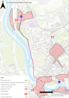
E14 - Marsh Barton Station to city centre via Water Lane development and Exeter Quay
Key locations along the proposed E14 cycle route 
Plan of proposed E14 cycle route (click on image to see full PDF plan) E14 will connect the future Liveable Exeter sites at Marsh Barton and Water Lane to leisure opportunities at Exeter Quay and onwards to the city centre as well as link to the new Marsh Barton rail station.
Proposed works would see upgrading and lighting of a route along Exeter Canal making it attractive for year-round usage as well as removing some of the missing links on route. At Exeter Quay there is a need to replace Mallison Bridge, allow contraflow cycling on Quay Hill and improve the connection to the city at South Street via the subway to Coombe Street.
If you would like to give feedback on this route, please fill out the E14 – Marsh Barton Station to City Centre via Water Lane development and Exeter Quay feedback form.
-
E15 - South West Exeter development to Exe Bridges

Key locations along the proposed E15 cycle route 
Plan of proposed E15 cycle route (click on image to see full PDF plan) E15 will connect from the new school and residential development at South West Exeter via a new pedestrian / cycle bridge over the A379 through Alphington and the Marsh Barton Industrial Estate to the cycle network at Exe Bridges. The route will also link through the proposed Marsh Barton Liveable Exeter site.
The route will comprise of a new bridge over the A379 and off-road cycle routes to the bridge as well as some junction improvements to provide protected cycling provision linking into segregated cycle lanes. Sections of the route will also be on carriageway quiet lanes where traffic volumes and speeds are low.
If you would like to give feedback on this route, please fill out the E15 – South West Exeter development to Exe Bridges feedback form.
-
E16 - South West Exeter development to River Exe via Alphington and St Thomas

Key locations along the proposed E16 cycle route 
Plan of proposed E16 cycle route (click on image to see full PDF plan) Route E16 connects the new South West Exeter residential development at Matford to the Exe cycle route (E1) at Flower Pots playing fields via the existing residential communities of Alphington and St Thomas as well as passing West Exe College.
The proposed route links together existing sections of shared use provision with new sections of protected cycle lanes on Cowick Lane and quiet lanes on Dawlish Road and Wardrew Road made possible by modal filters. An alternative alignment is also possible via the existing cycle route through Cowick Barton Playing Fields and Barton Road.
If you would like to give feedback on this route, please fill out the E16 – South West Exeter development to River Exe via Alphinton and St Thomas feedback form.
-
E17 - Ide to Marsh Barton Station and Industrial Estate
Key locations along the proposed E17 cycle route 
Plan of proposed E17 cycle route (click on image to see full PDF plan) E17 connects the village of Ide to employment at Marsh Barton, the new Marsh Barton railway station and the city network. There is currently a lack of coherent safe cycle provision through Marsh Barton and with high traffic volumes it is off-putting to all but the most confident cyclists.
This route comprises of a recently delivered quiet route made possible with a modal filter on Balls Farm Road as well as dedicated provision through Alphington and Marsh Barton. Works are likely to comprise a mix of shared use provision and protected lanes through Marsh Barton. Junction improvements are needed throughout Marsh Barton to deliver this route.
If you would like to give feedback on this route, please fill out the E17 – Ide to Marsh Barton Station and Industrial Estate feedback form.
-
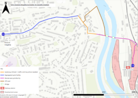
E18 - Exwick Heights to Exeter St David's Station

Key locations along the proposed E18 cycle route 
Plan of proposed E18 cycle route (click on image to see full PDF plan) E18 will deliver an improved connection from the Kinnerton Way residential area of Exwick to Exeter St David’s station and onward journeys on the proposed future cycle network. There is currently a lack of cycling provision in Exwick, in part due to the hilliness of the area. The increasing popularity of E-cycles removes some of the effort needed and presents an opportunity to create some high-quality direct cycle routes.
Opportunities include potential protected cycle provision on Kinnerton Way and an improved off-road connection to Station Road through open space alongside the Exe Flood Defence Scheme. Major works are required on Station Road with the potential for new walking/cycling bridges which will have the added benefit of improving connections from Exeter St David’s Station to the Exe cycle route/ Exe Estuary Trail and the potential future Boniface Trail linking to Crediton.
If you would like to give feedback on this route, please fill out the E18 – Exwick Heights to Exeter St David’s Station feedback form.
-
E19 - Cowley Bridges to Exeter St David's Station

Key locations along the proposed E19 cycle route 
Plan of proposed E19 cycle route (click on image to see full PDF plan) E19 runs along Cowley Bridge Road from the Cowley Bridge roundabout to Exeter St David’s Station. This linear route would connect residential and student accommodation as well as education sites to the Exeter cycle network.
Cowley Bridge Road is a busy strategic route into the city for traffic travelling from the Crediton and Tiverton direction. There are some challenging sections where the highway is narrow and bounded by walls with limited opportunity to deliver high quality provision.
Previous design work has been carried and identified scope for a shared use pedestrian / cycle route along Cowley Bridge Road. This could be reviewed using the latest design guidance to understand what is feasible in this challenging space.
If you would like to give feedback on this route, please fill out the E19 – Cowley Bridges to Exeter St David’s Station feedback form.
-
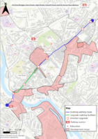
E20 - Exeter St David's Station to South Street via Iron Bridge

Key locations along the proposed E20 cycle route 
Plan of proposed E20 cycle route (click on image to see full PDF plan) E20 connects Exeter St David’s Station to the southern end of the city centre at South Street and the future ‘South Gate’ Liveable Exeter site. There is also a Liveable Exeter site ‘Red Cow’ at St David’s Station that will also benefit from this route.
Cycling connections from the city centre to Exeter St David’s Station area are currently poor with high traffic levels in the area. This route will comprise a redesign of the double mini roundabouts at the bottom of St David’s Hill as well as protected lanes on St David’s Hill itself. Iron Bridge Road has already become a quiet route with the recent modal filter here reducing traffic in the area. A cycle contra-flow on South St will complete this route creating a more direct connection to the city centre than is currently possible.
If you would like to give feedback on this route, please fill out the E20 – Exeter St David’s Station to South Street via Iron Bridge feedback form.
-
E21 - Exeter St David's Station to city centre via Queen Street

Key locations along the proposed E21 cycle route 
Plan of proposed E21 cycle route (click on image to see full PDF plan) E21 is a spur route off route E20. This route will improve cycling and walking connections from the heart of the city centre to Exeter St David’s Station. With the future Liveable Exeter site at ‘Red Cow’ this will be an important link.
Works will provide dedicated provision on Hele Road and a potential remodelling of the Queen St / Clock Tower junction, reclaiming this historic monument to create an improved public space. Queen St has already had some recent improvements as part of DfT Emergency Active Travel Funding but further work is needed to reduce the dominance of traffic on this environment and provide improved provision for pedestrians and cyclists.
If you would like to give feedback on this route, please fill out the E21 – Exeter St David’s Station to City Centre via Queen Street feedback form.
-
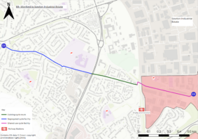
E22 - Newtown to Water Lane development via St Leonards

Key locations along the proposed E22 cycle route 
Plan of proposed E22 cycle route (click on image to see full PDF plan) Route E22 will create an improved link from the residential communities of Newtown and St Leonards to leisure opportunities along the River Exe and employment at Marsh Barton. It would also link the future Marsh Barton and Water Lane Liveable Exeter sites to the city centre, St Leonards Primary School and St Lukes University campus.
The main works would be a new bridge over the Exeter Canal to create a more direct link in the area and then some localised improvements along the Exe cycle route. In St Leonards a potential modal filter on St Leonard Road would reduce through traffic in the area and also have scope to reduce school run traffic. A junction upgrade between College Road and Gladstone Road across Heavitree Road is also needed to accommodate right turning cycles out of College Road.
If you would like to give feedback on this route, please fill out the E22 – Newtown to Water Lane development via St Leonards feedback form.
-
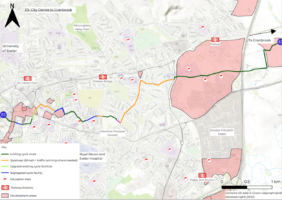
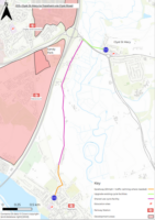
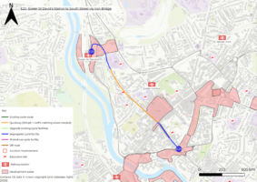
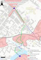
W1 - Exeter Quay / Haven Banks to city centre via South Street

Plan of proposed W1 walking route (click on image to see full PDF plan) This route is focussed on improving the connection between Exeter’s historic Quayside and the city centre. With major new residential development proposed at Water Lane and Exeter Quay’s status as one of the city’s top visitor destinations, it’s important that there is an easy to use, coherent, safe and attractive route for people to walk and wheel.
At the Quay, proposals include upgrading the connection from Cricklepit Bridge to Commercial Road and the replacement of Mallison Bridge. An environmental enhancement is recommended to refresh the connection from Quay Hill to Coombe Street via the subway improving perceptions of safety and making this important gateway more attractive and intuitive. Junction improvements will make it easier to cross South Street and Market Street and there is scope to investigate an enhancement scheme on South Street, reallocating carriageway and reducing the dominance of vehicles. This will tie into redevelopment proposed in the Gate area.
These proposals have synergies with cycling improvement proposed as part of routes E14 and E20.
If you would like to give feedback on this route, please fill out the W1 – Exeter Quay/Haven Banks to city centre via South Street feedback form.
-
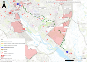
W2 - Exe Bridges, Fore Street, High Street, Sidwell Street and St Annes roundabout

Plan of proposed W2 walking route (click on image to see full PDF plan) This linear route will improve connections from the residential areas of St Thomas and St James as well as making improvements to the retail heart of the city along Fore Street, High Street and Sidwell Street.
At Exe Bridges, pavement level signal crossings allowing people a direct, attractive, alternative to the subways are suggested. A major review is also proposed at St Annes roundabout to prioritise and make pedestrian and cycle movements more direct. A number of other junctions have been put forward to review including at Mary Arches Street, North Street / South Street and at York Road. On Fore Street there is scope to improve side road priority for people walking and wheeling and for a wider review of traffic circulation that could allow carriageway space to be reallocated to widen footways.
These proposals have synergies with cycling improvements proposed as part of routes E5 and E7.
If you would like to give feedback on this route, please fill out the W2 – Exe Bridges, Fore Street, High Street, Sidwell Street and St Annes roundabout feedback form.
-
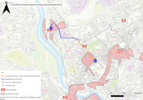
W3 - Exeter St David's to city centre via Queen Street

Plan of proposed W3 walking route (click on image to see full PDF plan) Delivering a more attractive and intuitive walking route between Exeter St David’s station and the city centre has been a long-term aspiration in the city. With redevelopment of the Exeter St David’s forecourt incorporated into the Liveable Exeter vision for ‘Red Cow Village’ there is an opportunity to progress this further. The route also passes the Hele Road and Queen Street campuses of Exeter College which means the area is frequently busy with people walking in the area.
Creating an improved and less car dominated arrival experience at Exeter St David’s station is a core part of this proposal, linking with the recently enhanced St Clements Lane. There may be scope to widen footways and provide priority crossings at side roads along St Davids’ Hill, Hele Road and Queen Street. A number of junction improvements are proposed to make it easier for people to cross along the route with the main focus on a major enhancement at the Clock Tower roundabout, investigating the scope to reallocate carriageway space and undertake a placemaking scheme in the area. Traffic circulation proposals could also be investigated relating to the removal of through traffic on Queen Street that would improve the environment for people walking and wheeling.
These proposals have synergies with cycling improvements proposed as part of routes E20 and E21.
If you would like to give feedback on this route, please fill out the W3 – Exeter St David’s to city centre via Queen Street feedback form.
-
W4 - Barnfield Road to Princesshay

Plan of proposed W4 walking route (click on image to see full PDF plan) Barnfield Road is an important gateway route into the city centre for residents funnelling in from St Leonards, Newtown and Heavitree. With enhancement schemes underway on Magdalen Road and proposals coming forward in Newtown, this route is likely to get busier with people walking and cycling.
A review of the signalised junction of Barnfield Road and Western Way to make this more intuitive to cross for people walking and cycling is an important focus on this scheme. There may also be scope to reallocate road space to widen footways from Western Way to Princesshay, incorporating side road priority crossings. A review of traffic circulation around Southernhay may also allow additional space to be reclaimed between Southernhay East and Southernhay West. This will all improve the walking, wheeling and cycling arrival experience into the city centre.
These proposals have synergies with cycling improvements proposed as part of routes E3 and E9.
If you would like to give feedback on this route, please fill out the W4 – Barnfield Road to Princesshay feedback form.
-
W5 - New North Road and Longbrook Street to Paris Street

Plan of proposed W5 walking route (click on image to see full PDF plan) This route will improve the connectivity between the busy residential areas of St James and Duryard with the city centre as well as improve linkages for people walking back and forth to the University of Exeter Streatham campus.
Recommended works will focus on investigating the possibility of changes to improve pedestrian priority at the junctions of New North Road with Longbrook, Blackall Road with Longbrook Street, and Pennsylvania Road with Union Road. Opportunities will be sought to widen footways and deliver junction narrowing, with side road priority, along the length of New North Road, Longbrook Street and Pennsylvania Road. This will make it easier for people to walk or wheel for their everyday journeys.
These proposals have synergies with cycling improvements proposed as part of the E4 route.
If you would like to give feedback on this route, please fill out the W5 – New North Road and Longbrook Street to Paris Street feedback form.
- Complete the online questionnaires. Paper copies are available upon request.
- Entire network questionnaire
- Route-specific feedback forms, which can be found in the individual route sections above.
- Attend one of our consultation events. These events will be held in the Ante Chamber, at County Hall off Topsham Road (which is fully wheelchair accessible). Travel options to County Hall can be found on the Devon County Council website. These public exhibitions will be a chance for you to see the plans and speak to members of the project team and will be open 11:00 am – 7:00 pm on:
- Tuesday 14 February
- Wednesday 15 February
- Wednesday 15 March
- Thursday 16 March
- Give feedback directly to a member of our project team by contacting us:
- in writing to Transport Planning, Room 120, County Hall, Topsham, Exeter, EX2 4QD
- by phone on 0345 155 1004
- by email to transportplanning@devon.gov.uk


Walking routes
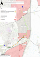
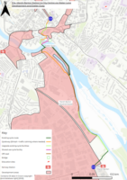
The walking routes within the Exeter LCWIP overlay existing walking provision in the city. Some parts of the existing network are included in the proposals and where necessary improvements have been recommended. The city was split into key walking zones, and the LCWIP has focussed on the city centre walking routes.
Of all city centre walking routes proposed in the LCWIP, 5 routes have been identified as priority routes. For these priority routes, high level suggestions of infrastructure have been identified. However, detailed design on individual routes has not yet been undertaken. As routes are progressed to detailed design, further consultation will be carried out.
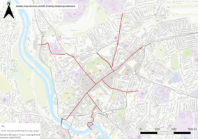
Details of the 5 priority routes can be seen below.
To give feedback on the overall LCWIP walking network, please fill out the network feedback form
Scheme prioritisation
The interventions set out in the LCWIP are ambitious and will require external funding and further feasibility design work in order to be progressed further. It is therefore important that interventions are prioritised.
Government guidance states that priority should be given to improvements that are most likely to have the greatest impact on increasing the number of people who choose to walk and cycle, and therefore the greatest return on investment. Other factors may also influence the prioritisation of improvements such as the deliverability of the proposed works or opportunities to link with other schemes.
Each route was scored against a range of quantitative and qualitative criteria, with the scores compiled to provide an overall ranking of the routes. For full details of this methodology, please see the full LCWIP draft document.
Schemes will be broadly divided into three delivery periods, in order to achieve the aim of 50% of work trips originating in Exeter to be made by foot or cycle by 2030.
Have your say
There are several ways to provide feedback on the LCWIP.