Consultation
Clyst Valley and New Communities Local Cycling and Walking Infrastructure Plan
From
26/02/2024
Until
10/04/2024
Update March 2025: The final LCWIP, as revised following consideration of consultation feedback, has been adopted by Devon County Council’s Cabinet.
Update February 2025: Responses to this consultation are summarised in the Consultation Report.
We are working to deliver improved active travel facilities, providing more direct, convenient, safe and attractive options for local journeys. We believe that improved walking and cycling infrastructure would have the following positive impacts for our county:
- Accommodating growth – a shift towards active travel would reduce congestion, particularly in areas where new housing developments put additional pressure on roads.
- Supporting health, wellbeing and access for all – improving active travel networks can make cycling and walking a common form of exercise for more people.
- Improving accessibility and social sustainability – better infrastructure can make it easier to access employment and education, key services and facilities. Dedicated cycling infrastructure can also help improve accessibility for disabled people.
- Responding to the climate crisis – shifting to sustainable transport options such as cycling and walking is one of the most important ways to tackle transport emissions.
- Economic benefits and creating better places – studies suggest that people cycling visit local shops more regularly. Public realm improvements have been shown to result in increased trade for local businesses.
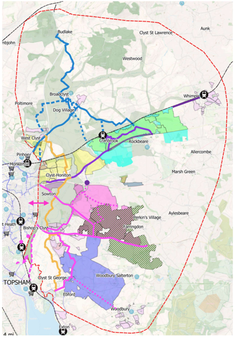
As part of our plans, from Monday 26 February until Wednesday 10 April, we are holding a consultation on our draft Clyst Valley & New Communities Local Cycling and Walking Infrastructure Plan (LCWIP). This identifies key potential routes in an area stretching from Killerton in the north to Topsham in the south, and from the Exeter boundary in the west to Whimple in the east. It has been developed by Devon County Council (DCC) in partnership with East Devon District Council (EDDC), and has been informed by previous engagement with key stakeholders.
Below is an overview of the proposed routes.
Please click on this link to read the LCWIP document in full. The consultation is open until Sunday 7 April at 11:59pm.
What is a Local Cycling and Walking Infrastructure Plan (LCWIP)?
Local authorities are required by the Government to produce LCWIPs, which analyse walking and cycling data to identify the cycling and walking infrastructure improvements needed in a particular area. This helps us to plan for future investment over the next 10-20 years.
The types of improvements put forward in an LCWIP might include new crossings, cycle routes that are physically separated from motorists and pedestrians, public realm improvements, traffic calming and wayfinding.
Have your say
Please let us know what you think by completing the survey linked below:
Clyst Valley & New Communities LCWIP Consultation Survey
Paper copies of the survey will be available at Clyst Vale Library, or can be requested by:
- emailing transportplanning@devon.gov.uk
- writing to:Transport Planning, Devon County Council, Room 120, County Hall, Topsham Road, Exeter, Devon, EX2 4QD
You can join us at our online event to hear more about the proposals:
Tuesday 5 March, 5pm-6pm
Please email transportplanning@devon.gov.uk to register for the online event.
We are also holding a drop-in event at the Younghayes Centre, 169 Younghayes Road, Cranbrook, EX5 7DR on Tuesday 26 March, 11am-2pm.
Following the close of the consultation, we will carefully analyse your feedback and will take it into account while preparing the final versions of the documents. We plan to publish the final versions of the LCWIP later in the year.
-
Context
Due to its location next to Exeter, the area surrounding the Clyst Valley in East Devon has seen considerable levels of development in recent years. This includes the sites of the Exeter and East Devon Enterprise Zone, and the first phases of the Cranbrook new community.
Further growth in the area is expected over the coming years, including the expansion of Cranbrook to around 8,000 homes and a population of 20,000 people, which would make it the second largest town in East Devon. A second new community is also proposed to the south of Cranbrook, which could also see an additional 8,000 homes. The creation of the Clyst Valley Regional Park will enhance the land surrounding the River Clyst and will encourage visitors to the area.
As with many rural areas and new communities on greenfield land, both East Devon and Cranbrook are relatively car dependent. Census data shows that just 2% of Cranbrook residents cycled to work in March 2021 – the same as the East Devon average. Just 3% of residents walked to work, which is significantly lower than the East Devon average, whereas levels of car commuting from Cranbook were significantly higher than the East Devon average. Many people are commuting into Exeter given the wealth of job and leisure opportunities the city provides. However, given many of these are doing so by car, they are contributing to Exeter’s significant congestion issues.
An increase in traffic from the new communities in East Devon would exacerbate this problem further. It is clear that with these existing levels of congestion on the local highway network, future growth in travel demand generated by housing development will need to be accommodated through alternative modes, with public transport, cycling and walking all playing a significant role.
-
Cycling
The LCWIP area currently has an inconsistent level of cycle infrastructure, with some excellent facilities, such as Redhayes Bridge on the E3/E4 route between Exeter and Cranbrook, and less attractive sections such as the E2 route between West Clyst and Broadclyst. However, the area faces significant challenges to increasing cycle use, including the current low levels of cycling, the rural nature of many routes and fragmented existing network.
By using geographic software to understand journey data, we have been able to locate and map the main trip origins and destinations and to understand the most direct routes between them (known as ‘desire lines’). Having determined the top priority desire lines, four sets of cycling routes have been developed, which are:
- Clyst Valley Trail
- Killerton & Broadclyst
- Cranbrook
- Local Plan 2020-2040 new settlement options
We believe that the recommended improvements to these routes would greatly improve cycling infrastructure in the area, with over 50km of additional traffic free and low-traffic cycle routes, suitable for all ages and abilities. Detailed information about each route is set out in the full LCWIP document.
-
Walking
Many existing roads within the settlements in the LCWIP area have footways for people walking. However, there is a still a need to continuously improve conditions for walking to encourage people to walk more often.
The LCWIP guidance recommends that core walking zones should be identified. These zones should normally be in areas with high levels of footfall – such as town centres or business parks – and be about a five-minute walking distance. However, the LCWIP area does not lend itself to a core walking zone, because it is still predominantly rural with small villages, and because larger settlements are still being built out (e.g. Cranbrook) or do not exist yet.
It is proposed that walking improvements in the LCWIP should be focused on:
- West Clyst to Broadclyst, which was identified by DCC, EDDC, and stakeholders as an important walking route. The two settlements are only one mile apart, and there are a significant number of school children that travel from Exeter via West Clyst to Clyst Vale Community College in Broadclyst.
- Incorporating walking improvements across all the proposed LCWIP cycling routes. For example, the Clyst Valley Trail will be a multi-use trail suitable for cycling, walking, wheeling, and horses.
-
Prioritisation and funding
The LCWIP sets out the proposed cycling and walking infrastructure improvements in order of priority and provides a high-level costing of the schemes.
Government guidance states that priority should be given to improvements that are most likely to have the greatest impact on increasing the number of people who choose to walk and cycle, and therefore the greatest return on investment. Other factors may also influence the prioritisation of improvements, such as the deliverability of the proposed works or opportunities to link with other schemes.
Given current levels of funding for cycling and walking, it is unlikely that all of the schemes within the LCWIP could be completed, even over a 20-year period. However, the LCWIP sets out a prioritised network that can be delivered as and when funding opportunities arise, for example from central government or housing/employment developers, enabling the eventual creation of a coherent, joined up network.
Accessibility
We take accessibility seriously and recognise that some of the information presented in the files available on this page may not be fully accessible to someone using assistive technology such as a screen reader.
If you need guidance or an alternative format, email transportplanning@devon.gov.uk with details of any preferred format and the assistive technology you use.