Introduction
The public consultation on the current design proposals for the multi-use Teign Estuary Trail between Newton Abbot and Teignmouth has now closed. The results of the public consultation can be found in the Public Consultation Report. For future updates on the scheme, please visit the existing scheme website.
Information and plans for the consultation can be viewed below. A consultation leaflet and a consultation poster are available to download.
Due to the current COVID-19 pandemic, no physical consultation events were held. However, the project team has held two virtual events online. The events were hosted on Microsoft Teams and could be joined online or by telephone.
On the 25 November, the project team held a short presentation covering the scheme proposals. This has been redacted to be GDPR compliant and the consultation webinar recording is now available. This was followed by a ‘question and answer’ session. On the 9 December, the virtual ‘drop-in’ event provided a further ‘question and answer’ session. In light of the sessions, the Frequently Asked Questions have been compiled below.
The consultation started on 17 November 2020 and closed on 18 December 2020.
Next steps
The project team is now reviewing responses with the aim of establishing an understanding of the support for the proposals and any issues raised. These will then be included in the ongoing scheme design where possible, with a view to submitting a planning application in Spring/Summer 2021.
Background of the Scheme
The Teign Estuary Trail is a key missing link in Devon’s active travel network and is an important scheme for investment. The Teign Estuary Trail seeks to complete the missing link in the strategic active travel network between Newton Abbot and Teignmouth. Connecting Dawlish, Teignmouth and Newton Abbot through the extension of the Teign and Exe Estuary Trails would form a national showcase, supporting leisure as well as local trips, and providing economic and health benefits.
The Teign Estuary Trail has been a long-term aspiration for Devon County Council and the current strategy seeks to deliver the route incrementally. Some sections have already been delivered, whilst design work has continued to progress on the outstanding sections. In March 2019, Devon County Council and Teignbridge District Council each committed funding to progress a planning application between the Passage House Inn on Hackney Lane in Newton Abbot and the junction near Morrisons Supermarket, located southeast of Bishopsteignton on the western fringe of Teignmouth.
Previous public engagement reflects the strong local desire for improved active travel opportunities along this corridor. The local authorities are continuing to engage with partners and the local community in order to progress the trail. The aspiration for the completion of the route is reflected in several local policy documents, including the Teignbridge Local Plan, Teignbridge Infrastructure Delivery Plan, Devon County Council’s Cycling and Multi Use Trail Network Strategy and Devon County Council’s Transport Infrastructure Plan.
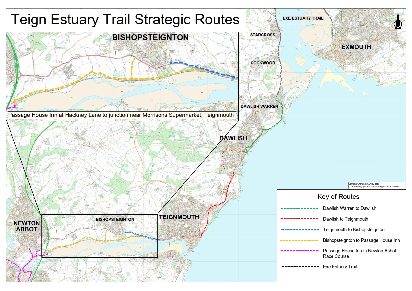
This map shows the different route sections of the Exe and Teign Estuary Trails. It also enlarges the section between Passage House Inn at Hackney Lane and the junction near Morrisons Supermarket in Teignmouth. The Strategic Routes map is also available for download.
Scheme objectives
The six scheme objectives are summarised below.
- To provide a strategic multi-use connection between Newton Abbot and Teignmouth, addressing the missing link of the National Cycle Network Route 2
- To promote recreation and leisure trips with increased access to the natural environment and supporting local tourism
- To promote sustainable travel as an alternative mode of transport, providing health and well-being benefits to local communities and supporting carbon net zero aspirations
- To optimise the amenity value of the Teign Estuary Trail and the enjoyment of the Teign Estuary
- To develop and maintain the Teign Estuary Trail in a manner which conserves and enhances the environment, whilst limiting adverse impacts
- To improve the safety of non-motorised users travelling between Newton Abbot and Teignmouth
Design process
Various alignments to connect Passage House Inn with Teignmouth have been considered, with the design undergoing multiple iterations to balance the various environmental and societal impacts. These have included maintaining a safe distance from the railway, minimising ground and construction works, and limiting the impacts on landowners’ land. A value management workshop was held with key stakeholders on 22 October 2020 in advance of the public consultation to discuss the proposed design.
South of the railway
The feasibility of delivering a route parallel to the estuary and south of the railway has been considered. However, these designs have not been progressed due to significant constraints being identified associated with construction within the estuary, including flood risk, the effects of climate change and sea level rise, related maintenance liabilities and the significant ecological impacts on the County Wildlife Sites and species living on the estuary.
Proposed scheme
The proposed multi-use trail will be built on land adjacent to the estuary and north of the railway between Passage House Inn and Bishopsteignton. The trail will then deviate from the railway line and join the A381 at La Roche Maurice Walk approximately 400m east of Church Road. From that point until the junction near Morrisons, Teignmouth, it is proposed to provide a shared path along the north side of the A381. The entirety of the multi-use trail will be at least 3m wide and 5 km long. There is more detail provided in the alignment plan in the middle.
The majority of the trail is largely located in open agricultural land with some short stretches crossing County Wildlife Sites (CWS) and Unconfirmed Wildlife Sites. The trail is designed to have a bound surface and follow contours as closely as possible, to reduce gradients .
New fencing and boundary treatments are proposed alongside the path to increase safety and privacy and reduce the likelihood of trespass onto adjacent land.
The proposed Teign Estuary Trail alignment plan is shown below and the table below summarises the different locations along the plan west to east starting from Hackney Lane in Newton Abbot to the junction near Morrisons in Teignmouth.
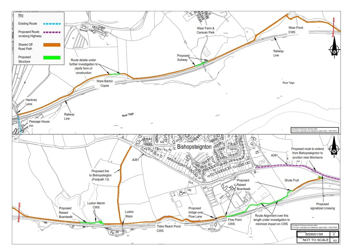
| Location | Description |
|---|---|
| Hackney Lane | Start of the multi-use trail. |
| Ware Barton Copse | Trail follows north of the mature tree line. |
| Wear Farm and Caravan Park | Proposed subway for the trail under existing track. |
| Wear Pond CWS | Trail follows north of mature tree line and south of a fresh water pond avoiding high value saltmarsh and mudflat habitat. |
| Luxton Marsh CWS | Proposal of zigzag boardwalk to overcome approximately 10 metre level difference. |
| Luxton Steps | The trail and Footpath 13 join. A gradual gradient, to ensure the routes inclusivity of all users. |
| Tides Reach Pond CWS | Trail follows north of the mature tree line. Some ash trees within the woodland area to be cleared for safety reasons. |
| Flow Lane | Trail to bridge over Flow Lane to discourage foreshore access. |
| Flow Point CWS | The alignment of the boardwalk in this location is subject to further adjustments to minimise impacts on high value saltmarsh habitats. |
| Shute Fruit | Trail follows north of the mature tree line. |
| A381 | The trail moves away from the railway line to cross the A381 and join the La Roche Maurice Walk. |
| Teignmouth | Shared path along the north side of the A381 to the junction near Morrisons at the western outskirts of Teignmouth. |
Impacts and mitigation
The design has been developed to achieve an optimal balance between maximising benefits and achieving the scheme objectives of developing and maintaining the Teign Estuary Trail in a manner which conserves and enhances the environment, promotes safe and sustainable travel and increases amenity value, whilst limiting any adverse impacts. Below are some of the key matters considered while developing the proposed design of the scheme.
Landowners
Several landowners will be directly affected where the trail will be constructed over their land. These landowners have been engaged throughout the scheme design with their local knowledge included. The alignment accommodates their concerns where possible and negotiations and engagement are ongoing.
Network Rail
At three locations, it is proposed to build the trail on Network Rail land in order to reduce the impact on productive agricultural land. Fences along the railway will be 1.8m high weld mesh but will vary based on the distance from the trail. Fences that retain good visibility are proposed to maintain outward visibility, minimise the impression of being enclosed and discourage anti-social behaviour.
Environment
The trail will be located on the largely undeveloped coast of the Teign Estuary. This tidal section of the Teign river is in a stunning landscape rich in wildlife and contains several sites of local ecological significance. Very careful consideration has been given to the design and the alignment of the trail in order to conserve and enhance the environment, whilst limiting any adverse impacts. The design seeks to minimise impacts on environmentally sensitive areas such as County Wildlife Sites along the proposed trail, which are designated for their high value habitat and contain lagoons, priority mudflat, reedbed and saltmarsh habitat. Where impacts are unavoidable, the precise alignment has been selected to avoid the most valuable ecological habitats and communities.
Several mature, veteran trees and group of trees were identified as important landscape features, these are locally significant for wildlife and are considered of high value. Wherever possible these have been avoided. No veteran or mature trees are proposed to be removed, except for some Ash trees for safety reasons due to the Ash Dieback disease. Any vegetation removed as a result of the construction of the trail will be replanted on site where habitat connectivity or habitat mitigation are required.
When it is not possible to compensate for the loss of habitat on site and in order to meet the required 10% biodiversity net gain, offsite planting and habitat creation will be provided in the local area. Suitable approaches to mitigation and compensatory provision will be demonstrated through the planning application stage in order to meet local and national planning policy requirements.
The general topography in the area is open agricultural land sloping down from north to south towards the Teign Estuary. Several watercourses drain water from the land into lagoon areas or pass via culverts under the railway into the Teign Estuary. At these locations the trail will either bridge over the watercourses or pass on boardwalk structures over lagoons and low-lying marshy areas. Care has been taken over the levels of the route to address concerns over global warming and flood zones. At locations on the edge of or adjacent to flood zones, escape routes for users will be identified to accommodate adverse weather conditions. Designs principles have been discussed with the Environment Agency.
Numerous undesignated historical features have been identified along the railway and proposed trail. Further local archaeological investigation may be required prior to construction to mitigate potential cultural heritage impacts.
Sustainability
Greenhouse gases will arise from the construction phase where the main contributors will be the production of new material and the movement of material and equipment to and from the site.
This can be mitigated by maximising the material re-used on the site, the use of new materials with high recycled content, good durability, and sourcing suppliers and waste facilities as close to the site as possible. In the operational phase, once the trail is open for use, there will be no greenhouse gas contribution to the environment as the trail will be used by pedestrians, cyclists and mobility scooter users.
This trail will provide the opportunity for people to safely travel actively between Newton Abbot, Bishopsteignton and Teignmouth. Currently such an opportunity does not exist, as there is no safe, convenient or direct non-motorised user access between these locations. It will also encourage people to use active travel whilst accessing the natural environment, which will improve mental and physical health.
Local Transport Network
The Teign Estuary Trail is vital to link to local sustainable travel opportunities as well as contribute to the strategic cycle connectivity along the National Cycle Network Route 2 and onward links towards Dartmoor via Newton Abbot.
The alternative sustainable travel options are approximately three trains an hour, the ‘2’ bus every half hour and the ‘184’ bus four times a day along the A381. The A381 is a busy road that carries approximately 15,000 vehicles per day between Bishopsteignton and Teignmouth, with up to 40 mph speed limit and narrow verges.
Footways are only available between Bishopsteignton and Teignmouth. This is not an attractive route for pedestrians, cyclists or mobility scooter users.
The proposed trail improves connectivity and complements the existing sustainable transport opportunities, with the potential for travel via public transport one way and utilising the Teign Estuary Trail the other way.
Contact
If you would like further information regarding the scheme, please get in touch using the contact details below:
- Email: transportplanning@devon.gov.uk
- Phone: 0345 155 1004
- Post: Transport Planning, Matford Offices, County Hall, Topsham Road, Exeter, EX2 4QD
Accessibility
We take accessibility seriously and recognise that some of the information presented in the files available on this page may not be fully accessible to someone using assistive technology such as a screen reader. If you need guidance or an alternative format, email transportplanning@devon.gov.uk with details of any preferred format and the assistive technology you use.
Further documents
- More Detailed Design Plans
- Existing Scheme Website
- Press Release
- Value Management Workshop Briefing Note
- Value Management Workshop Minutes
- Consultation Webinar Recording (25 November 2020)
- Public Consultation Report
Frequently Asked Questions
Question: What are the next steps for the Teign Estuary Trail and when will it be completed?
Answer: Following the close of the public consultation, the responses received will be reviewed. The design will be amended, where necessary, and a planning application will be submitted in 2021. Once planning permission is secured, suitable funding opportunities will be sought. Without planning permission, the route does not have a strong case for securing external funding from competitive bids. Timescales for delivery will be subject to securing suitable levels of funding.
Question: Will the Teign Estuary Trail be suitable for users of mobility scooters or wheelchairs?
Answer: The Teign Estuary Trail has been designed so that it is suitable for use by mobility scooters and wheelchairs as well as pedestrians and cyclists.
Question: Why does the trail stop at the edge of Teignmouth?
Answer: The Teign Estuary Trail is intended to be delivered incrementally. The current proposals cover the section between Passage House Inn and Morrisons Junction, Teignmouth. Once the trail enters the urban area east of Morrisons junction, there are a range of constraints that make the identification of a suitable route more complex. These include: side road accesses, frontage development and on-street parking. In order to progress the current proposals, the urban environment through Teignmouth has been excluded and will form a long-term future section for consideration.
Question: Can the trail be located on the estuary side of the rail line?
Answer: The flood risk assessment requires the route to be located outside of the estuary flood zones (primarily north of the railway) where possible. On the estuary side, most of the trail would have to be on structure where the construction and maintenance costs would be prohibitive.
Question: What measures will be used to address wildlife impacts during the scheme construction?
Answer: The scheme has been subject to a range of environmental studies, including an ecological assessment, in line with planning requirements. A series of mitigation measures will be applied to limit and offset any unavoidable impacts both during the construction and operation of the scheme. Examples of approaches used during the construction of the Exe Estuary Trail included controls over the timing of construction work and the use of screening the avoid disturbance to critical wildlife interests. The precise nature of mitigation measures to be applied to the Teign Estuary Trail will vary at different points along the route; more detailed information on specific locations could be provided upon request.
Question: What type of fencing will be used along the Trail?
Answer: Boundary treatments are proposed alongside the path to increase safety and privacy and reduce the likelihood of trespass onto adjacent land, as follows:
- where adjacent to the railway line, a 1.8m high weldmesh fence is proposed
- where adjacent to agricultural land, various heights of Devon hedgebanks and types of stockproof fencing are proposed
- Along every boardwalk section protective handrails are proposed on both sides.
Alternative boundary treatments will be considered in consultation with adjacent landowners to ensure bespoke arrangements are included where necessary and appropriate.
Question: Can a bridge be considered to cross the A381 rather than a signalised crossing?
Answer: A bridge would have to be built at a sufficient height to clear the highway and allow all motorised vehicles under it. This would create a steep gradient on the trail which would not be practical for all users. A number of ramps and additional land take would be required. A bridge is therefore not considered to be feasible in this location.
Question: The current visibility for driveways exiting onto the A381 is limited and the delivery of the Teign Estuary Trail is expected to increase users of the current footway. How will the proposals along the A381 ensure safety for all users, including those utilising the driveways?
Answer: It is proposed that the current footway is converted to shared use with a minimum width of 3m. The kerb will be moved in the southern direction, with the road carriageway narrowed. In addition, the speed limit is proposed to be lowered on the A381. Measures will be included within the design to maximise the available visibility for vehicles exiting the driveways, whilst slowing cyclists and diverting them from the blind aspects of the driveways.
Question: Will there be access from Flow Lane to the trail?
Answer: Currently there is no provision for a connection between Flow Lane and the trail. This is to discourage people from joining the trail at the sharp bend where Flow Lane joins the A381 with limited visibility and poor crossing facilities. This will also discourage trail users from accessing the foreshore that is a Country Wildlife Site and is privately owned land.
Last updated on 15 March 2021.