The results of this consultation have been summarised in this consultation report.
Frequently asked questions have been gathered, which can be seen here along with the answers.
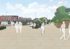
Devon County Council is proposing to make a number of active travel and public realm improvements to the area around Exmouth railway station. By encouraging more active travel, particularly for shorter journeys, we can help reduce congestion on our busy roads and improve connectivity across the town. Along with improvements to the public spaces around the station, the proposals are designed to make the area a safer, more welcoming, and more pleasant place for all.
You Said, We Did
Earlier this year we asked for your feedback on our early ideas for the area. We met with stakeholders, held a public drop-in event and received over 850 responses to our online survey. A summary report on the earlier engagement is available here: Public Engagement Report.
This feedback has been carefully analysed and has been used to update the proposals, with the following changes being made:
- It is now proposed that a shared path would be introduced for use by both cyclists and pedestrians, rather than a segregated path that keeps cyclists and pedestrians separate. This has been deemed the best solution for safety and ease of use in the space available.
- The crossing outside the railway station is now proposed to be upgraded from a zebra crossing to a signalised toucan crossing. This would allow cyclists to use the crossing without dismounting and would likely improve traffic flow at busy times of day by stopping the constant stream of pedestrians across the road.
- It is now proposed that the flower bed and part of the wall near Marks & Spencer and the leisure centre would be retained.
Further consultation has now been held to get your feedback on the updated designs and on key features of the proposals.
Have Your Say
This consultation period is now closed. We asked you to provide your feedback via our online survey. The comments we received will help to inform future stages of the design process. The results of this consultation can be viewed in this consultation report.
We also hosted two public drop-in events, where you could find out more about the proposals and speak to members of the project team:
- Wednesday 6 December, 11:30am – 2:30pm at LED Exmouth Leisure Centre, EX8 1EN
- Thursday 7 December, 4:30pm – 7:30pm at Brixington Community Church, EX8 4JJ
Please bear in mind that the funding we have received from central Government is specifically designed to help improve the area around Exmouth railway station, including making it easier to navigate on foot or by bike. This funding was provided on the basis of the scheme submitted as part of the funding bid and cannot deviate away too much from this approved plan. The plans were also approved by Devon County Council, East Devon District Council and Exmouth Town Council prior to submission.
The Round 2 Levelling Up Fund bids were submitted via an online form and as such, this form is now unavailable. We can provide an internal working document that specifies our responses to the individual questions on the online form here.
Background and Project Aims
These proposals form part of the Destination Exmouth project, which is funded by the Government’s Levelling Up Fund, Devon County Council, East Devon District Council and Exmouth Town Council. The project aims to create a transport interchange that enables people to travel across town by bicycle, on foot or by bus more easily and creating an improved experience for people arriving in the town. The bid also includes the extension of Dinan Way to join up with the A376 to remove traffic from unsuitable residential and country lanes. The two schemes complement each other and could provide a number of benefits:
- Improved connectivity: Easier for people to get around town using all forms of transport.
- A warm welcome: Making the area a more welcoming and pleasant space for visitors.
- Helping local businesses: More people walking and cycling in the area, which supports the local economy and makes the area more attractive to live and work in.
- Safer streets: Safer for people who walk, cycle and use public transport.
- Faster journey times and less congestion: People spend less time traveling because of a shift towards use of public transport and active travel modes.
The Proposals
Please click on the map below to view the full proposals. Below is a written description of the improvements.
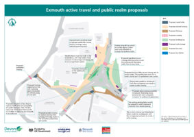
Area outside the railway station
Improved signage would be introduced outside Exmouth railway station, so that travelling from the station to the town, estuary and seafront is easier for visitors. Planters would be introduced near the entrances to Marks & Spencer and the leisure centre, with the flower bed and part of the wall to remain.
The existing drop-off bay just outside the railway station would be relocated slightly further south to increase footway width, improving accessibility for pedestrians and cyclists, especially those with mobility issues.
The path from the railway station down to the Manchester Road junction, and on the other side of Marine Way, down to The Strand Inn, would be a shared use path for use by both cyclists and pedestrians. This would make it safer and easier for pedestrians and cyclists to travel in this area and between town, the Exe Estuary and The Strand.
Subway
The existing subway near the railway station would be closed. Although closing the subway was opposed by almost 60% of respondents to the public engagement period, we are proposing to close the subway for a number of reasons:
- Scheme delivery: Removal of the subway access ramps would create space to widen existing paths near the railway station. Without this, it would not be possible to provide many of the proposed improvements because of limited space.
- Usage: A count carried out in September 2023 to compare the number of people using the subway to the zebra crossing showed that 82% (2520 of a total of 3079) of pedestrians and cyclists used the zebra crossing. This is consistent with past survey results.
- Safer and more convenient: Installing a signalised crossing on Marine Way would make it safer and more convenient for people walking and cycling between the station and town centre, particularly anyone with a disability. Pedestrian subways are widely associated with anti-social behaviour. This perceived danger can prevent pedestrians from using the subway, particularly vulnerable users at night.
- Cost: the subway periodically floods, requiring costly maintenance work. It is estimated that the cost of closing and infilling the subway with a suitable material will be approximately £220,000, so a cost saving for Devon County Council will be achieved in the long term.
Please see the ‘Supplementary Technical Information’ document for more information on the subway.
Imperial Road roundabout
The existing roundabout by the leisure centre would be modified, with lane widths made narrower to discourage overtaking and to encourage lower speeds.
On the north arm of the roundabout, near the railway station and Marks & Spencer Foodhall:
- a signalised toucan crossing would replace the existing zebra crossing. This would:
- create a wider crossing area, allowing cyclists to use the crossing without dismounting;
- encourage people to cross the road in groups, rather than as a steady stream of individuals, which can hold up traffic for long periods at busy times of day. We will be conducting traffic modelling to better understand the impact that the upgraded crossing will have on traffic flow;
- provide a more direct route for pedestrians and cyclists to cross the road by moving the crossing slightly closer to the roundabout. Moving the crossing will also reduce the likelihood of drivers confusing the crossing signal with one controlling flow into the roundabout.
On the south western arm of the roundabout:
- a parallel (combined pedestrian and cycle) crossing would replace the current zebra crossing near Manchester Road, improving access to The Strand for pedestrians and cyclists;
- the current uncontrolled crossing near Manchester Street would be reconfigured, with the carriageway narrowed to create a safer crossing;
- a raised table would be introduced at the Manchester Street junction with Imperial Road, slowing traffic and increasing safety for cyclists and pedestrians;
- the bus stop outside the leisure centre would be relocated 20m to the south to improve traffic flow and accessibility for public transport users. The bus layby and central reservation would be modified to allow for the footpath to be widened.
On the east arm of the roundabout:
- a new zebra crossing would be introduced outside The Strand Inn, improving access between the town and public transport for cyclists and pedestrians;
- a raised table would be introduced across the access road to the pub, with the carriageway narrowed to create a safer crossing;
- the existing cycle parking in this area will be updated to suit the proposed shared space;
- the existing on-street parking opposite The Strand would be moved slightly east to create a wider footpath;
- the existing parking layby would be reduced in width to prevent motorists from double parking. Taxi parking would also be removed.
Leisure centre car park
The access road (part of The Royal Avenue) to the small car park outside the leisure centre would be reconfigured:
- a raised table would be introduced at the top of the road to encourage lower vehicle speeds and improve safety for pedestrians and cyclists;
- the footpath along this stretch of road would be widened, with a passing space introduced for vehicles using the car park;
- cyclists traveling to the estuary to be directed from the shared path outside the leisure centre onto the access road carriageway;
- a pedestrian crossing would be introduced on The Royal Avenue (near the entrance to the access road), making it easier for people to cross.
15/12/23 update:
Following a query about the proposal to narrow road widths on the arms of Imperial Road roundabout, we have updated the technical drawing to clarify what the proposed new road widths would measure, and to make it easier to compare the proposals to the current road layout. You can access the updated drawing (titled: ‘Technical drawing of the site – updated with road measurements‘) in the Supporting Documents section below. If you have already responded to the consultation survey and would like to update your response, please email us at transportplanning@devon.gov.uk
Accessibility
We take accessibility seriously and recognise that some of the information presented in the files available on this page may not be fully accessible to someone using assistive technology such as a screen reader.
If you need guidance or an alternative format, email transportplanning@devon.gov.uk with details of any preferred format and the assistive technology you use.
Supporting Documents
- Supplementary Technical Information
- Overview Map
- Technical Drawing of the site
- Destination Exmouth Draft Round 2 LUF bid
- Technical drawing of site – updated with road measurements.
Public Engagement Documents
Earlier this year we asked for your feedback on our early ideas for the area. The below documents are the ones used at the time of the previous engagement and have now been superseded.
Email: transportplanning@devon.gov.uk
Phone: 0345 155 1004