Last updated: 12 January 2024.
Updates
10 January 2024 – The Final BBN LCWIP Report has been approved by Cabinet. Decision detailed as Item 457 at the Cabinet meeting.
February 2023 – The Final BBN LCWIP Report that has been endorsed by Torridge and North Devon Highway and Traffic Orders Committees is now available.
Changes made to the draft document to finalise were as follows:
- Updated date references.
- Forewords added in from MP and Councillor.
- Added in section on who contributed to funding on page 4 of 80.
- Figure 3-13 Yelland to Barnstaple Longbridge section B proposal: Relevant text in Section B amended as proposed changes to Shieling Road have been removed.
- Figure 3-17 Pilton to Roundswell section C proposals: Number 6 added in.
- Figure 3-25 West Bideford to East-the-Water section A proposal: Relevant text is Section A (number 6 and 8) amended as a section of the proposed changes on Clovelly Road were labelled incorrectly.
- Corrected general spelling / grammar mistakes.
October and November 2022 – The Draft BBN LCWIP report with adjustments has been taken to Torridge and North Devon HATOC and has been approved by both. Please find the report attached within the Torridge Committee minutes of their meeting held on the 31st of October 2022 or within the North Devon Committee minutes of their meeting held on the 16th of November 2022, on their respective websites.
October 2022 – The Public Consultation Report is now available. The report summarises the statistics from the questionnaire, the comments respondents have provided and Devon County Council’s responses to these and amendments proposed.
12 October 2022 – The public consultation has closed.
Introduction
The public consultation was held from the 21st September to 12th of October 2022 on the Draft Barnstaple with Bideford and Northam Local Cycling and Walking Infrastructure Plan (BBN LCWIP). The aim of the consultation was to find out if the public feels that the LCWIP is reflecting the needs and wants of the community and local area.
Following the consultation, the responses were reviewed and necessary amendments were made to the LCWIP document before it was finalised.
The summary of the draft BBN LCWIP Report that was taken to the consultation is provided below.
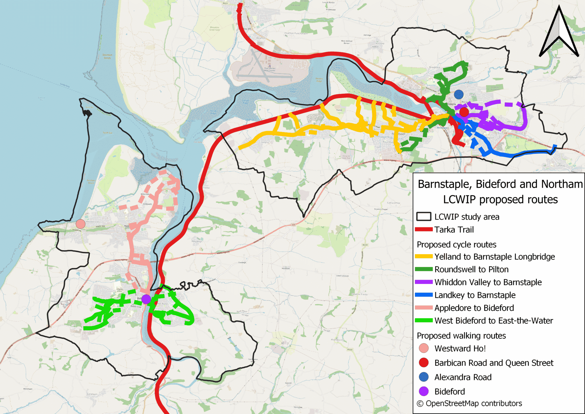
The map below shows the 10 walking and cycling schemes proposed in the study area.
LCWIP background
Please watch this 3-minute video on The Introduction to LCWIP. This video was produced for the stakeholder engagement that was held in April 2022, and stakeholder comments were taken into account when developing the proposals further, which are included in the plans provided for this consultation.
The draft BBN LCWIP is an evidence-based approach to identifying the gaps in the existing active travel network. It seeks to outline the focus of future walking and cycling investment over the next 10-20 years. It follows the Department for Transport’s LCWIP framework which forms a vital part of the government’s strategy to increase the number of trips made on foot or by cycle.
Please watch this 8-minute video on the Process of Network Planning for Walking and Cycling in Barnstaple. Another video with the same audio is available showing maps of the Bideford and Northam area: Process of Network Planning for Walking and Cycling in Bideford and Northam. These describe the analysis that went into identifying the gaps in the existing network.
LCWIPs are becoming more instrumental in obtaining government funding, encouraging transformative development in the local area.
LCWIPs are intended to:
- plan for cycling and walking using evidence and data on existing and future potential demand
- target investment where it can have the greatest impact
- identify cycling and walking infrastructure improvements in readiness for funding bids
- plan cycling and walking networks that meet core design outcomes and the needs of users
A wide range of factors were considered in order to identify the proposed improvements in the draft LCWIP. These included:
- existing travel patterns
- road safety statistics
- links to planned growth sites
- suggestions from key stakeholders
- an assessment of where interventions are already planned
- connectivity into strategic links, such as public transport and education sites
The BBN LCWIP seeks to identify new schemes and infrastructure which are not already included in existing plans. Cycle and walking infrastructure schemes have been outlined in the Devon County Council Transport Infrastructure Plan (2020) and are currently at various stages between being designed, being granted planning permission or being approved and funded for implementation. Therefore the schemes proposed below are not part of the LCWIP.
- Larkbear pedestrian and cycle bridge across the A361.
- Clovelly Road Caddsdown Link.
- Bideford to Northam cycle under the A39.
- Kenwith Valley cycle link along the old Bideford to Appledore rail line.
- Footway between Bideford and Abbotsham Village.
- Landkey junction pedestrian and cycle bridge across the A361.
- Bishops Tawton Roundabout crossing of the A361.
- Strategic Green Infrastructure links, from Pottington, Sticklepath and Bickington to the Tarka Trail.
The proposals contained within the LCWIP seek to help the area in the following ways:
Responding to the climate crisis
Devon County Council, North Devon Council and Torridge Council have declared a climate emergency and have signed the Devon Climate Declaration. The Devon Carbon Plan identifies that reducing the need to travel and shifting to sustainable transport options such as cycling and walking are the most important ways to tackle transport emissions.
Supporting health, wellbeing and access for all
Active travel can play a crucial role in supporting public health and wellbeing.
Focussing on inclusive ‘All Ages and Abilities (AAA)’ design and ensuring cycling is accessible for everyone are core design considerations when developing and delivering schemes through the LCWIP process.
The network must be coherent, linking key origins and destinations. Direct and fast routes, that follow desire lines and avoid unnecessary detours.
The route and the environment must feel safe. Routes must be comfortable, with minimal stopping and starting, and avoid steep gradients. All routes must be attractive to create pleasurable routes and experiences.
Improving accessibility and social sustainability
It is important that all residents can access employment, education opportunities, key services and facilities. Delivering improved active travel connections between key destinations will be important in this regard.
Enabling people to cycle and walk increases the level of social interaction on streets and in neighbourhoods. This has been shown to have a positive impact on issues such as loneliness and builds improved levels of trust in communities.
Accommodating growth
There is significant levels of planned housing and employment development in the area, and this growth will add additional pressure to the area’s transport network. Therefore, there is a need for a substantial shift to cycling and walking, combined with wider improvements to other transport infrastructure.
Economic benefits
A review of national and international studies showing the economic value of investing in cycling infrastructure found that cycle schemes can achieve more for less, people cycling visit local shops more regularly, spending more than users of most other modes of transport; neighbourhoods with cycle-friendly characteristics – low traffic volumes, walkable, close to off-road cycle paths – are more desirable or have higher property values; and, cycle tourists on average spend 9% per head per trip more.
The areas that the LCWIP focuses on in its proposals were determined through rigorous evidence-based review of existing cycle trip demands and issues, already planned cycle infrastructure and future development growth. This process identified key movement corridors for further investigation which were then developed into routes using Department for Transport guidance.
Progress on the delivery of the LCWIP proposals will be subject to the identification and securement of suitable funding sources. Devon County Council, Torridge District Council, North Devon District Council, Barnstaple Bideford and Northam Town Council have already contributed to develop the LCWIP report.
External funding sources are most often realised through central government funding pots with specific eligibility criteria or through developer contributions, which are contingent on the delivery of associated development.
This means that any delivery of the proposals in the LCWIP will in most cases be reliant on funding that would otherwise not be within the councils’ control to use for other purposes.
Walking proposals
Below are the four walking corridors within the LCWIP, with selected interventions highlighted for each. All these interventions are potential responses to gaps identified in the existing active travel network; they are aspirations and are not guaranteed to be progressed onto further stages of design.
-
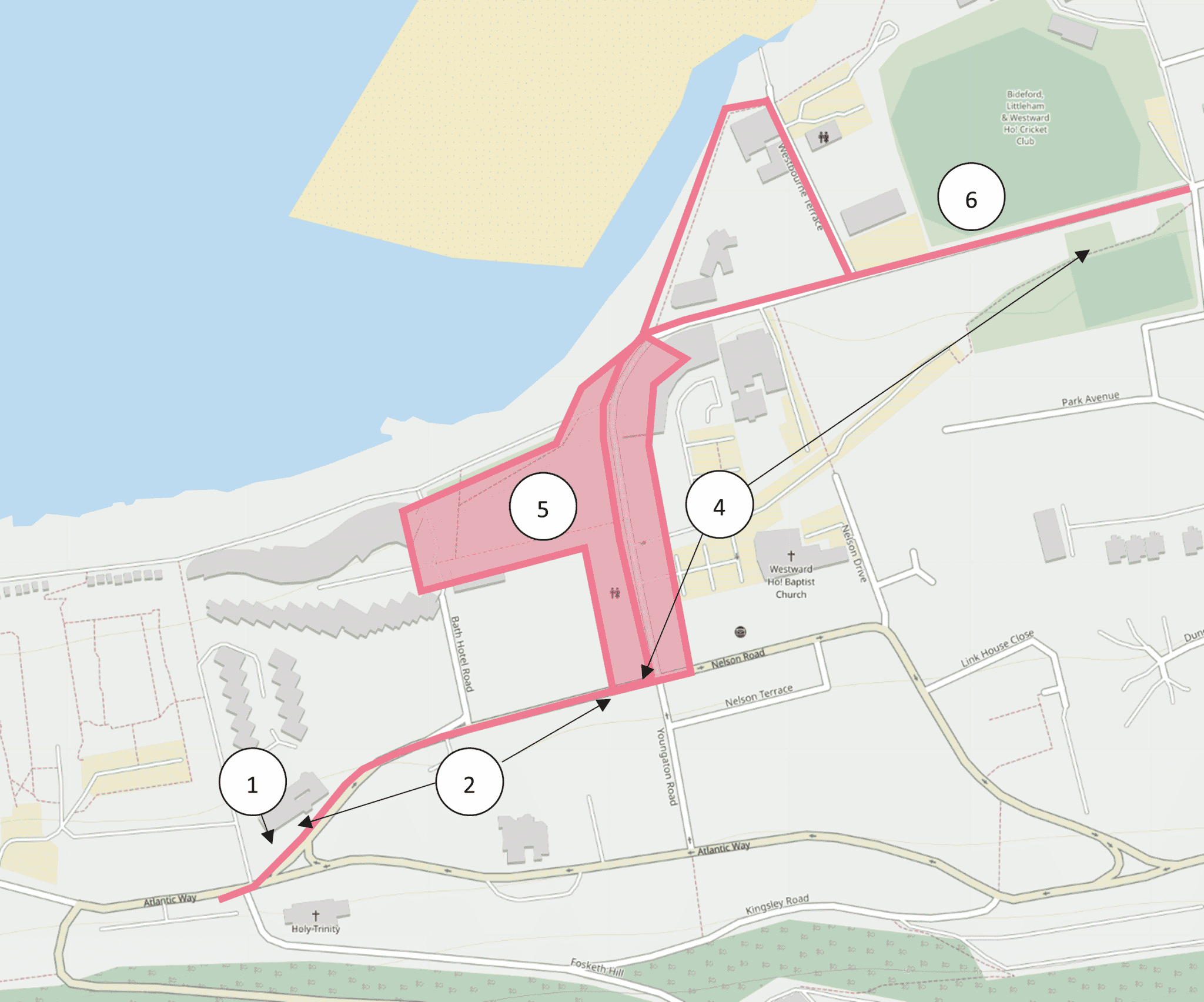
Westward Ho! walking zone

- New formal pedestrian crossing
- Wider footpath
- (Not shown on map) Area wide review of kerbs
- One way traffic to widen pedestrian area
- New surface with traffic calming
- Wider footpath
For full details on the proposals, please refer to page 58 of 68 in the Draft BBN LCWIP Report.
-
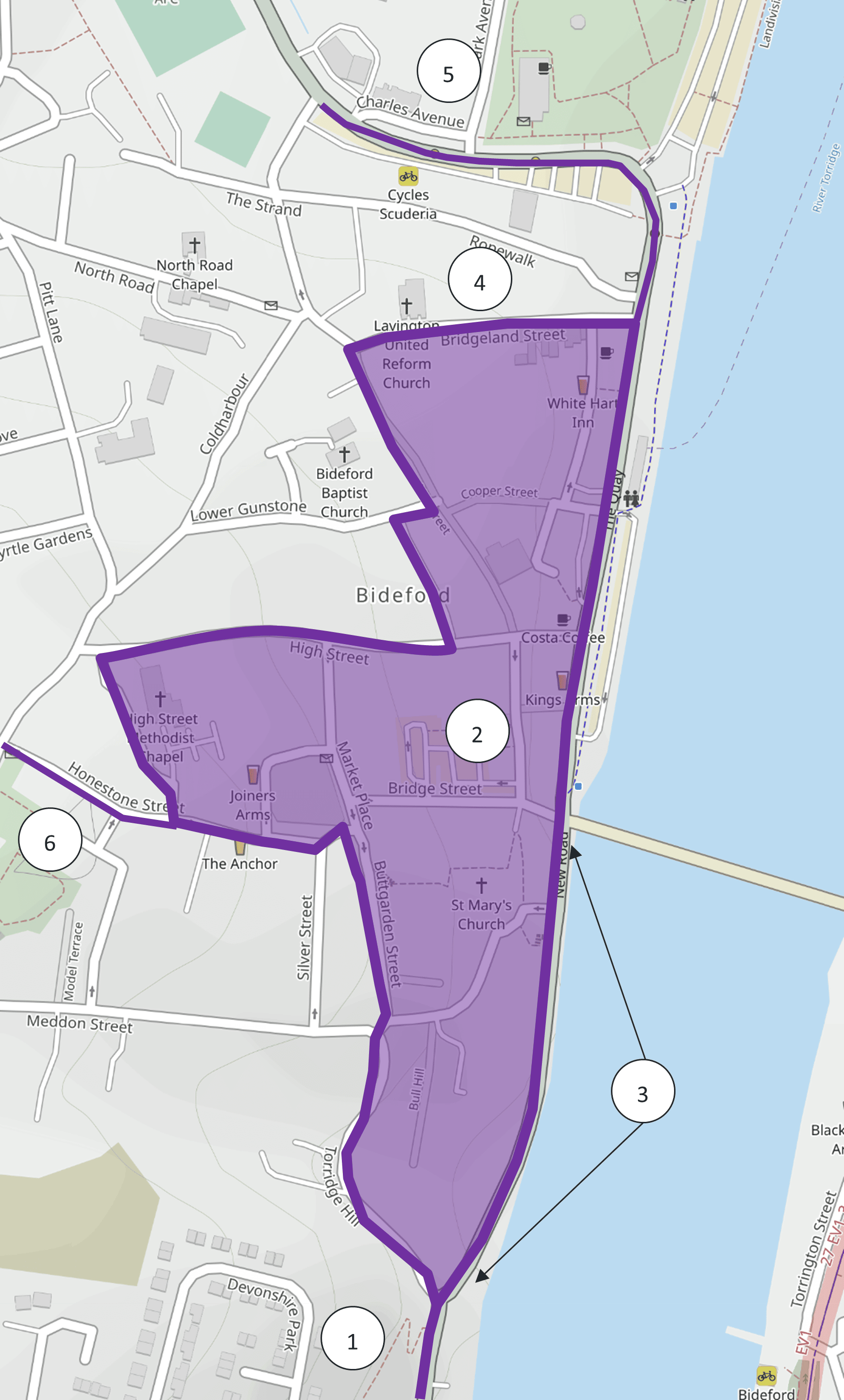
Bideford walking zone

- Wider footpath
- Wider footpath
- Improve crossing
- One way traffic to widen footpath
- Improve existing zebra crossing
- Improve crossing
For full details on the proposals, please refer to page 61 of 68 in the Draft BBN LCWIP Report.
-
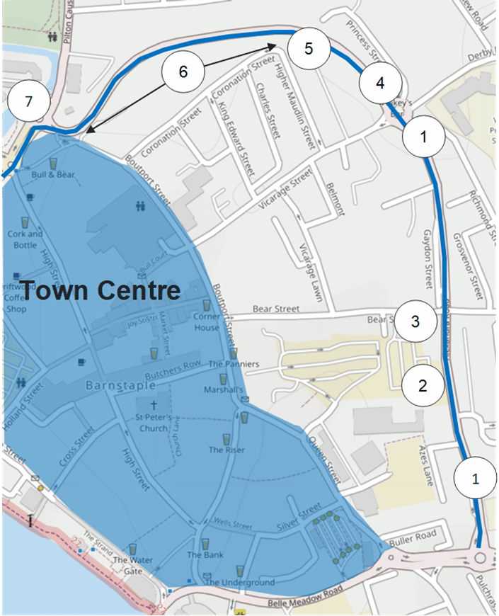
Barnstaple - Alexandra Street walking zone

- Realignment of existing crossing
- Wider pavement
- Improve existing crossing
- Improve existing crossing
- New zebra crossing
- Wider footpath
- Review junction, improve experience at gateway
For full details on the proposals, please refer to page 60 of 68 in the Draft BBN LCWIP Report.
-
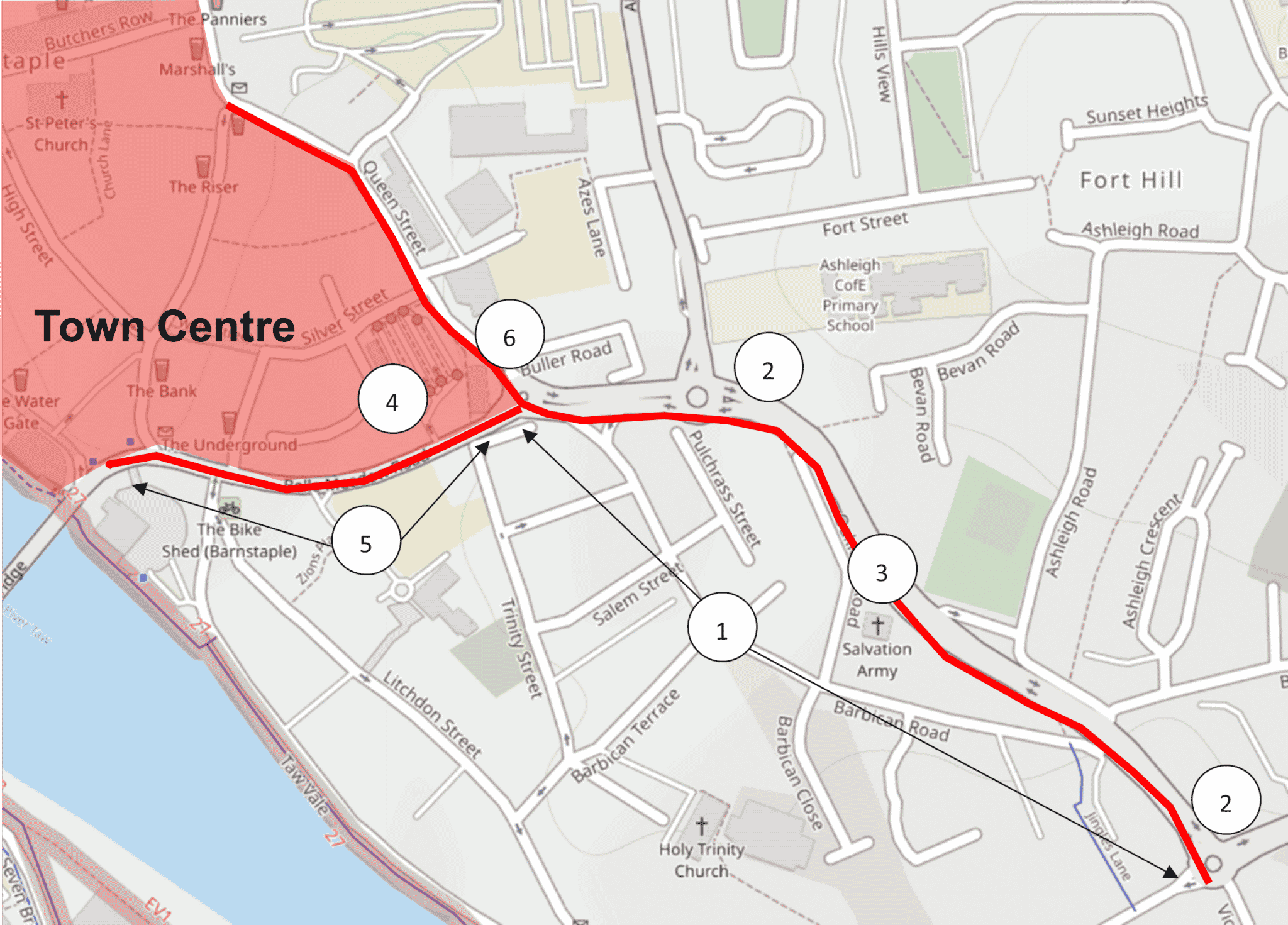
Barnstaple - Barbican Road and Queen Street walking zone

- Road space realignment – wider footpath, better crossing
- Two new controlled crossings
- Realign existing crossing
- Relocate existing crossing to Bus Station
- Wider pavements
- Reprofile junction
For full details on the proposals, please refer to page 59 of 68 in the Draft BBN LCWIP Report.
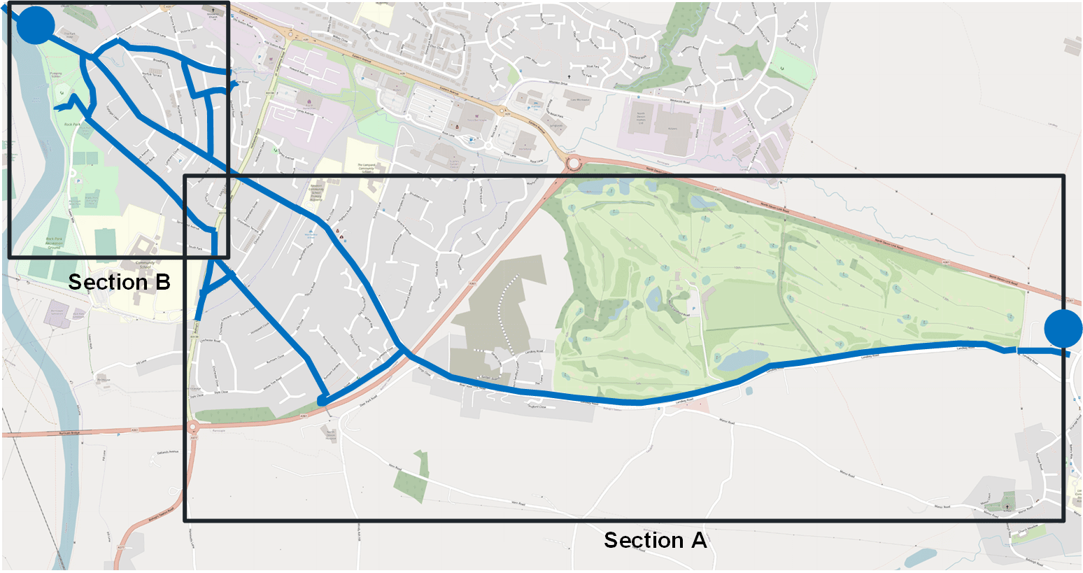
-
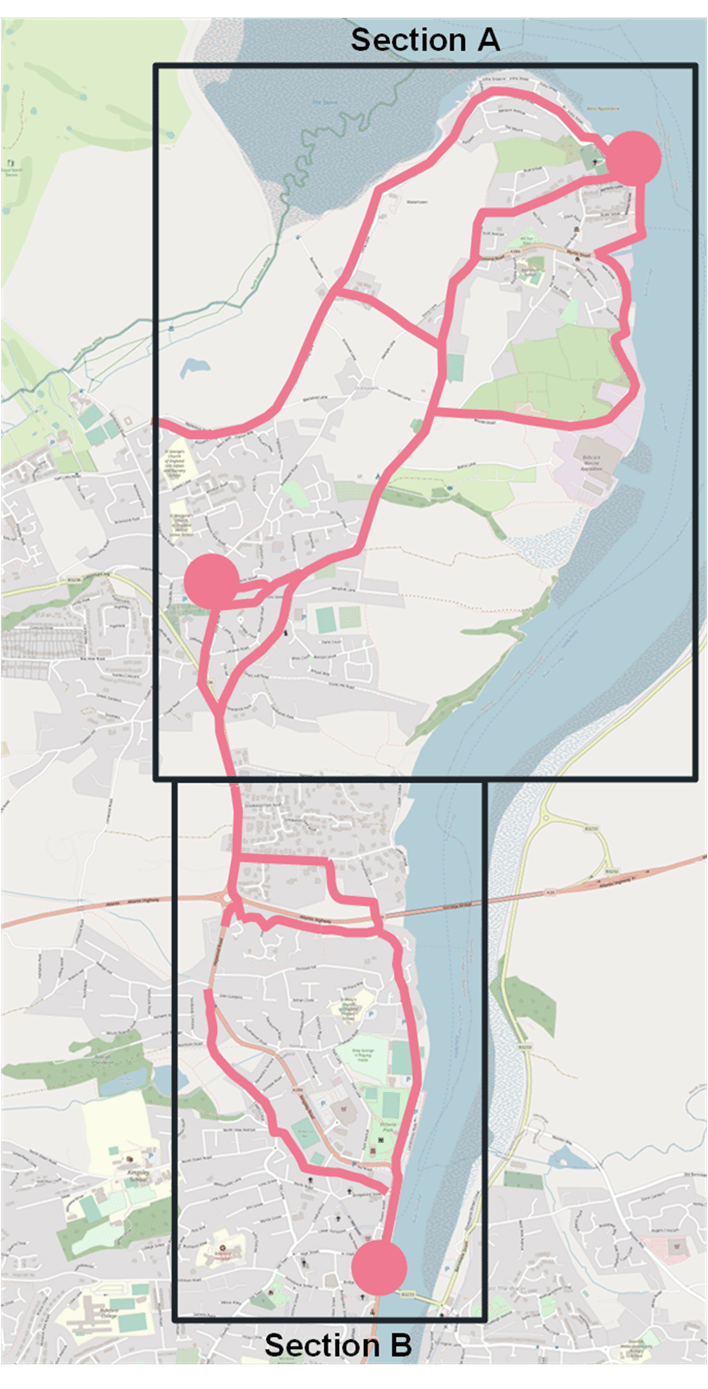
Appledore to Bideford

For full details on the proposals, please refer to page 46 of 68 in the Draft BBN LCWIP Report.
Section A

- Create more space in public realm
- a/b/c Create a network of quiet routes
- New shared use path
- Widen shared use path
- Continue shared use path
- Widen cycle path
- New shared use path, improve public realm
- Signpost to quieter routes, install new crossing
Section B

- Review width of existing shared use path
- New traffic-free passage, clear signposting
- Improve crossings
- Signpost to low-traffic route
- New cycle route
- Review route through park
- Raised crossing
- Review existing shared use path
- Signpost to quiet on road route
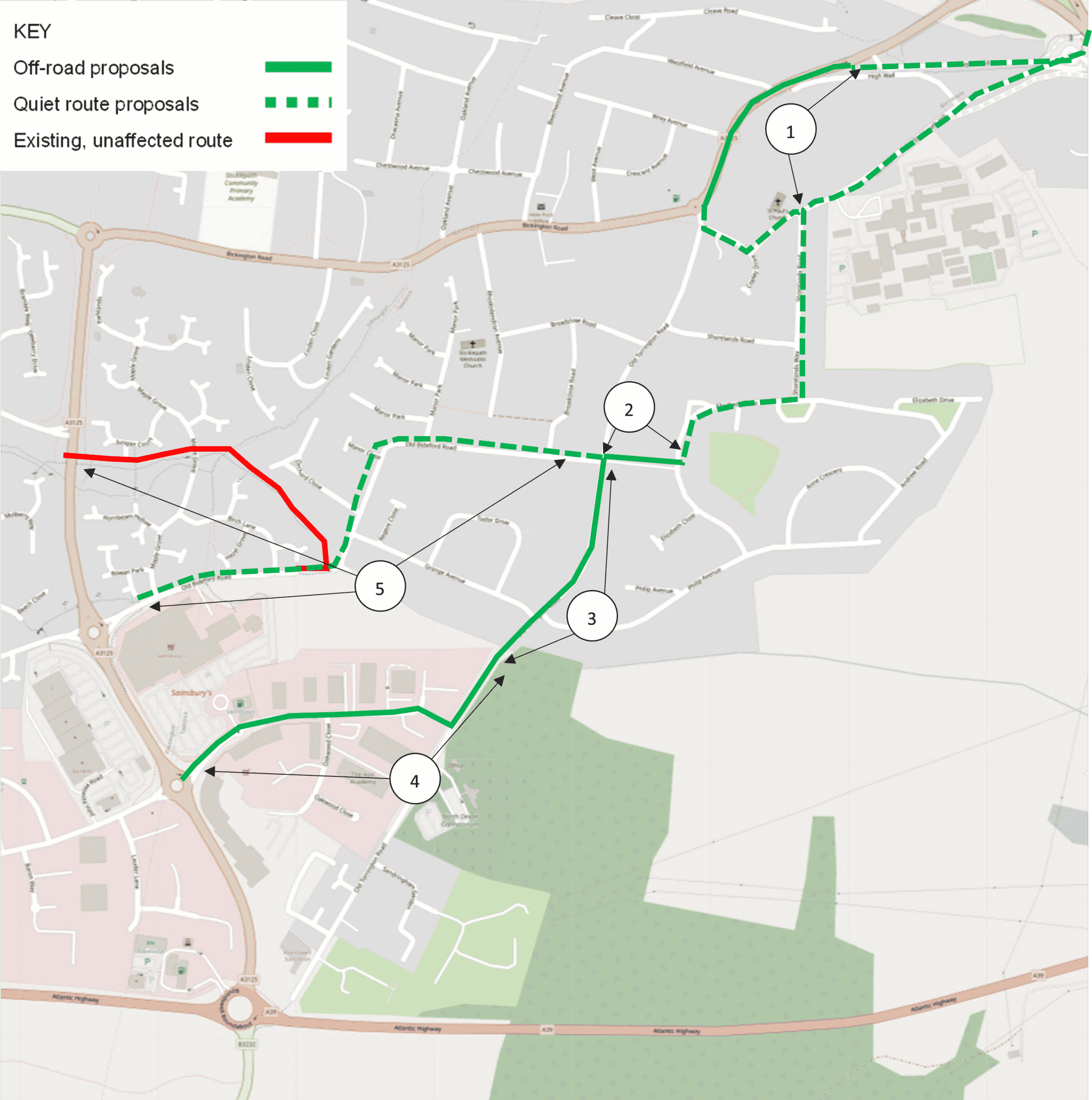
-
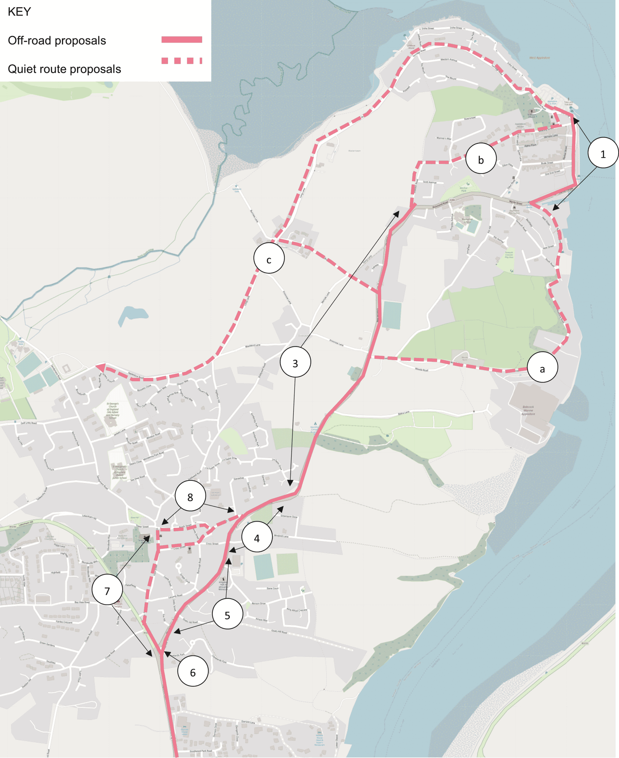
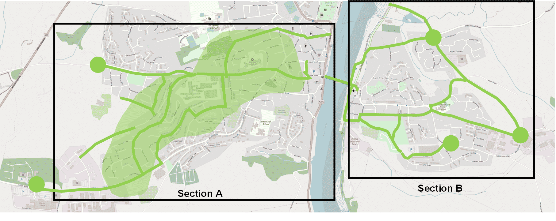
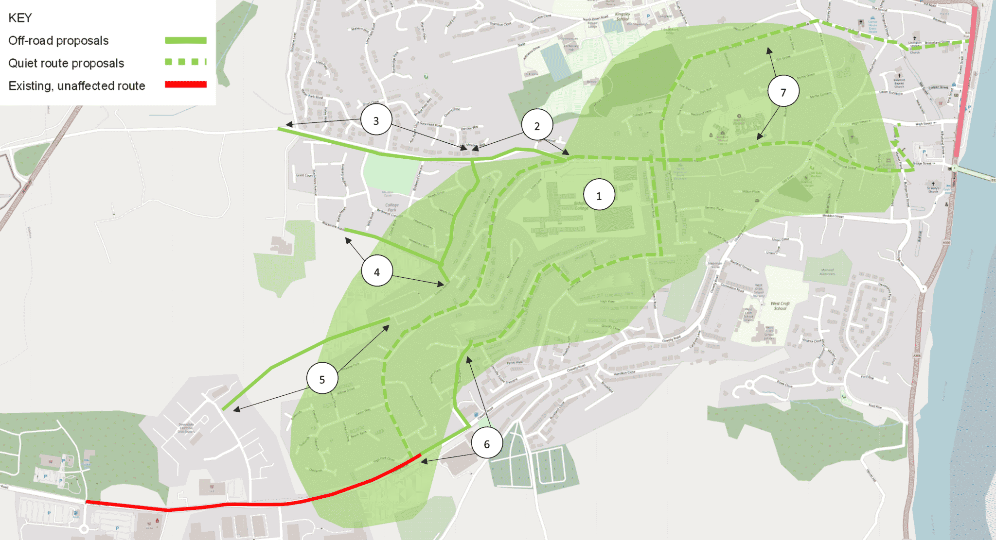
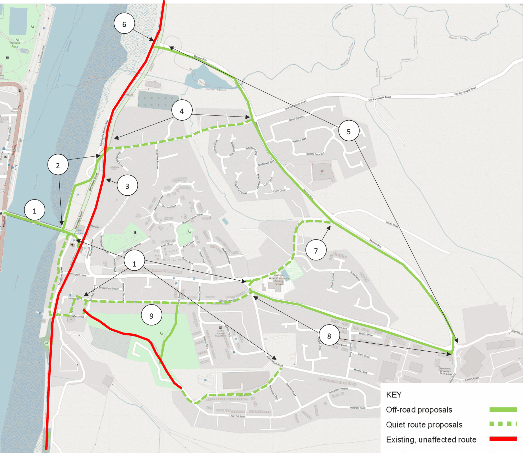
West Bideford to East-the-Water

For full details on the proposals, please refer to page 50 of 68 in the Draft BBN LCWIP Report.
Section A

- Create network of quieter streets
- New shared use path
- Review existing shared use path
- New shared use path
- Surface route
- New shared use path
- New signposts
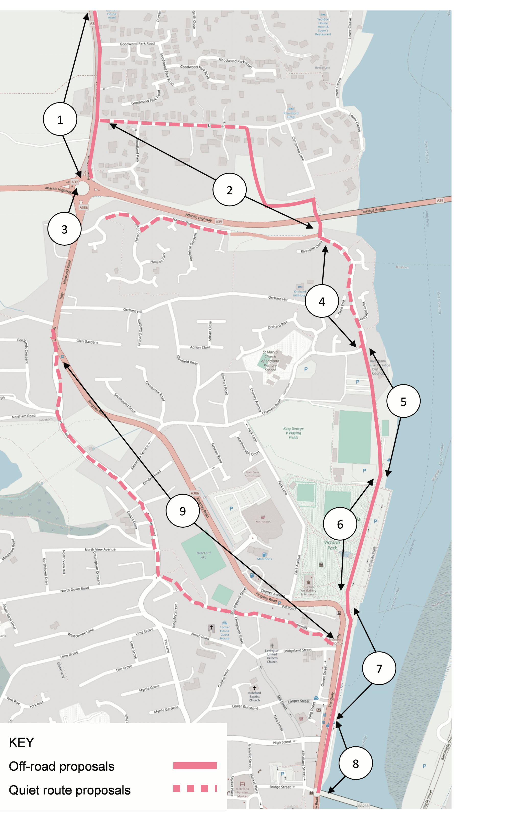
Section B

- Investigate potential for new cycle and pedestrian bridge or traffic reduction along Longbridge
- New shared use path
- Make Tarka Trail access accessible
- Signpost to quiet route
- Bring existing shared use path up to standard
- Widen existing shared use path
- Realign to better cycle access, signpost to quiet on-road route
- New shared use path, install modal filter
- New cycle route
- Signpost to quiet route
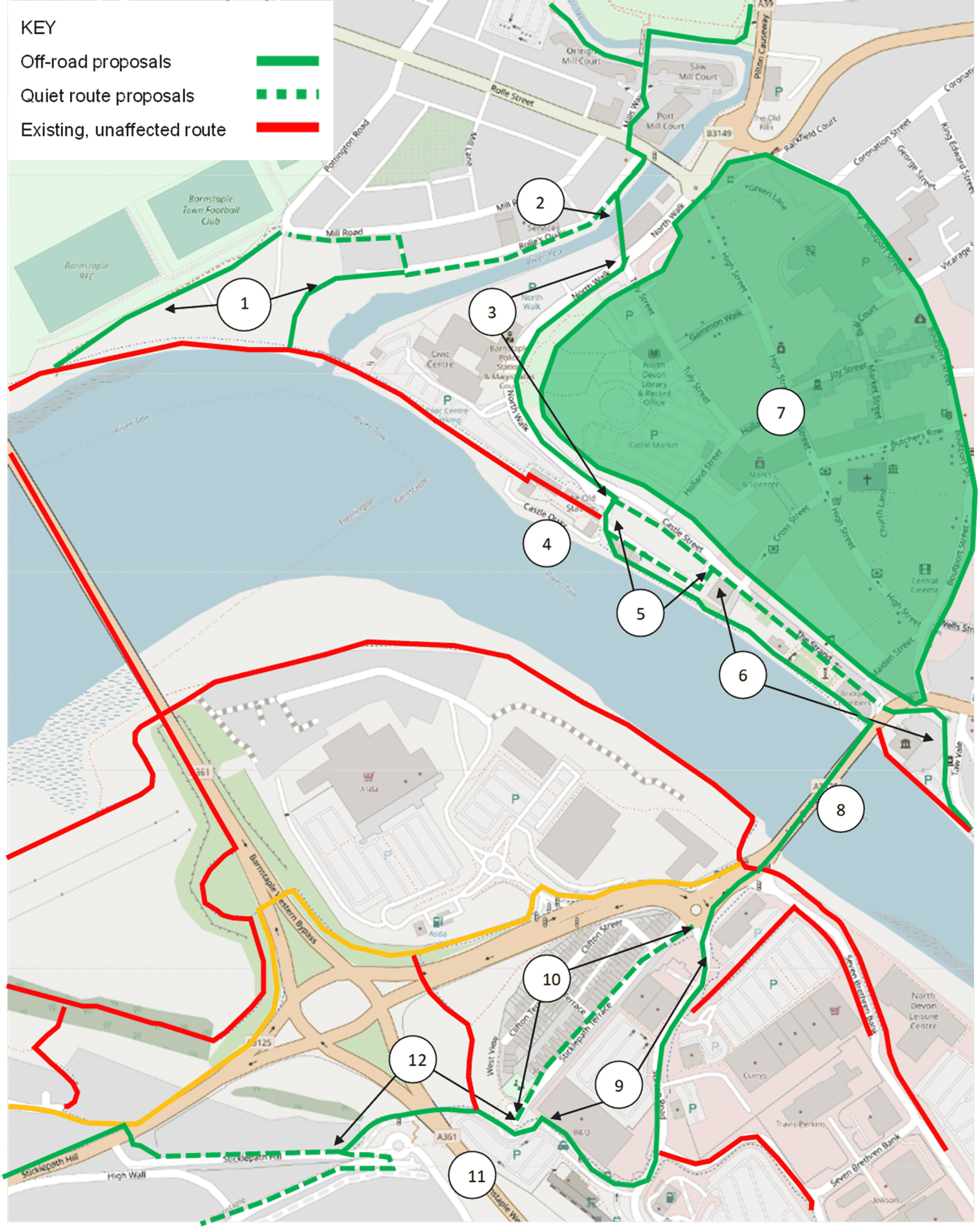
-
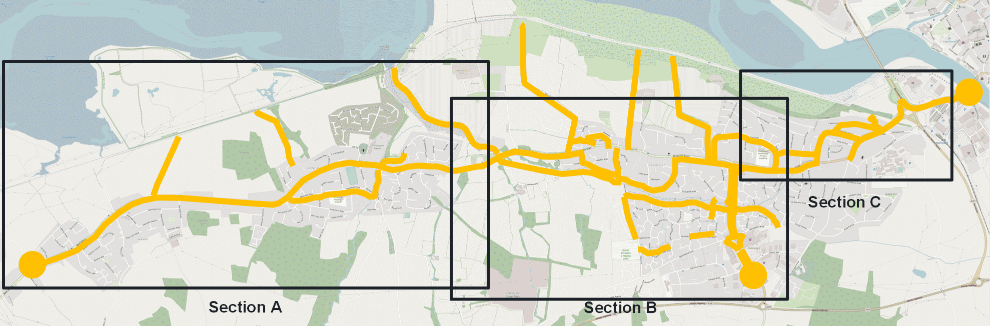
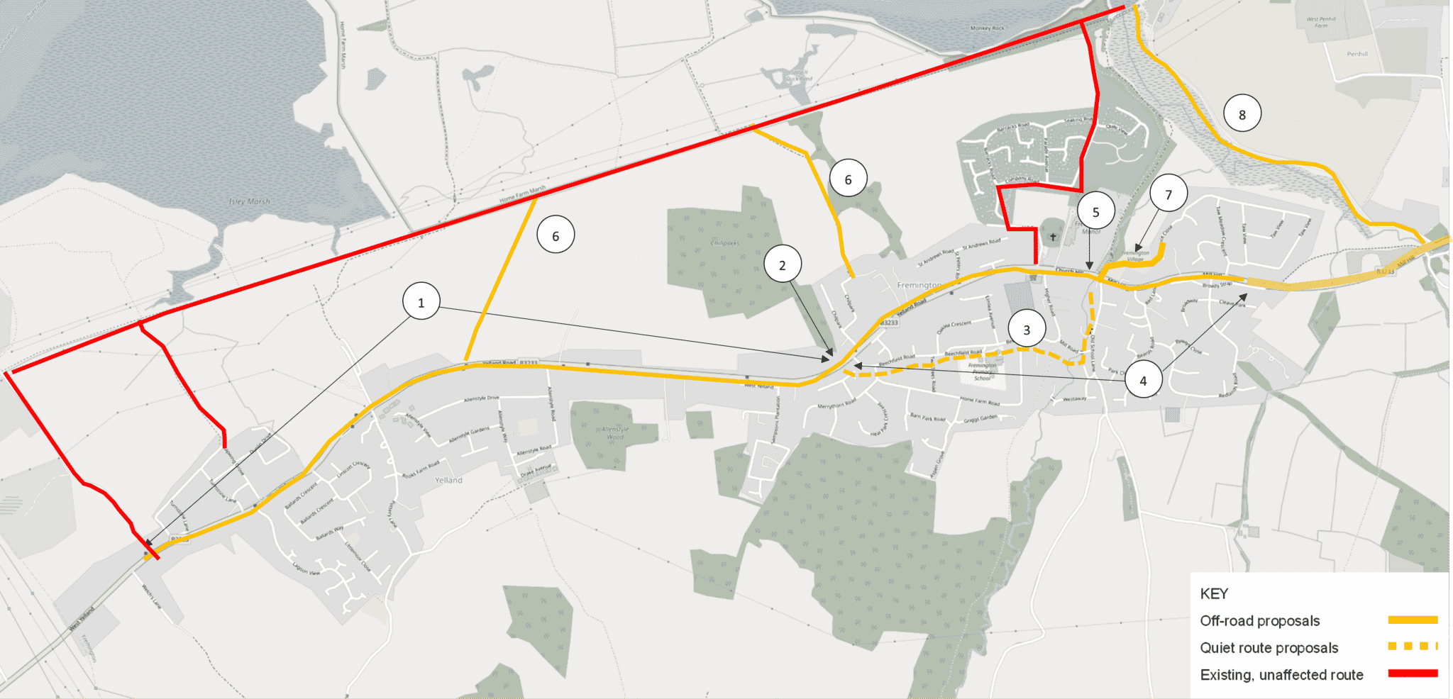
Yelland to Barnstaple

For full details on the proposals, please refer to page 26 of 68 in the Draft BBN LCWIP Report.
Section A

- New shared use path
- New crossing
- One way traffic except cyclists
- New shared use path with crossing
- New crossing
- Link to Tarka Trail
- New shared use path
- New shared use path
Section B

- Widen existing shared use path
- New off-road trail
- Give priority to cyclists along existing path
- Two new modal filters
- Signage to on-road link
- New shared use path with new crossing
- Signage to on-road link, with traffic calming measures
- Additional links to Tarka Trail, with new crossings
- Review barriers along existing network
- Convert existing footpath into shared use
Section C

- New shared use path
- Signage to on-road link
- New two-way segregated cycle route
- New shared use path with Toucan crossing
- Update signage, improve environment around underpasses
- Realign existing crossing or install parallel crossing
- Widen existing shared use path
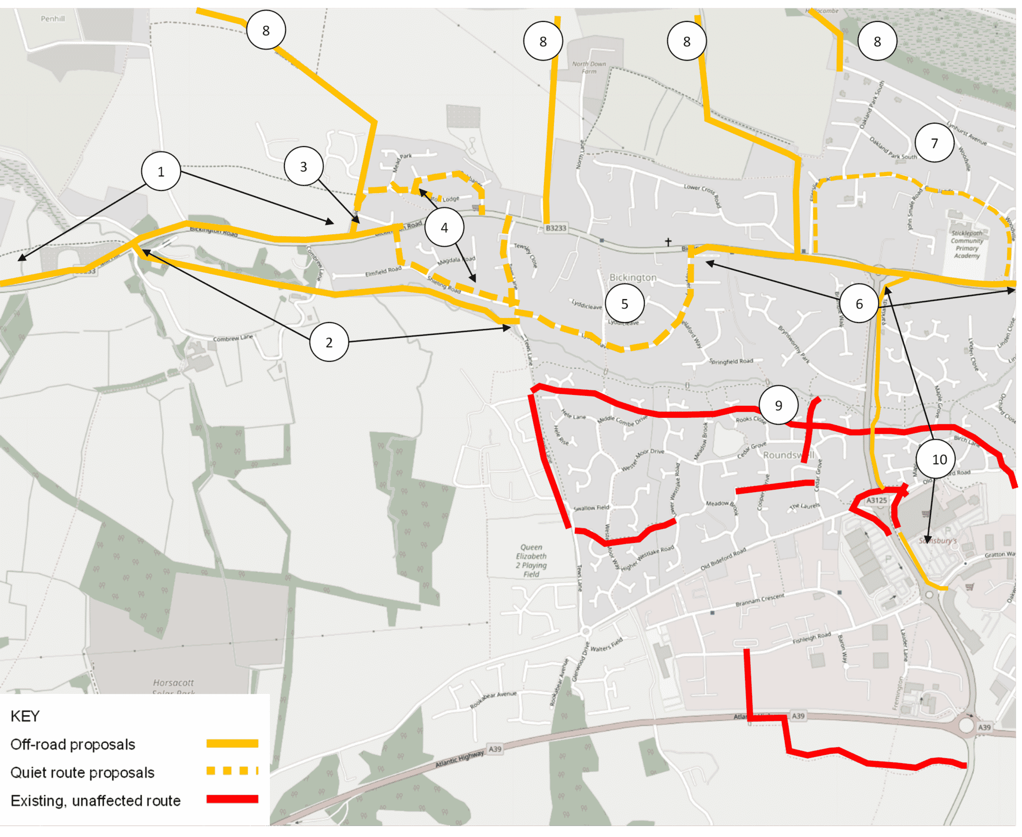
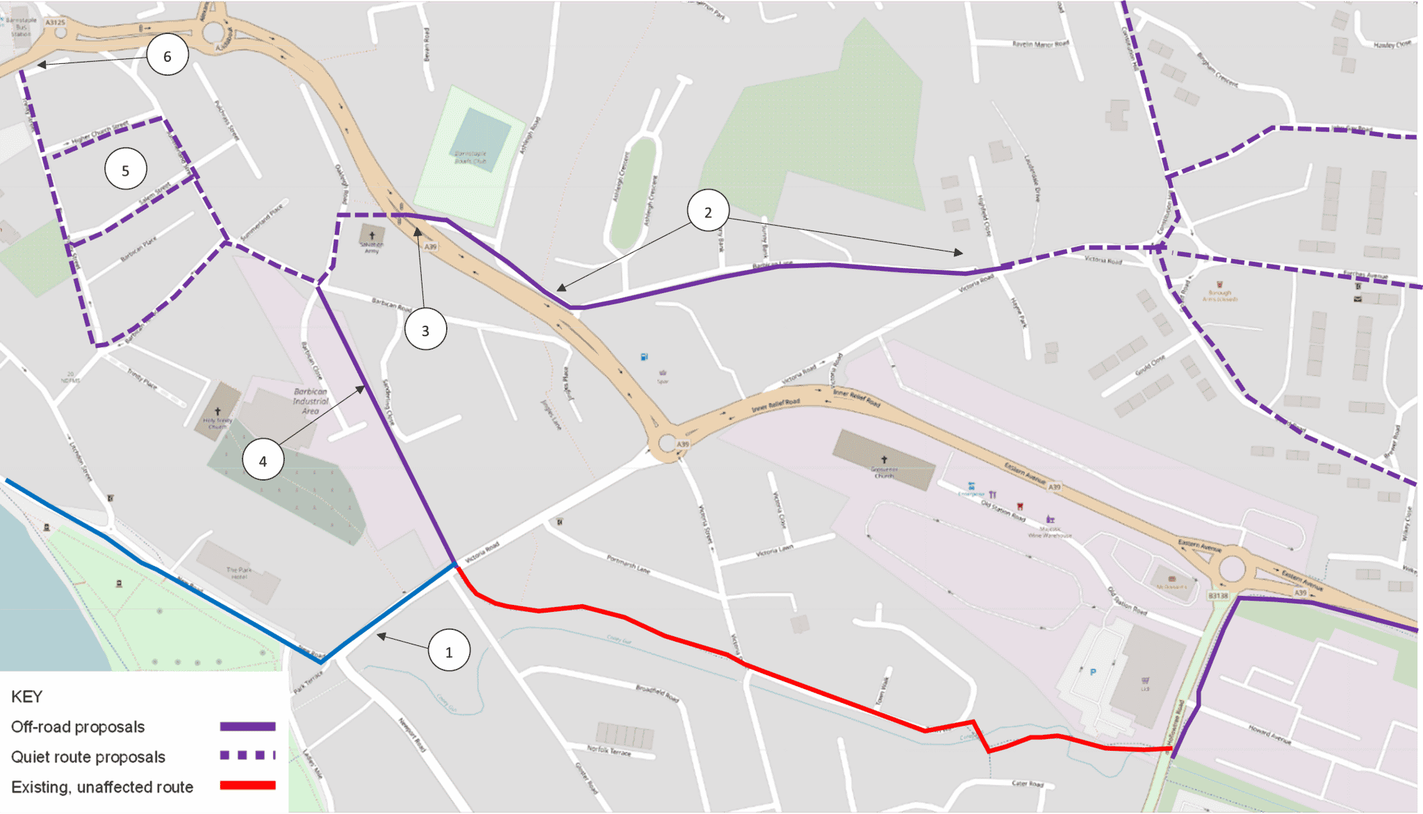
-
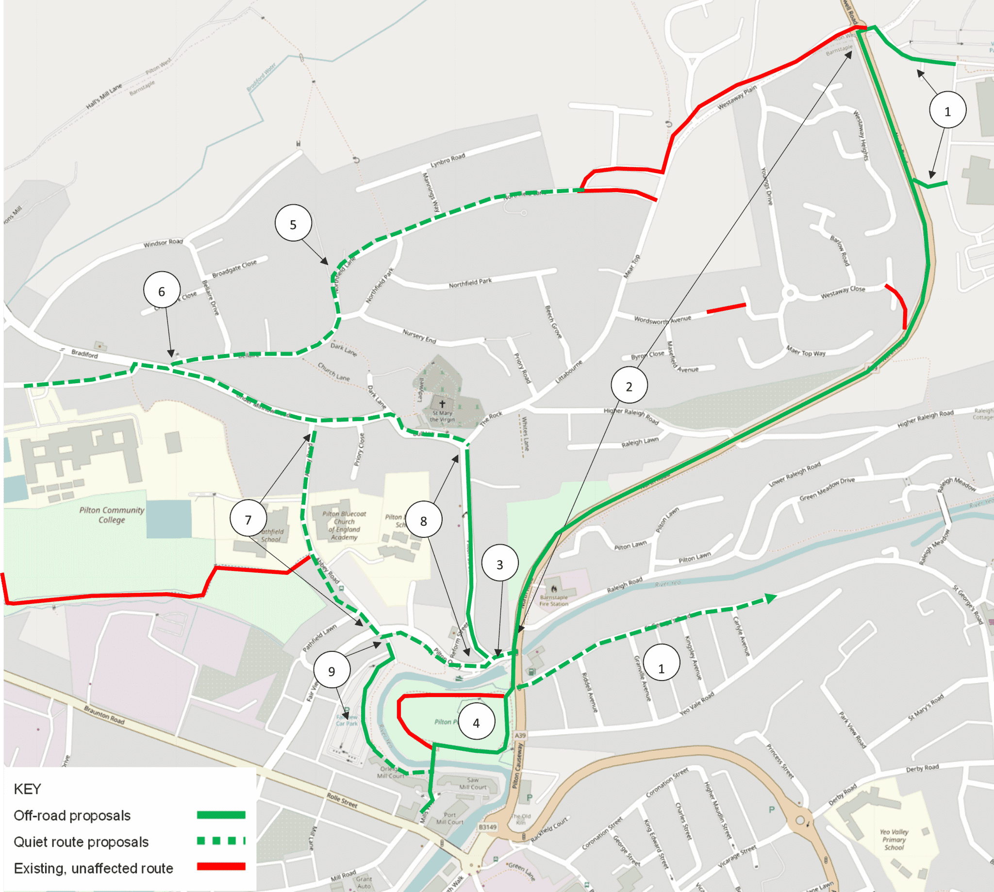
Roundswell to Pilton

For full details on the proposals, please refer to page 32 of 68 in the Draft BBN LCWIP Report.
Section A

- New separate cycle links
- Off-road cycle route, preferably a 2 way separated cycle link
- Realign existing crossing
- New entrance to Pilton Park for off road cycle route
- Modal filter or one-way system
- Improve visibility, possibly widen pavement
- Traffic calming
- One-way system with contraflow cycling
- New separate cycle path
- Review to create space
Section B

- Formal alternative cycle link
- Alternative cycle and pedestrian crossing
- New off-road cycle route
- Wider cycle access
- One-way system with contraflow cycle lane
- Formalise contraflow flow cycling and cycle crossing to off road route
- Create cohesive pedestrian and cycling environment
- Traffic free route
- Widen existing shared use path
- Signpost as primary route
- Review access to Rail Station
- Widen shared use path. Create pedestrian only link on the southern side
Section C

- Signage to quiet route
- Create new quiet route
- New shared use path
- New off road cycle link
- Signage to quiet route
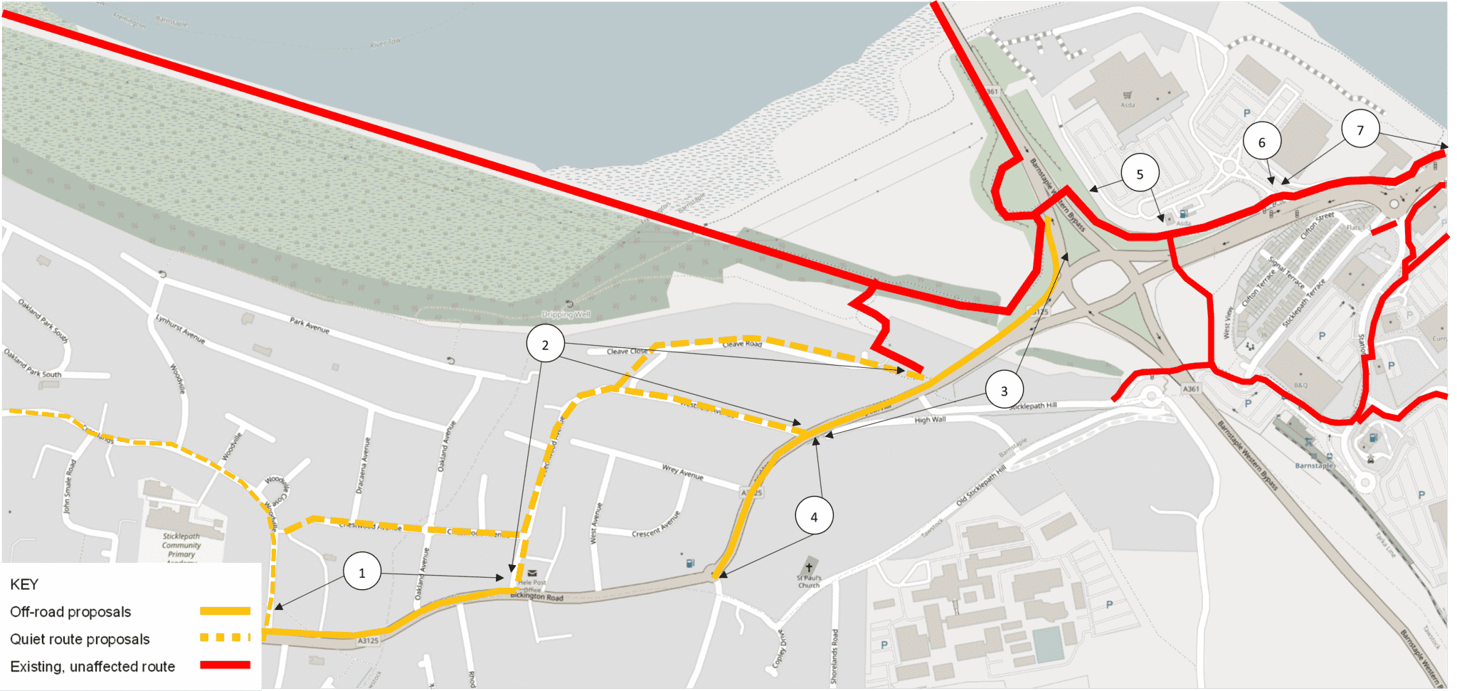
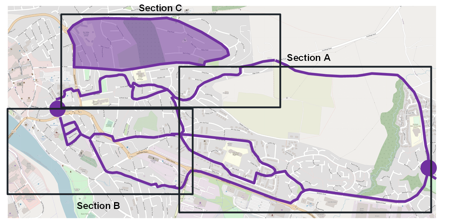
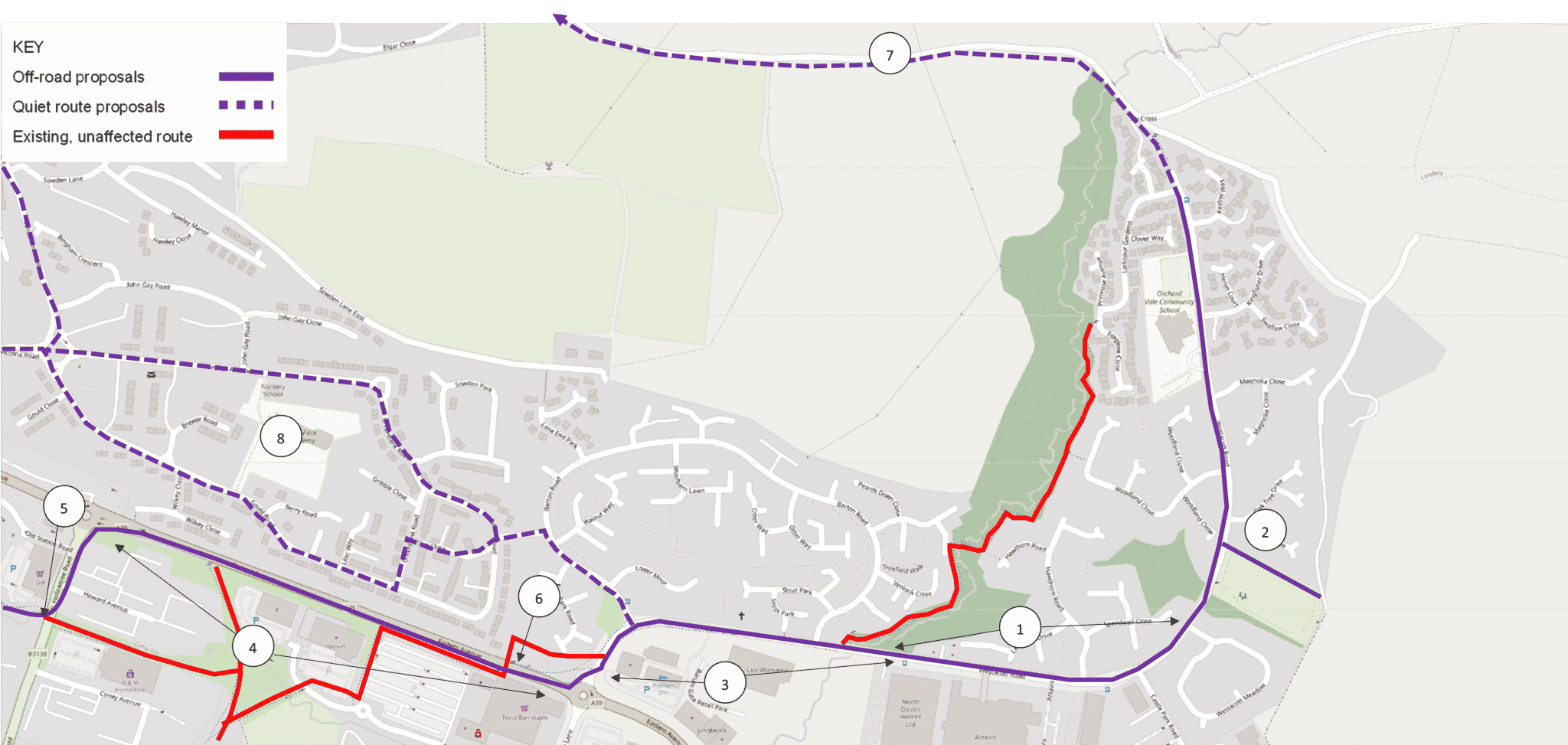
-
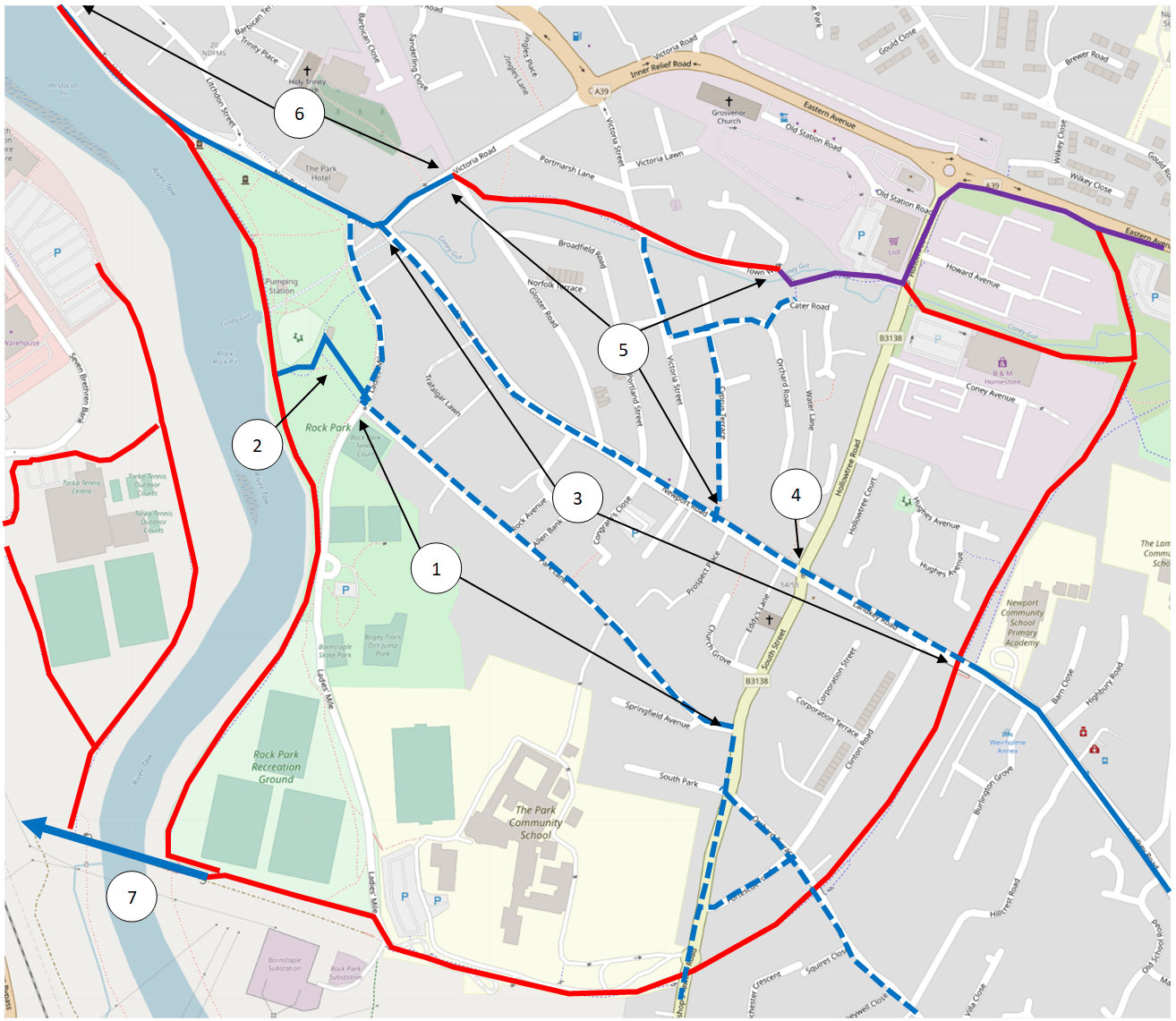
Whiddon Valley to Barnstaple

For full details on the proposals, please refer to page 37 of 68 in the Draft BBN LCWIP Report.
Section A

- New off-road route
- New cycle and pedestrian link
- Widen existing path
- New cycle path and shared use path
- Upgrade to standard the existing shared use path. New signalised crossing
- Improve existing underpass
- New green lane link
- Signpost quiet route network
Section B

- New off-road link
- Signpost low traffic route
- New signalised crossing
- Investigate opportunities for a cycle and pedestrian link
- Contraflow cycling
- Relocate existing crossing
Section C

- One-way traffic, wider footpath, contraflow cycle lane
- New shared use path
- Signpost quiet network
- Widen existing ramp and new shared use path
- New cycle crossing
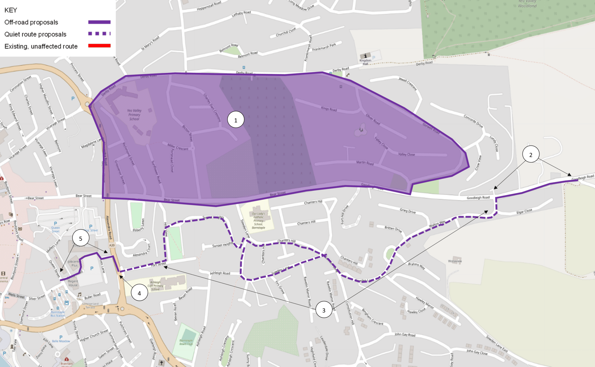
-
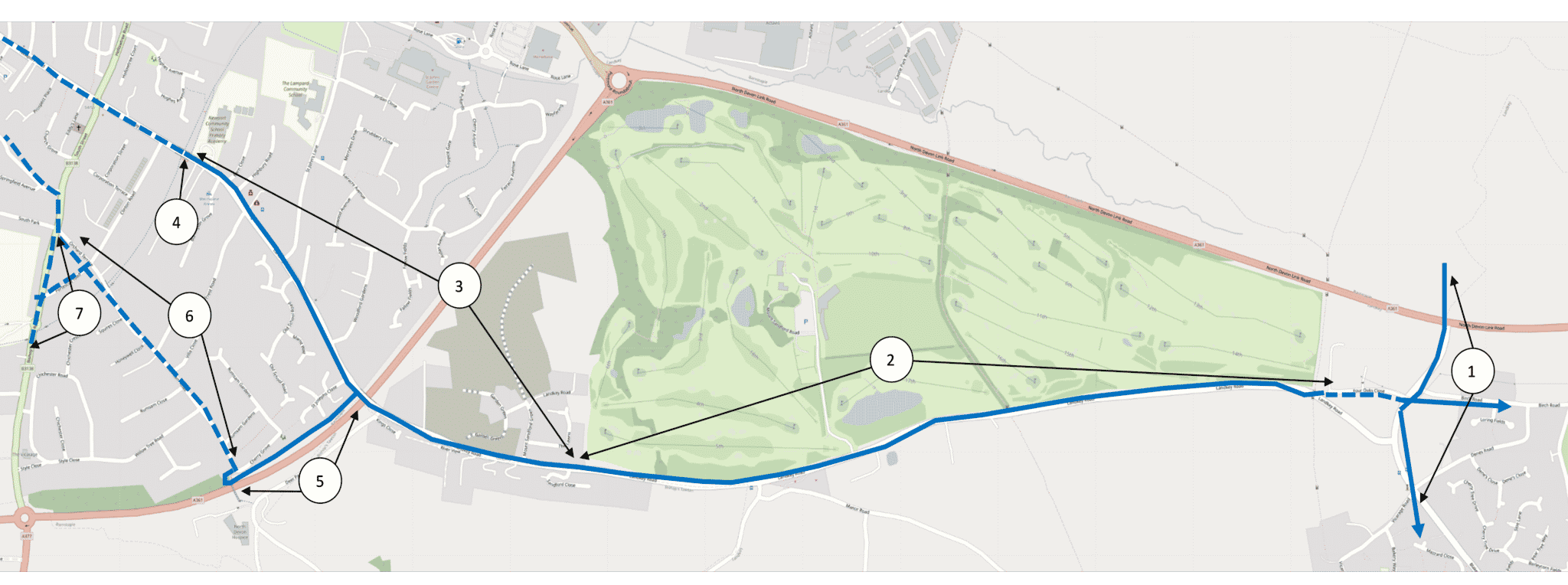
Landkey to Barnstaple

For full details on the proposals, please refer to page 42 of 68 in the Draft BBN LCWIP Report.
Section A

- Ensure off-road cycle and pedestrian links
- New shared use path with new crossing
- Extend footpath and widen shared use path, prioritise cycles at junctions, install raised crossings
- Review existing cycle access
- Improve existing shared use path access
- Signpost to quiet on-road route
- Widen footpath, slow traffic down
Section B

- Signpost to quiet route, improve accessibility
- Define new cycle link
- Slow traffic down
- New advance stop lines for cycles, review existing signal timings
- Signpost to quiet route
- New shared use path
- Ensure delivery of already proposed link
Cycling proposals
Below are the six cycling corridors within the LCWIP, with selected interventions highlighted for each. All these interventions are potential responses to gaps identified in the existing active travel network; they are aspirations and are not guaranteed to be progressed onto further stages of design.
Scheme prioritisation and costs
The interventions set out in the LCWIP are ambitious and will require external funding and further feasibility design work in order to be progressed further. It is therefore important that the interventions are prioritised.
Government guidance states that priority should be given to improvements that are most likely to have the greatest impact on increasing the number of people who choose to walk and cycle, and therefore the greatest return on investment.
Other factors may also influence the prioritisation of improvements such as the deliverability of the proposed works or opportunities to link with other schemes.
Routes were prioritised by section due to the benefits of delivering a complete and coherent cycle route, shown in the table below.
| Priority | Improvement | Approximate cost |
|---|---|---|
| 1 | Roundswell to Pilton: Section B (excludes improvement to Longbridge) | £9.0 |
| 2 | Appledore to Bideford: Section B | £3.8 |
| 3 | Alexandra Street core walking zone | £3.5 |
| 4 | Barbican Road and Queen Street core walking zone | £1.7 |
| 5 | Roundswell to Pilton: Section A | £5.0 |
| 6 | Whiddon Valley to Barnstaple: Section B | £1.5 |
| 7 | Whiddon Valley to Barnstaple: Section C | £2.9 |
| 8 | Yelland to Barnstaple: Section B | £7.3 |
| 9 | Landkey to Barnstaple: Section B | £1.1 |
| 10 | West Bideford to East-the-Water: Section A | £2.8 |
| 11 | Landkey to Barnstaple: Section A | £2.4 |
| 12 | Appledore to Bideford: Section A | £4.3 |
| 13 | Bideford core walking zone | £3.3 |
| 14 | West Bideford to East-the-Water: Section B | £7.5 |
| 15 | Yelland to Barnstaple: Section C | £3.2 |
| 16 | Whiddon Valley to Barnstaple: Section A | £3.3 |
| 17 | Roundswell to Pilton: Section C | £2.9 |
| 18 | Yelland to Barnstaple: Section A | £7.4 |
| 19 | Westward-Ho! core walking zone | £5.1 |
Accessibility
We take accessibility seriously and recognise that some of the information presented in the files available on this page may not be fully accessible to someone using assistive technology such as a screen reader.
If you need guidance or an alternative format, email transportplanning@devon.gov.uk or call on 01392 38 3000 (and ask for Katalin Fulop, between 10 am and 4 pm, Monday to Friday) with details of any preferred format and the assistive technology you use.
Documents
- Draft BBN LCWIP Report
- 8-page Leaflet that featured in the North Devon Gazette (21st September 2022 edition)
- Public Consultation Report (available from the 31st of October 2022)
- Questionnaire (as the consultation is closed, no more responses are accepted)
- The Introduction to LCWIP – 3 minutes youtube video
- Process of Network Planning for Walking and Cycling in Barnstaple – 8 minutes youtube video
- Process of Network Planning for Walking and Cycling in Bideford and Northam. – 8 minutes youtube video (same audio as the above, but uses maps in Bideford and Northam)
Email: transportplanning@devon.gov.uk
Phone: 01392 38 3000 (ask for Katalin Fulop, between 10am to 4pm, Monday to Friday)