Consultation
Barnfield Road Gateway
From
01/10/2025
Until
31/10/2025
A public consultation is being held on proposed changes to the layout of Barnfield Road, Exeter. This includes improvements to the active travel provision and the public realm, and changes to vehicular access.
There are details below of the proposals, and how you can give us your feedback.
Background
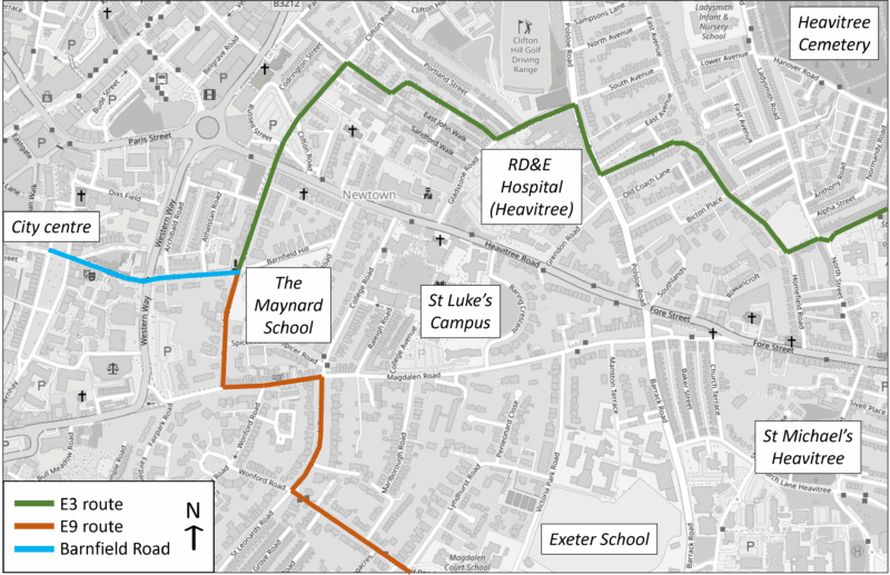
Barnfield Road is situated between Princesshay and Denmark Road, crossing Western Way. This is a vital link within Exeter and runs through the centre of Southernhay, connecting people travelling by car, cycle and on foot to the city centre. As part of the E3 and E9 strategic cycle routes (which can be seen in Image 2), it plays a crucial role in linking communities with workplaces and leisure. It is one of the main gateways into the city centre and gives visitors a first impression of the area.
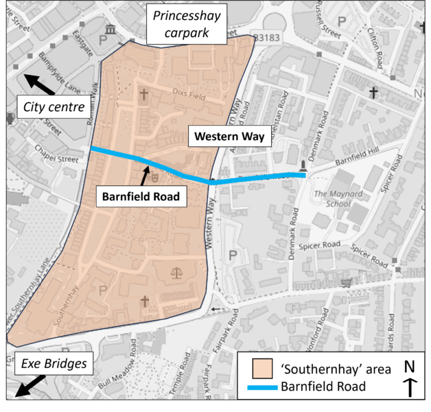
There is an opportunity to improve this area as an attractive gateway into the city centre. In particular, this will improve the safety and enjoyment of people walking, wheeling and cycling. A number of traffic counts that have been undertaken show that over 2,000 people walking and over 500 people cycling use this route everyday.
Devon County Council has undertaken a significant amount of work to understand the impacts of the proposed changes on the wider transport network.
The proposals have been designed to make Barnfield Road more accessible, attractive and safe for all. With the focus in mind to make all users feel welcome and relaxed when visiting the city centre via Barnfield Road.
Scheme development has been split into 3 phases, each of which are at different stages of design.
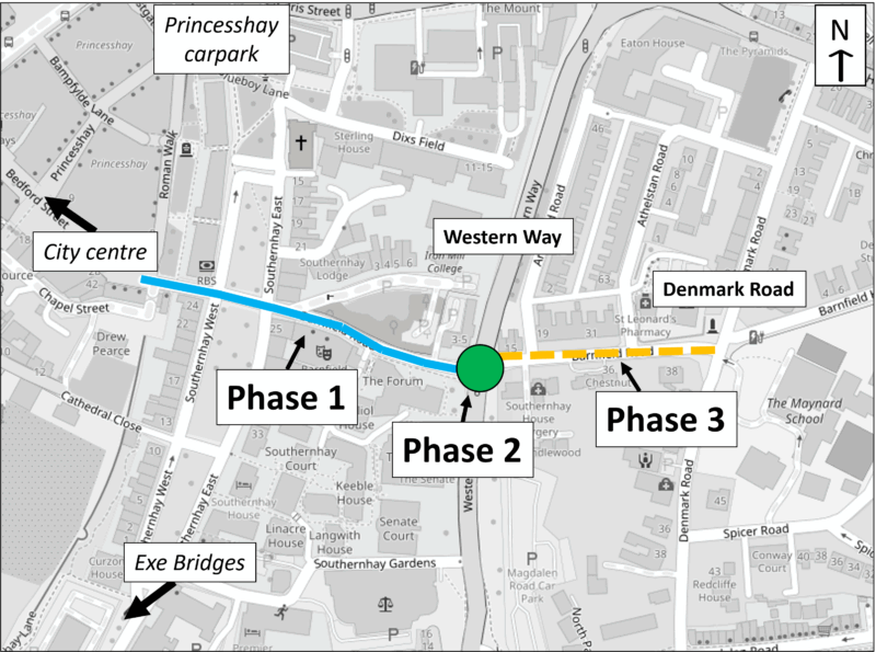
These are each detailed below.
- Phase 1: Barnfield Road – Princesshay to Western Way
The first phase of the project stretches from Princesshay to Western Way. This stage is almost fully designed and we have secured external funding for construction.
This stretch of road currently has two way traffic, and is subject to high levels of vehicular usage. Along with the narrow footways, poor cycle provision and lack of crossings, this makes the area feel unpleasant and unsafe.
To make the area feel more pleasant for users, a number of measures have been proposed, which can be viewed in the simplified scheme plan or are summarised in the table below:
Proposal Summary Widened Footways The proposed scheme includes widened footways on the northern edge of Barnfield Road, to ensure the footways are all two metres wide. This will give people walking more space, as well as improving access for mobility scooters and buggies. Improved Cycle Lanes Formalised cycle lanes will be introduced in both directions along Barnfield Road, and existing cycle lanes widened to two metres wide. These cycle lanes will be a mix of mandatory and advisory provision, to retain loading provision. This will allow people cyclists to feel safer and encourage people who are less confident to cycle the route. Improved Crossings New raised crossings will be installed across roads joining Barnfield Road, to allow people walking to take priority at the junction. This will make the roads easier to cross and will improve safety. One-Way Vehicular Flow To allow for the increase in width of both footways and cycle lanes, it is necessary to reduce the width of the carriageway. As a result, one lane of traffic will be removed and Barnfield Road will become westbound only towards Princesshay, between Western Way and Barnfield Crescent. This reduction in traffic will make the area more pleasant by reducing noise and pollution. This aspect of the scheme will require a statutory Traffic Regulation Order consultation in the future. Full details of this can be seen in the scheme plan, and will result in Barnfield Road looking like the visualisations below.
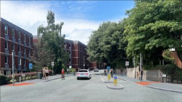
Image 4: Visualisation of the proposed scheme view, view from Western Way. (click on image to open in full screen) 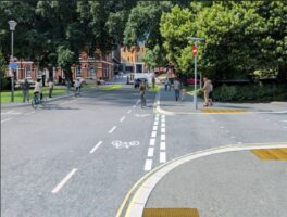
Image 5: Visualisation of the proposed scheme view, looking towards Princesshay. (click on image to open in full screen) Links to Other Projects
These proposals are designed alongside another scheme being promoted by Exeter City Council, which is returning the access to Princesshay carparks to its original layout. Currently, these carparks are accessed via Southernhay, which was a long-term temporary arrangement to reduce traffic on Paris Street whilst the Bus Station was being developed. It was agreed that the access to the Princesshay carparks will revert to the original access on Paris Street which will mean that the entrance at Southernhay is stopped up, and the one-way system along Southernhay East will be reinstated. These works are expecting to be undertaken in Autumn 2025.
The two projects combined will result in a dramatic reduction in the number of vehicles using Southernhay and Barnfield Road, and in a one-way system working as follows:
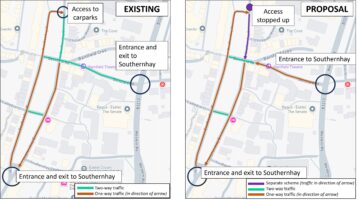
Image 6: Map showing the current and proposed traffic flow around Southernhay. (click on image to open in full screen) Previous Engagement
Previously, we have reached out to residents and businesses in the immediate area to try and understand their views on the type of scheme we should consider. The main feedback we received was that Barnfield Road has too much vehicular traffic on it to make some aspects of the scheme feasible, without causing major disruption and inconvenience, or even increasing congestion elsewhere in the city.
Following this, more work was done to try and understand this potential impact. This showed that 30% of vehicles using Barnfield Road in peak hours are doing so to access Princesshay carpark, or to use this access point to cut through to Paris Street. Therefore, following the Exeter City Council Princesshay Carpark Access scheme, traffic on Barnfield Road is expected to drop considerably. This means that the disruption caused by the Barnfield Road scheme will be reduced.
The Princesshay Carpark Access scheme is planned to be completed in winter of 2025. After this, further traffic counts and modelling will be undertaken along Barnfield Road, to understand if this has had a large impact on traffic flows, bringing them to an acceptable level.
Have your say
The first section of the questionnaire linked below is about this phase of the scheme.
- Phase 2: Barnfield Road Junction with Western Way
At the eastern end of Phase 1, Barnfield Road crosses over Western Way. This junction is very busy with motor traffic, as well as for people walking, wheeling and cycling. The primary route for people walking or cycling are crossing straight across Western Way as they travel east along Barnfield Road.
There is concern that the Western Way junction is confusing for people walking, wheeling and cycling to use, and makes them feel unsafe. We are therefore seeking views on potential improvements to enhance the experience for these users.
We are early in the design stage of this phase of the project and there is plenty of scope for the public to feed into this. There are many different aspects of the scheme we are considering, and the final design can be a combination of different options. We have summarised this is the table below:
Aspect of Design Details Cycle Markings Cycle markings across the junction to show where people cycling should go to cross straight across Western Way from one side of Barnfield Road to the other. This could be in the form of coloured painted routes or white line demarked routes. Segregation People walking and cycling will all be using the pavements on the eastern side of Western Way, but there is only a set amount of width available. Therefore, it needs to be decided if the entire pavement will be shared-use or if the pavement will be segregated into footway and cycle lane. Eastern Pavement There is currently a pavement running down the eastern side of Western Way. Whilst one option is to retain this footway, it is also an option to remove this footway. People walking would still be able to cross Western Way at the northern crossing point and travel directly down Barnfield Road. However, if people walking are planning to travel south along Western Way, they will have to cross Western Way at the southern crossing. Cyclist Stop Line People cycling westbound across Western Way currently stop at a stop line on the east of Western Way to wait for the lights to change. This allows people cycling to queue back as they wait for the cyclists phase of the traffic lights. There is an option to move this stop line closer to the road. We have prepared two visualisation to display how some of these elements can be combined. The final scheme design could be Option A, Option B or a different combination of elements.
Option A
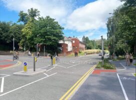
Image 7: Visualisation of Option A combination of proposals. (click on image to open in full screen) Option A combines to create a clearly regimented design that instructs people walking and cycling where to go and avoids conflict between them. This is achieved through:
- Segregated routes for people walking and cycling.
- Cycle routes across Western Way denoted by white road markings
- The footway along the eastern edge of Western Way has been blocked
- Cyclist stop line has been moved closer to Western Way, and is separate from people walking.
Option B
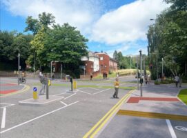
Image 8: Visualisation of Option B combination of proposals. (click on image to open in full screen) Option B provides a seamless interchange between people walking and cycling, allowing for freedom of direction. This is achieved through:
- Shared use paths for people walking, wheeling and cycling
- Cycle routes across Western Way denoted by coloured road surfacing
- Footway along the eastern edge of Western Way is retained
- Cyclist stop line has been moved closer to Western Way, although this is not separated from people walking.
Have your say
The second section of the questionnaire linked below is about this phase of the scheme.
- Phase 3: Barnfield Road – Western Way to Denmark Road
Phase 3 of this project focuses on the stretch of Barnfield Road between Western Way and Denmark Road. This stretch of road is relatively quiet as it is not open to through-traffic and is predominantly a residential area. However, there is concern this is not easy to navigate and could be improved for people walking, wheeling and cycling.
We currently have no designs or plans on how to improve this stretch of the road, but we do know that due to the low vehicle numbers, and low speeds, we will only need light-touch measures.
DCC would like to reach out to users to ascertain the types of improvements that the public and residents would wish to see. In the final section of the Have Your Say questionnaire, there is a chance to tell us how you think we can improve this final stretch of Barnfield Road.
Have your say
To respond to this consultation, please fill in the questionnaire.
If you would like a paper copy of the questionnaire, you can either print it yourself or please get in touch either by phone, post or email, and we will send a copy out to you.
To talk to our team in-person about this project, please come drop in to our exhibit in Princesshay. We will be at the west end of Bedford Street (outside the former Debenhams building) on Tuesday 21st October, from 11:30 to 18:30.
You can also send us feedback via email or post:
- Address: Transport Planning, Devon County Council, County Hall, Topsham Road, Exeter, EX2 4QD.
- Email: transportplanning@devon.gov.uk
Next steps
Follow this consultation, all results and feedback will be analysed and taken into account when moving towards the next stage of design.
For Phase 1 (Princesshay to Western Way) this will mean finalising the design to move towards construction.
For Phase 2 (Junction with Western Way) this will mean working out which elements are most popular and combing them to form a detailed design.
For Phase 3 (Western Way to Denmark Road) this will allow us to understand what the public wants in this space, and begin to design it.
Accessibility
We take accessibility seriously and recognise that some of the information presented in the files available on this page may not be fully accessible to someone using assistive technology such as a screen reader.
If you need guidance or an alternative format, email transportplanning@devon.gov.uk with details of any preferred format and the assistive technology you use.
Contact
Address: Transport Planning, Devon County Council, County Hall, Topsham Road, Exeter, EX2 4QD.
Email: transportplanning@devon.gov.uk
Phone: 0345 155 1004