Introduction
The A379 Bridge Road is an important route within Exeter, providing one of only four crossings over the River Exe. It plays a key role supporting daily travel between residential, employment and commercial areas, including Marsh Barton, Newcourt and Sowton, while also providing links between Exeter and the wider South Devon area. Bridge Road also plays a crucial role when there are disruptions on the M5 (between junction 29 and 31), being the official diversion route and offering an alternative to keep traffic moving.
We are seeking your views on a series of proposed improvements along A379 Bridge Road, particularly in relation to walking, wheeling, cycling and public transport. Your feedback is essential for shaping the proposals as the scheme develops.
Scheme overview
We are proposing to replace the two canal bridges (a swing bridge and bascule “lifting” bridge) with two bascule bridges and where possible introduce improved facilities for walking, wheeling, cycling and public transport. This would help to address long-term issues with the reliability, safety, accessibility and resilience of the current bridges.
The A379 Bridge Road scheme would aim to:
- Provide a reliable and resilient crossing of the Exeter Canal and surrounding road network by maintaining two lanes of traffic in both directions across the canal bridges
- Improve safety for all users along Bridge Road
- Improve the environment for people walking, wheeling and cycling, including those using the Exe Estuary Trail and other local routes
- Provide a reliable diversion route when there are incidents or delays on the M5
- Support the efficient movement of vessels on the canal for leisure and ferry traffic
- Reduce the ongoing costs of maintaining the bridges and avoid the likelihood of any unplanned bridge closures and associated disruption caused as a result
- Enable the planned development near Bridge Road to be built and occupied
Why are improvements needed?
The existing bridges are ageing and already operating past their life expectancy: the swing bridge is 90 years old and the bascule “lifting bridge” is 54 years old. They were originally placed as temporary structures when the M5 viaduct was being built. Nowadays, the bridges are increasingly prone to faults, which can cause delays and disruption for people using the route, including motorists, boats, pedestrians and cyclists. These issues also lead to higher maintenance costs and affect the reliability of the wider road network.
Since 2020, there have been more than 100 maintenance visits to the bridges to repair faults. These works often require lane closures and traffic management, increasing congestion and journey times. With annual maintenance costs of £115k and costs continuing to rise year-on-year, maintaining the bridges is placing growing pressure on our limited bridge maintenance budget.
Without investment, the condition of the bridges would continue to worsen. This could lead to more frequent unplanned closures and safety concerns, while journey time delays are also forecast to increase. In the future, the carriageway may need to be reduced to one lane in each direction and weight restrictions may also be needed, preventing buses and heavy goods vehicles from using the route and diverting traffic onto longer, less suitable roads.
Bridge proposals
To identify the preferred option for the scheme, our designers and engineers have investigated five different bridge options. These were each assessed against the following criteria:
- Suitability – alignment with scheme objectives
- Deliverability – cost, potential land take, construction feasibility
- Acceptability – environmental, social and user impacts
A summary of the five options is provided in the table below.
| Option | Description | Progressed or Discounted | Reason |
| Option 1 | Replacing the bridge as it is in its current form. | Discounted | Significant construction disruption and would not improve safety or active travel or allow better traffic flows during maintenance. |
| Option 2 | Replacing the bridges at the existing road level. | Progressed for further development | Improves safety and active travel potential, less environmental impacts, and more cost-effective. |
| Option 3 | Replacing the bridges and raising the road level. | Discounted | Significant land take and substantial environmental and landscape impacts. |
| Option 4 | Replacing the bridges at a marginally raised level. | Discounted following additional investigation | Significant land take and environmental and landscape issues. |
| Option 5 | Refurbishing the existing bridges to extend their lifespan. | Discounted | Temporary solution that would not address long-term safety, resilience, accessibility or active travel issues. |
Option 4 looked at replacing the bridges at a slightly higher level than they are currently. This would create space for an underpass below the bridge which could be used by pedestrians and cyclists. This option was investigated further but was eventually discounted for the following reasons:
- More expensive to deliver
- Safety concerns for users of the underpass
- Risk of the underpass flooding
- Requires more land
- Greater environmental impact
- Active Travel England suggested that this was not a preferred option
- Cyclists would need to make a significant diversion away from their desired route to reach the new level of the bridge to cross the canal
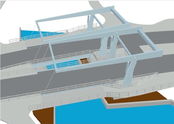
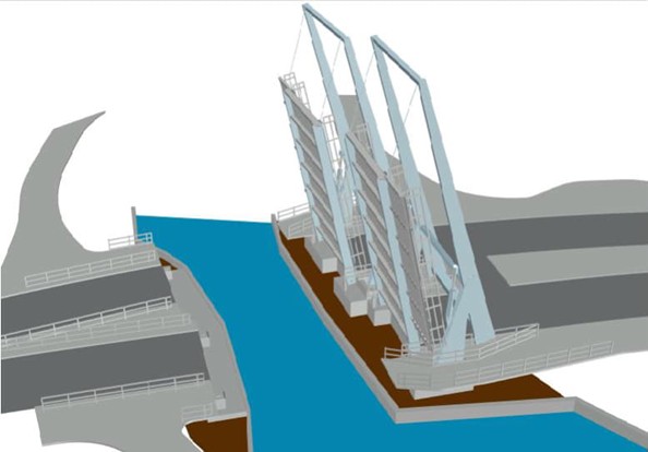
The proposed option, which best fulfils the criteria, is to replace the two ageing bridges at the same road level with two new bascule ‘lifting’ bridges (Figure 1 and Figure 2) that are designed to last more than 60 years. The road layout would be adjusted and slightly widened so that two-way traffic can be maintained, even when one bridge is closed for maintenance. This would allow vessels to pass underneath the bridges similar to the existing situation, but the bridges would be more reliable and quicker at opening and closing.
This option would:
- Improve safety
- Make it easier and more convenient for people to walk, wheel and cycle
- Require the least land
- Offer the best value for money
- Add resilience to the road network
It would also deliver improvements with a low carbon impact, protect the local environment and align with climate goals.
A full construction plan for the bridges would be developed in due course, once the scheme is approved.
Building the new bridges
At this stage, we expect that the bridges would be constructed one at a time to maintain access: the south bridge would be demolished first, while traffic is allowed to flow in both directions on the north bridge. Once the new south bridge is finished, traffic would switch to this bridge, and the north bridge would be constructed. All work is expected to take just under two years. Pedestrian and cycle access across the canal will be maintained at all times but the ability to open the bridges to allow larger vessels to pass underneath may be lost at times during construction.
Walking, wheeling, cycling and public transport
Replacing the bridges would create opportunities along the A379 Bridge Road to improve walking, wheeling, cycling and public transport. These measures would improve links to new and existing cycling routes, including the Exe Estuary Trail and National Cycle Network Routes 2 and 34. They would also make it easier for people to reach local leisure facilities, such as the new football pitches at King George V Playing Fields which are currently going through the planning process.
The measures proposed would help to make walking, wheeling, cycling and bus travel safer, more attractive and convenient, helping more people to choose these options for their everyday journeys. Two lanes of traffic would remain in both directions.
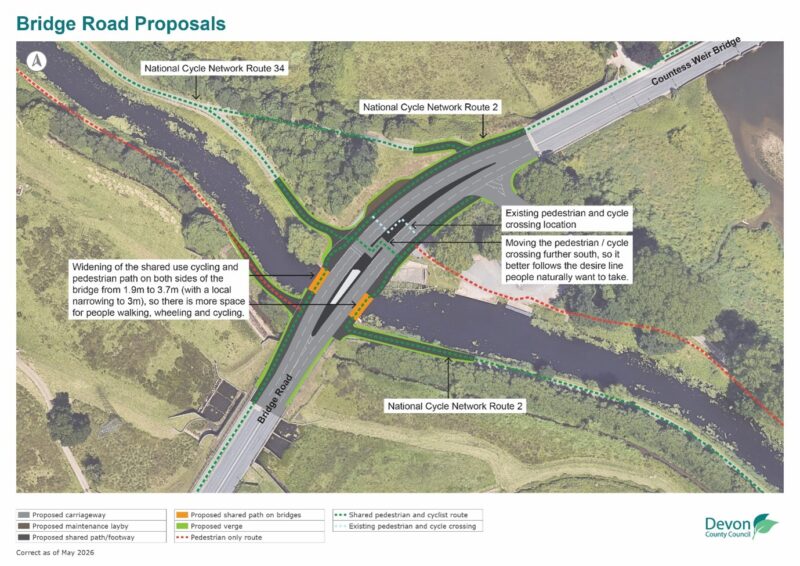
The following measures are proposed on the bridges (Figure 3):
- Widening of the shared use cycling and pedestrian path on both sides of the bridge from 1.9m to 3.7m (with a local narrowing to 3m), so there is more space for people walking, wheeling and cycling.
- Moving the pedestrian / cycle crossing further south, so it better follows the desire line people naturally want to take.
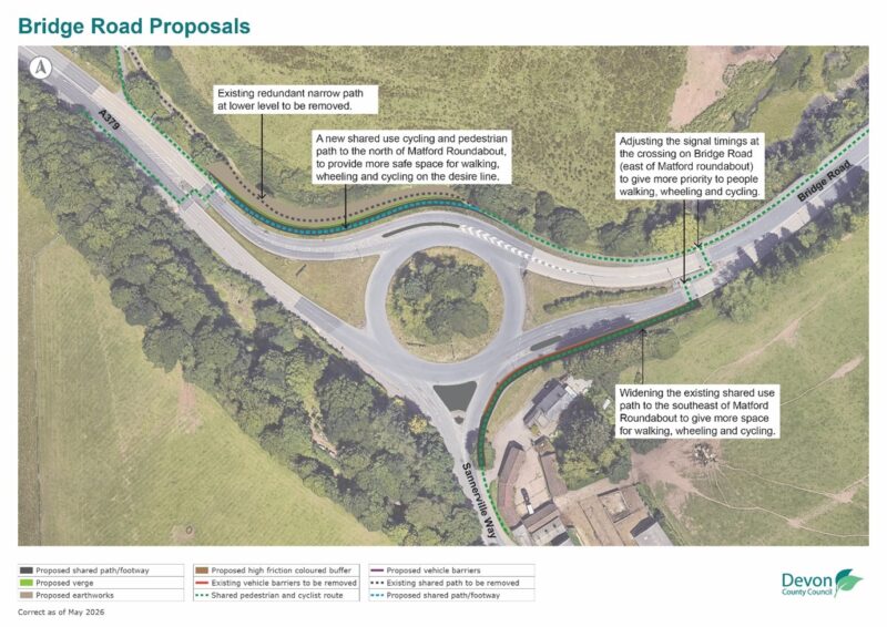
The following measures are proposed to the south of the bridges (Figure 4):
- A new shared use cycling and pedestrian path to the north of Matford Roundabout, to provide more safe space for walking, wheeling and cycling on the desire line.
- Widening the existing shared use path to the southeast of Matford Roundabout to give more space for walking, wheeling and cycling.
- Adjusting the signal timings at the crossing on Bridge Road (east of Matford roundabout) to give more priority to people walking, wheeling and cycling.
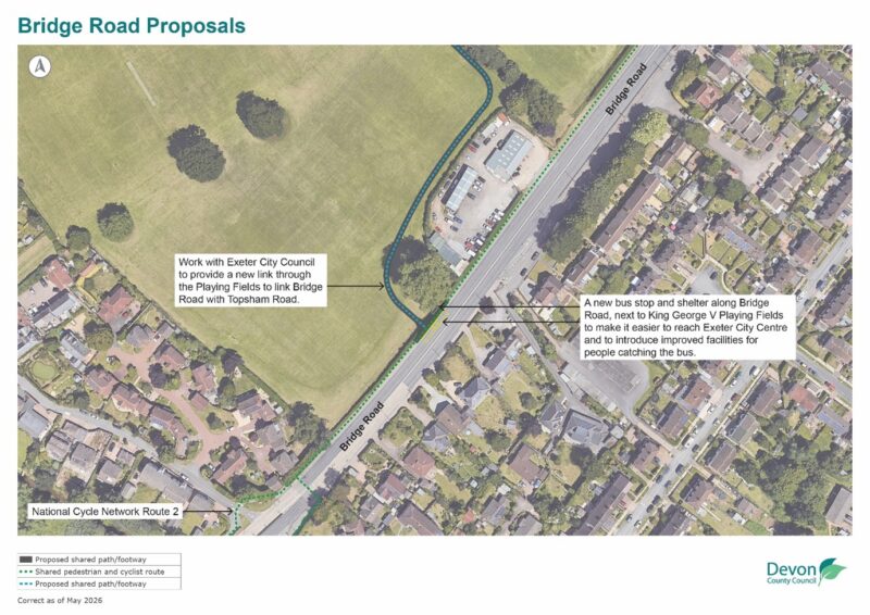
The following measures are proposed to the north of the bridges (Figure 5):
- A new bus stop and shelter along Bridge Road, next to King George V Playing Fields to make it easier to reach Exeter City Centre and to introduce improved facilities for people catching the bus.
- Work with Exeter City Council to provide a new link through the Playing Fields to link Bridge Road with Topsham Road
As part of the consultation, you have the opportunity to suggest additional improvements for walking, wheeling, cycling and public transport. We will review all ideas to see what can be taken forward.
Have your say
We are seeking your views on the proposed improvements.
Your feedback will help refine the proposals, particularly in relation to walking, wheeling and cycling improvements and how the scheme works in practice.
Take part in the consultation by completing the online feedback form:
A379 Bridge Road, Exeter | Commonplace
You can also attend one of our public consultation events that are happening on the 30 June between 15:00pm – 19:00pm and 1 July between 12:00pm and 16:00pm at the Exeter University Boat Club, Bridge Road, EX2 7BZ.
Email transportplanning-mailbox@devon.gov.uk
Or send a written response to FAO Transport Planning, A379 Bridge Road Consultation, Devon County Council, County Hall, Topsham Road, Exeter, EX2 4QD.
Next steps
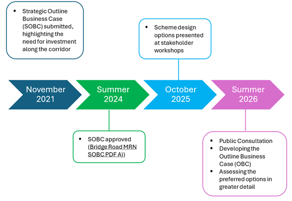
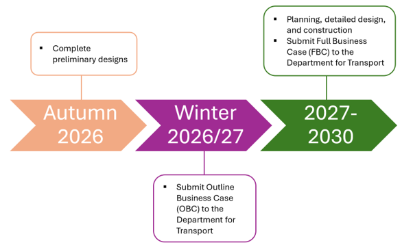
The figure below outlines how the A379 Bridge Road scheme has developed over the past five years, from the Strategic Outline Business Case (SOBC) to the current public consultation. Following the consultation, your feedback will be reviewed and used to shape the proposals ahead of submission of the Outline Business Case (OBC) in winter 2026. More detailed design work will then be undertaken, with construction currently planned to begin in spring 2029, subject to approval from the Department for Transport.
The current cost estimate for the scheme is £42 million with the project being funded through the Department for Transport’s Major Road Network (MRN) Fund. The MRN fund has an upper cap of £50 million and therefore the scheme costs need to remain below that threshold. Devon County Council is required to contribute a minimum of 15% towards the total project cost.
Active Travel routes – Engineering plans
UK0028605_5045-WSP-GEN-BB-DR-CH-0001.pdf
UK0028605_5045-WSP-GEN-NAT-DR-CH-0001.pdf
UK0028605_5045-WSP-GEN-SAT-DR-CH-0001.pdf
Bridge proposal – Engineering plans
Email: transportplanning@devon.gov.uk