Consultation
Pinhoe Road and Honiton Road Bus Corridors Improvements and Crossings
From
19/02/2024
Until
29/03/2024
Project Update
This consultation is now closed. Thank you to everyone who responded.
The full consultation report can be found here: Consultation Report
Following consultation feedback, the bus corridor improvement proposals were taken to July 2024 Devon County Council Cabinet (Item 573). The Cabinet Report can be found here: Cabinet Report
The active travel crossing proposals are on a slower trajectory, and are currently still in the design phase following consultation.
The public consultation opened on Monday 19 February and closed Friday 29 March 2024.
Introduction
In March 2021, the Department for Transport (DfT) announced the National Bus Strategy for England – “Bus Back Better”. It aims to deliver better bus services for passengers through a reform of how bus services are planned and delivered. The strategy set out the requirements for all local transport authorities to publish a Bus Service Improvement Plan (BSIP). Devon County Council’s BSIP was first published in October 2021 and outlines the need to deliver bus service improvements including infrastructure enhancements and bus priority measures. The BSIP strategy includes four bus corridors in Exeter which are being improved with funding from central government: Central, Eastern, Northern and Western. This consultation covers two of those bus corridors; Central and Eastern.
The Exeter Central Bus Corridor is approximately 3km (1.9 miles) in length between Paris Street Roundabout and Middlemoor Roundabout, predominantly along Honiton Road and Heavitree Road. The bus corridor has up to 30 buses an hour in each direction Mondays to Saturdays.
The Exeter Eastern Bus Corridor is approximately 3.4km (2.1 miles) in length between Sidwell Street and Pinhoe Sainsbury’s predominantly along Pinhoe Road (B3212) which has up to 18 buses per hour (two-way total) running along it Monday to Saturday.
Two active travel crossings are being consulted on at the same time as the bus improvement proposals. These are a part of the Exeter Local Cycling and Walking Infrastructure Plan (LCWIP), which was adopted at Cabinet in early 2024. You can find out more about the Exeter LCWIP by clicking here. The active travel crossings are located at Polsloe Bridge (crossing Pinhoe Road) and at the Honiton Road / Rifford Road junction (crossing Honiton Road). Both crossings form part of the E12 Strategic Cycle Route. The active travel crossing designs have been funded from Central Government funding; however, detailed design, and construction will be progressed when additional funding is obtained.
Further details can be found in the proposals section.
An overview map can be found here: Consultation Overview Map
Project aims
The proposed improvements will help:
- Make bus a more attractive travel choice by reducing journey times and making trips more reliable.
- Promote healthier and more sustainable community-wide travel choices by offering safe, conveniently located crossings for people walking and cycling.
- Create an active travel network that meets the needs of all potential users.
- Accommodate local housing growth and deliver economic benefits for the community.
Proposals
-
Exeter Central Bus Corridor (Honiton Road and Heavitree Road Corridor)
Exeter Central Bus Corridor (Honiton Road and Heavitree Road Corridor)
The Exeter Central Bus Corridor is approximately 3km in length between Paris Street Roundabout and the Middlemoor Roundabout, predominantly along Heavitree Road and Honiton Road
This bus corridor regularly experiences congestion due to the demand for vehicle movements exceeding the limited road space available. These proposals aim to improve priority and journey times for buses as well as address road safety difficulties for people walking and cycling on busy routes.
We are asking for your thoughts on the following proposals through the consultation process:
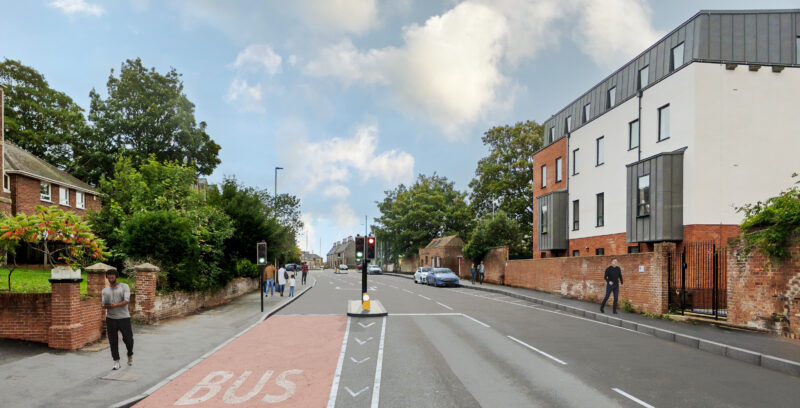
- Introduction of bus priority pre-signals at the end of the Heavitree Road bus lane. At this location, buses are delayed waiting for gaps in the traffic to turn into Barrack Road, with up to 9 buses per hour making this movement. Under this proposal, when a bus approaches, general outbound traffic would be signalled to stop in coordination with the junction signal control. Thereby creating an opening in the traffic for the bus to proceed more easily by reducing the conflict between buses moving into the right turn lane and vehicles moving into the left turn and straight on lane.

An Artistic Impression of Proposed Heavitree Road Bus Priority Pre-Signals - Relocation of the existing bus stop at Livery Dole, which would merge this stop with the one near Grendon Road. This change is required to enable space for the bus priority signals at the end of the Heavitree Road bus lane and reduce loss of parking.
- Provision of an additional northbound lane and bus lane on Barrack Road. This proposal would directly benefit nine buses per hour that make the left turn from Barrack Road to Heavitree Road. The additional lane would be created by removing the eastern footway (between Heavitree Road and Magdalen Road junctions) and the uncontrolled crossing point on the Heavitree Road and Barrack Road junction. The western footway and signalised crossing will be maintained.

An Artistic Impression of Proposed Left Turn Bus Lane on Barrack Road at the Junction with Heavitree Road - Changes to bus lane operational times for Honiton Road and Fore Street:
- Honiton Road Inbound – Hill Barton Road Overbridge to Ringswell Avenue: Change to Monday to Saturday 7am to 10am (extension of current hours which are Monday to Friday 8am to 9:15am).
- Fore Street Inbound – Butts Road to Church Street: Change to (extension of current hours which are Monday to Friday 8am to 9:30am and 4pm to 6:30pm):
- Option 1: Monday to Saturday 7am to 10am and 3pm to 7pm
- Option 2: Monday to Saturday 7am to 7pm
To complement the above proposals a range of smart technology measures are also planned:
- Bus priority technology designed to make traffic flow smoother. This helps buses by making the green traffic signal last longer, so they can cross the stop line without waiting for the next cycle. This technology can also be set up to reduce waiting times for buses stuck at stop lines, ensuring minimal disruption and delays to other users.
- Adaptive traffic control solutions using CCTV cameras to monitor both junctions and corridor operations. This would allow the Council to track how long it takes vehicles to travel through these areas, coordinate traffic signals, and use technology upgrades to give buses priority along a route or corridor. In addition, several traffic corridors will benefit from the Moving Traffic Enforcement policy that is currently awaiting approval from the Department for Transport (DfT). If the policy is approved, Devon County Council will have the power to fine drivers for traffic offences, using the cameras installed along the corridors to help with enforcement.
- Variable Message Signs (VMS) would be improved as a part of the BSIP in the Central Bus Corridor Route. These signs would be upgraded to inform drivers about real-time traffic conditions, journey times for the corridor, and congestion data from the Urban Traffic Control system. The aim is to encourage drivers to reroute during busy periods, reducing traffic and congestion on the corridor.
There are some additional improvements suggested that could support the development of the Central Bus Corridor improvements. These are considered ‘quick fixes’ and can be added to the programme if there is enough funding available.
- Improvements to the North Street approach onto Fore Street junction, to aid buses turning right.
- Relocation of the loading bay on Fore Street to allow vehicles to pass traffic that is waiting to enter the Tesco Express Garage.
- Renewal and improvement of the bus lane road markings on Honiton Road
- Improvement of the bus stop infrastructure on the Central Bus Corridor, including upgrades to shelters and real-time bus information.
Journey Time Benefits:
This project aims to significantly improve bus journey times with the introduction of technology measures and infrastructure. For the Exeter Central Bus Corridor, there is potential for an approximate four-minute journey time saving per bus.
Technology Measures Only Technology plus improvement to Heavitree Road / Barrack Road AM inbound Approximately 4 minutes per bus Additional 33 seconds per bus AM outbound Minimal impact due to traffic volume / direction Additional 60 seconds for buses turning into Barrack Road PM inbound Minimal impact due to traffic volume / direction Additional 2 minutes 7 seconds per bus PM outbound Approximately 16 seconds per bus Additional 6 seconds per bus plus additional 1 minute for buses turning into Barrack Road -
Exeter Eastern Bus Corridor (Pinhoe Road Corridor)
Exeter Eastern Bus Corridor (Pinhoe Road Corridor)
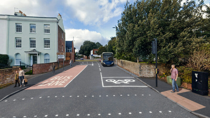
The Exeter Eastern Corridor is approximately 3.4km in length between Pinhoe Sainsburys and the City Centre (Sidwell Street), predominantly along Pinhoe Road (the B3212).
This is a key transport corridor into the city centre serving the suburbs of Whipton, Pinhoe and the eastern urban side of the city. The proposal is to upgrade the route to an ‘Intelligent Corridor’ through system upgrades and installation of various technology solutions.
We are asking for your thoughts on the following proposals through the consultation process:
- Changes to bus lane operation times for:
- Tarbet Avenue to St Marks Avenue, change to Monday to Saturday 7am to 10am (extension of current hours which are Monday to Friday 8am to 9:30am).
- Whipton Community Hall to Widgery Road, change to Monday to Saturday 7am to 10am (extension of current hours which are Monday to Friday 8am to 9:30am).
These upgrades are expected to help decrease bus journey times throughout peak and off-peak hours.
To complement the above proposals, a range of smart technology measures are also planned.
- Adaptive traffic control solutions including using CCTV cameras to monitor both junctions and corridor operations. This is also known as Urban Traffic Control (UTC). This would allow the Council to track how long it takes vehicles to travel through these areas, coordinate traffic signals, and use technology upgrades to give buses priority along a route or corridor. In addition, several traffic corridors will benefit from the Moving Traffic Enforcement policy that is currently awaiting approval from the Department for Transport (DfT). If the policy is approved, Devon County Council will have the power to fine drivers for traffic offences, using the cameras installed along the corridors to help with enforcement.
- Variable Message Signs (VMS) would be improved as a part of the BSIP in the Eastern Bus Corridor Route. These signs would be upgraded to inform drivers about real-time traffic conditions, journey times for the corridor, and congestion data from the UTC system. The aim is to encourage drivers to reroute during busy periods, reducing traffic and congestion on the corridor.
- Improving signal-controlled sites with bus priority technology to extend green signals for buses and decrease waiting times.
- Improvements have already been made to the lighting along this corridor.
Journey Time Benefits:
This scheme aims to improve priority and journey times for buses as well as address road safety difficulties for people walking and cycling on busy routes. For the Exeter Eastern Bus Corridor, there is potential for an approximate four-minute journey time saving per bus, with up to eight services per hour in each direction across four routes. This scheme is intended to help deliver a 27% reduction in bus journey times on this corridor.
Technology measures only AM inbound Approximately 18 seconds per bus AM outbound Minimal impact due to traffic volume / direction PM inbound Minimal impact due to traffic volume / direction PM outbound Approximately 3 minutes 17 seconds per bus - Changes to bus lane operation times for:
-
Honiton Road Active Travel Crossing
Honiton Road Active Travel Crossing
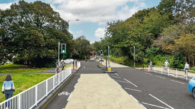
Two active travel crossings will be introduced on the BSIP corridors. The crossings are situated at Polsloe Bridge and at Honiton Road (near Sweetbrier Lane and Rifford Road). The crossings will provide improved pedestrian and cycle crossing facilities and will link up elements of the E12 cycle route, which links Polsloe Bridge to Marsh Barton Station. The soon to be constructed Rifford Road two-way cycle route forms a key part of this route.
For Honiton Road the existing signalised ‘toucan’ crossing on Honiton Road will be changed to a ‘sparrow’ crossing, providing a segregated pedestrian and cycle crossing space. The crossing will have minimal impact on bus journey times because they will operate in the same signal phase as the existing crossing.
The below measures would be implemented to support the crossing upgrade:
- A shared-use pathway, achieved by widening the existing footway to 4.5m. There is potential to impact one tree in an area to the north, which we would mitigate by investigating a no-dig paving solution for this improvement.
- Tactile hazard warning surfaces to be installed at intersections with other existing walkways.
- Existing traffic signal posts to be moved back to align with the new crossing layout.
- New edging to be installed at the back of the proposed widening of the existing footway along Sweetbriar Lane and Honiton Road on either side of the crossing.
- Approximately 1.2m of Stratton Court to be reclaimed for a segregated pedestrian walkway in advance of the proposed sparrow crossing.
This proposal aligns with Local Transport Note 1/20 principles, as set out by central government, treating cycles as vehicles, and separating them from pedestrians at crossings and junctions. The aim is to create a safer and more intuitive route for pedestrians and cyclists through the Honiton Road, Rifford Road and Sweetbriar Lane Junction.
An Artistic Impression of the Proposed Sparrow Crossing on Honiton Road -
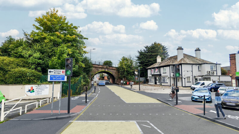
Pinhoe Road Active Travel Crossing Option 1
Pinhoe Road Active Travel Crossing Option 1
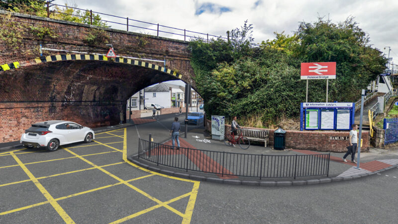
This scheme aims to create a safer and more accessible crossing route for pedestrians and cyclists moving between Hamlin Lane and the path running north-south from The Queens Head pub to Beacon Avenue. The area faces challenges and limitations, mainly due to the narrow carriageway under the bridge. This creates difficulties for all modes of transportation, especially people walking and wheeling, with narrow footways and informal crossings from various locations.
There are currently no crossing facilities provided for cyclists, across Pinhoe Road in the vicinity of Polsloe Bridge. Cyclists either need to dismount and walk to one of the existing pedestrian-only crossings, or cross into the road and cycle with normal traffic through the junction.
There are two options for consideration during the consultation process. This is Option 1.
Option 1 proposes to introduce a toucan crossing that runs diagonally across Pinhoe Road, perpendicular to Polsloe Bridge. This design enables users to navigate both the bridge and the road in a single movement.
We are inviting comments on the following proposal as part of the consultation:
- Installation of a diagonal 3.2m wide toucan crossing on Pinhoe Road.
- New footway construction on Hamlin Lane to create a shared-use space as well as a two-way segregated cycle path connecting to the car park of Hamlin Lane Playing Fields. The shared-use space would avoid potential conflict issues around the Hamlin Lane crossing and would reduce demand on the existing footways under the bridge.
Depending on the consultation outcome, the following measures may need to be implemented to support the chosen scheme:
- Widening of the existing footway into the Queens Head pub car park subject to the purchase of land to create a 3.5m wide shared-use path.
- Realignment of the existing boundary wall in front of The Queens Head pub.
This option would keep people walking, wheeling and cycling on the desired path for the E12 route. It also provides a more comfortable crossing option for people walking or wheeling than using the existing two-stage pedestrian crossing by Beacon Lane.
An Artistic Impression of Pinhoe Road Active Travel Crossing Option 1 -
Pinhoe Road Active Travel Crossing Option 2
Pinhoe Road Active Travel Crossing Option 2
This scheme aims to create a safer and more accessible crossing route for pedestrians and cyclists moving between Hamlin Lane and the path running north-south from The Queens Head pub to Beacon Avenue. The area faces challenges and limitations, mainly due to the narrow carriageway under the bridge. This creates difficulties for all modes of transportation, especially people walking and wheeling, with narrow footways and informal crossings from various locations.
There are currently no crossing facilities provided for cyclists, across Pinhoe Road in the vicinity of Polsloe Bridge. Cyclists either need to dismount and walk to one of the existing pedestrian-only crossings, or cross into the road and cycle with normal traffic through the junction.
There are two options for consideration during the consultation process. This is Option 2.
Option 2 proposes a solution within the road infrastructure to support people cycling along the E12 route by introducing a new toucan crossing east of Polsloe Bridge, and cycle priority access at Hamlin Lane / Pinhoe Road junction.
We are inviting comments on the following proposal as part of the consultation:
- Creation of a new 3.2m wide toucan crossing to assist cyclists crossing Pinhoe Road and accessing the carriageway.
- Widening of the existing footway on the northern and southern sides of Pinhoe Road to provide a 3m wide shared-use path, which could be used by people walking and cycling.
- Footway construction on the south side of Pinhoe Road to provide a space for cyclists to safely transition from the shared path to the carriageway.
The additional additional traffic signals required for the new toucan crossing would be in time with the signals at the Beacon Lane junction, which would ensure minimal impact on the proposed bus improvement schemes. Depending on the consultation outcome, the following measures may need to be implemented to support the chosen scheme:
- Advanced stop line on Pinhoe Road for cyclists travelling westbound. This would help increase driver awareness of cyclists as well as provide a space for cyclists to filter in front of the regular traffic.
- Staggered advanced stop line on Hamlin Lane to allow an early release for cyclists ahead of the traffic. This would enable cyclists to pull away and enter the junction without immediate concerns about other traffic from Hamlin Lane. This would help boost cyclist confidence in using this route as a more accessible option.
An Artistic Impression of Pinhoe Road Active Travel Crossing Option 2. - Tuesday 19 March 2024, 4:30pm – 7:30pm Exeter Guildhall, 203 High Street EX4 3EB
- Thursday 21 March 2024, 10:30am – 2:30pm Exeter Library, Castle Street EX4 3PQ
-
Frequently Asked Questions
Questions
Answers
Why are you consulting on these proposals? We want to give residents and stakeholders the opportunity to meaningfully input into the development of the proposed schemes. We will undertake comprehensive analysis and reporting of the feedback received, including a ‘responses to issues’ section that sets out how the consultation responses are being considered. Consultation responses will help to inform the final scheme designs.
We are conscious that there has been a lot of consultation activity in the area over the last few months, but it is important that all interested parties can shape these proposals for bus and active travel improvements in Exeter. We are consulting on both the bus and active travel schemes at the same time to minimise the risk of consultation fatigue.I’ve heard ‘BSIP’ and ‘LCWIP’ mentioned, what does that mean? In March 2021, the Department for Transport (DfT) announced the National Bus Strategy for England “Bus back better”. It aims to deliver better bus services for passengers through a reform of how bus services are planned and delivered with associated funding. The strategy sets out the requirements for all local transport authorities to publish a Bus Service Improvement Plan (BSIP). BSIPs are intended to be ongoing live documents, that are fully informed by local needs, and which are reviewed at least annually.
Devon County Council’s (DCC) BSIP was first published in October 2021 and outlines the need to deliver bus service improvements including infrastructure enhancements and bus priority measures.
Local Cycling and Walking Infrastructure Plans (LCWIPs), as set out in the Government’s Cycling and Walking Investment Strategy, are a strategic approach to identifying cycling and walking improvements required at a local level. The Exeter Transport Strategy 2020-2030 sets out the ambition for 50% of work trips originating in Exeter to be made on foot or by cycle by 2030. This target received high levels of public support during the Exeter Transport Strategy consultation and was based on a robust evidence base of the extent of change possible, which included development of a bespoke Exeter cycling model.
The Exeter LCWIP sets out the infrastructure measures required to help deliver the modal shift to achieve the 50% Active Travel target.
How are these proposals being funded? To support the Devon BSIP, Devon County Council received funding allocations of £14,057,270 (BSIP allocation 2022 to 2025) with a further £1,677,393 (BSIP+ allocation 2023 to 2024) from the Department for Transport (DfT). There is allocated funding of £1.7M for the Central Corridor and £700K for the Eastern Corridor.
The proposals for the active travel crossings will be subject to further bids for government funding in the future.
What national and local policies do these proposals support? As well as the direct relation to the BSIP & LCWIP, the proposals support the aims of multiple policies including: - Transport Decarbonisation Plan (2021).
- Devon Carbon Plan – the roadmap for how Devon will reach net-zero emissions across a range of sectors including transport.
- Net Zero Exeter 2030 Plan – outlined ambition to be net-zero carbon by 2030.
- Devon & Torbay Local Transport Plan 3 (2011-26) which includes a strategy for Exeter focusing on accommodating new development and growing travel demand.
How will you make this consultation inclusive and accessible? We are publishing information online, holding in person events and making materials available in a range of formats on request. We will provide sufficient information in a range of accessible formats to allow consultees to make an informed response to the consultation. We are hosting all information online and are running two in-person drop-in information sessions, one during the daytime and one in the early evening.
Posters and communication material will include a phone number that people can ring to get help or more information if they don’t have online access.
We will also offer paper / printed versions of the questionnaire on request and accept responses by post and email.How can you be sure that people will hear about the consultation? A stakeholder mapping exercise was completed in advance of the consultation period to identify the key audiences that will be directly contacted about this consultation. Postcards will be dropped to around 6,000 residential and business addresses encompassing a 100m ‘buffer’ along the corridors and around the crossings. We are asking all stakeholders to share social media posts highlighting the consultation and will be putting posters up in community areas and on buses to promote the consultation as widely as possible. What will be the impact of removing the bus stop on Heavitree Road? To facilitate the bus improvement measures on Heavitree Road it will be necessary to remove the bus stop nearest the junction. The location of this bus stop causes a blockage to traffic entering the road when there is a bus parked.
There is another bus stop less than 200m away and we are exploring measures to make this stop more user-friendly, including the possibility of installing a bus shelter.
What are the proposed changes to bus lane operation times? Changes are proposed in 4 areas: - Honiton Road (Hill Barton Road Overbridge to Ringswell Avenue). Change to Monday to Saturday 07:00 to 10:00 (extension of current hours which are Monday to Friday 08:00 to 09:15).
- Tarbet Avenue to St Marks Avenue. Change to Monday to Saturday 07:00 to 10:00 (extension of current hours which are Monday to Friday 08:00 to 9:30).
- Whipton Community Hall to Widgery Road. Change to Monday to Saturday 07:00 to 10:00 (extension of current hours which are Monday to Friday 08:00 to 9:30).
- Two options for Fore Street between Butts Road and Church Street (extension of current hours which are Monday to Friday 08:00 to 09:30 and 16:00 to 18:30):
- Option 1: Monday to Saturday 07:00 to 10:00 and 15:00 to 19:00
- Option 2: Monday to Saturday 07:00 to 19:00
The Fore Street / North Street junction is a pinch point. Will these proposals help to improve that? This junction has been modelled as part of the project; any improvement measures are heavily constrained due to lack of available space. Dependent on the outcome of the consultation, there are some supplementary proposals that could improve traffic flow at the junction for all users. However, these measures may result in a reduction in parking in North Street. What does hierarchy of usage mean and what does this mean for private car users? This is where walkers, cyclists and buses are given priority over the private car at junctions and light controlled signals and crossings. Whilst it is impossible to prioritise everyone, our modelling shows that improved flow through traffic for buses, is also likely to have a knock-on positive effect on traffic flow for all road users, including those in private cars.
The active travel crossings that are proposed would be synced with nearby signals and traffic control measures to ensure that there is no disbenefit to bus journey times.
How will you enforce bus lane use? Several traffic corridors will benefit from the Moving Traffic Enforcement policy that is currently awaiting approval from the Department for Transport (DfT). ANPR cameras will be put along the routes, and if the policy is approved, Devon County Council will have the power to fine drivers for traffic offences. It is hoped that these powers will be granted to the Council in Spring 2024. More details on Moving Traffic Enforcement in Devon can be found here: Moving Traffic Enforcement – Roads and transport (devon.gov.uk) Will these proposals result in a loss of parking? If implemented, some of these proposals would result in a loss of time limited and / or residential permit parking. At Livery Dole, the pre-signals intervention would result in a loss of 30m on-street parking length (approx. 5 bays at 6m long each), which are residents permit holders only spaces.
Depending on the outcome of the consultation and the proposals that are taken forward, there are two further potential interventions that may affect parking bays; these are the extension of the right turn lane on North Street (loss of 2.no bays) and the relocation of the loading bay on Fore Street (loss of 3.no bays).
It is not possible to implement these bus improvement measures without impacting parking availability.
Has the Active Streets trial impacted the data that informed these proposals? Data was collected in March 2023, before the Active Streets trial came into effect. If you have specific feedback on the Active Streets project, please provide feedback here. When will these improvements happen? The proposed bus corridor improvements will be funded from the DfT allocation that has already been made to the Council to deliver BSIP projects. Measures must be in place by March 2025.
The active travel improvements are for consultation only at this stage and their implementation will be subject to successful funding bids in the future.
What else are you doing to improve the experience of bus users in Exeter? We are investigating improvements to bus stop infrastructure throughout the area, including real time information and shelter improvements. We have also already undertaken works to improve the lighting around bus stops where possible. We may also renew road markings to make lines and bus lanes more visible and are considering whether bus lanes should have a different coloured surface to make them more easily distinguishable from the main carriageway. Will taxis and private hire vehicles be able to use the bus lanes? Yes, vehicles with the correct licensing and sticker (issued by Exeter City Council as the licensing authority) will be able to use the bus lanes as they do at the moment. The exception to this is the City Centre and New North Road, which will remain for bus use only. Why are you only looking at these areas in Exeter? The Bus Service Improvement Plan (BSIP) covers the whole of Devon. It identified four bus corridors within Exeter that would benefit from work to improve bus reliability. The Northern (New North Road) and Western (Cowick and Preston Street) corridors were consulted on in 2023.
The Local Cycling and Walking Plan (LCWIP) identified 22 cycle routes and 5 walking zones across Devon. The crossings that we are consulting on affect one of the cycle routes, the E12.
To view the technical drawings and artistic impressions more clearly, please go to the Supporting Documents section below.
Have your say
The consultation period is open until noon Friday 29 March 2024. To provide your feedback, please click here to complete an online survey (This consultation is now closed).
You may also like to attend one of our public drop-in events where you can find out more about the proposals and speak to members of the project team. There is no need to book for these events, just turn up:
To request any of the consultation materials in different formats (including paper copies) please email transportplanning@devon.gov.uk. Alternatively you can write to us or phone. Please find the contact information section below.
Frequently Asked Questions
What Happens Next?
Once this consultation closes on Friday 29 March 2024, the project team will produce a report outlining the feedback received from members of the public and stakeholders. This report will help inform future stages of the project, with the BSIP proposals set to complete their design phase by Summer 2024.
The BSIP schemes are funded by the Department for Transport and must be developed by March 2025. The active travel crossings only have design funding at present, therefore progression will be subject to future external funding opportunities.
Supporting Documents
- Overview Map
- Technical Drawings of Proposals
- Artistic Impressions
- Consultation Presentation
- Consultation Poster
- If you would like to read through the survey questions before completing them online, please click here.
Accessibility
We take accessibility seriously and recognise that some of the information presented in the files available on this page may not be fully accessible to someone using assistive technology such as a screen reader.
If you need guidance or an alternative format, email transportplanning@devon.gov.uk with details of any preferred format and the assistive technology you use.
Contact Information
Post: Devon County Council, Transport Planning, Room 120, County Hall, Topsham Road, Exeter, EX2 4QD
Email: transportplanning@devon.gov.uk
Phone: 0345 155 1004