Last Updated: 2023 / 12 / 05
The Public Consultation is now closed. The Public Consultation Report is now available.
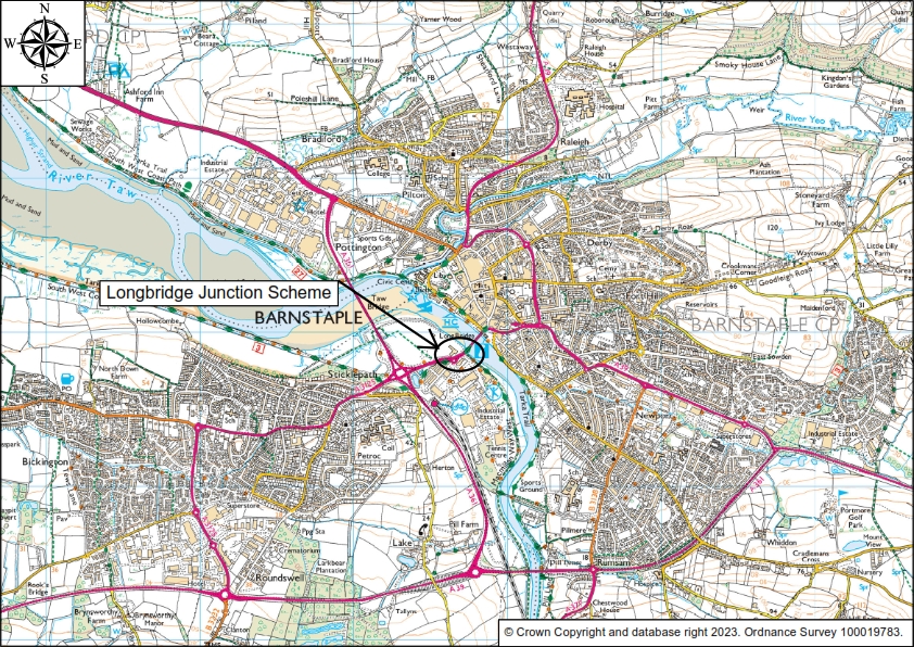
You were invited to have your say via a questionnaire on proposals for changes to the Longbridge Junction in Barnstaple that will see; traffic lights removed; improved crossings for people walking, wheeling and cycling; and changes to the Station Road (Halfords) roundabout. Alternatively, it was possible to contact the team via the contact details provided at the bottom of the page. In addition, paper copies of the below information and questionnaire were also available at Barnstaple Library at reception.
-
Aim
The proposal aims to:
- Provide a better entrance to Barnstaple, England’s oldest Borough, for people coming into the town from the west side of the river, from the Tarka Trail, railway station or main historic road approach to the town.
- Modernise the junction arrangement for future traffic levels, including changes to the lane markings and lane allocations on the roundabout.
- Make the Longbridge Junction a pleasant area for people to be and travel through.
- Build infrastructure previously consulted on in principle through the Local Cycling and Walking Infrastructure Plan.
- Fit with North Devon Council’s Vision for Barnstaple.
- Avoid the need to replace old traffic lights equipment.

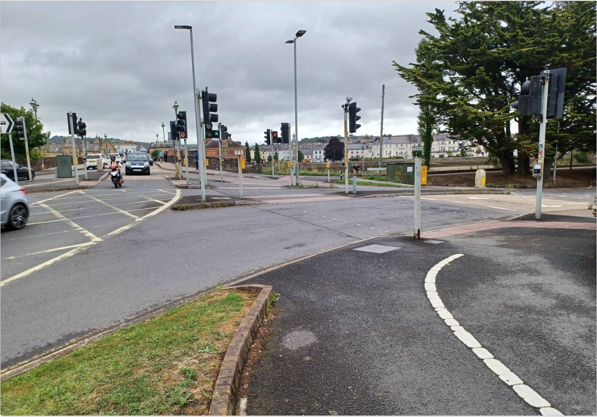
Image showing current view of the Longbridge on approach to Barnstaple Town Centre. 
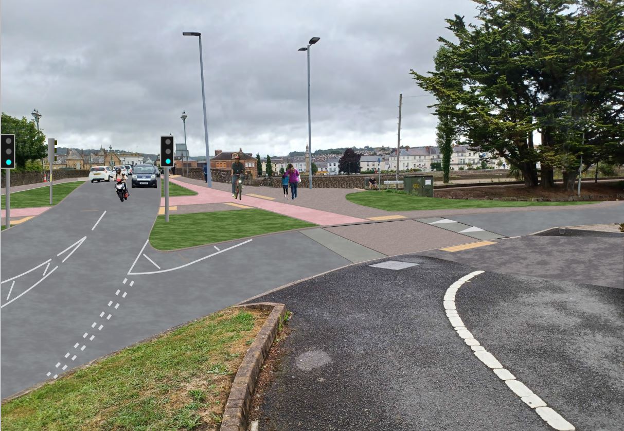
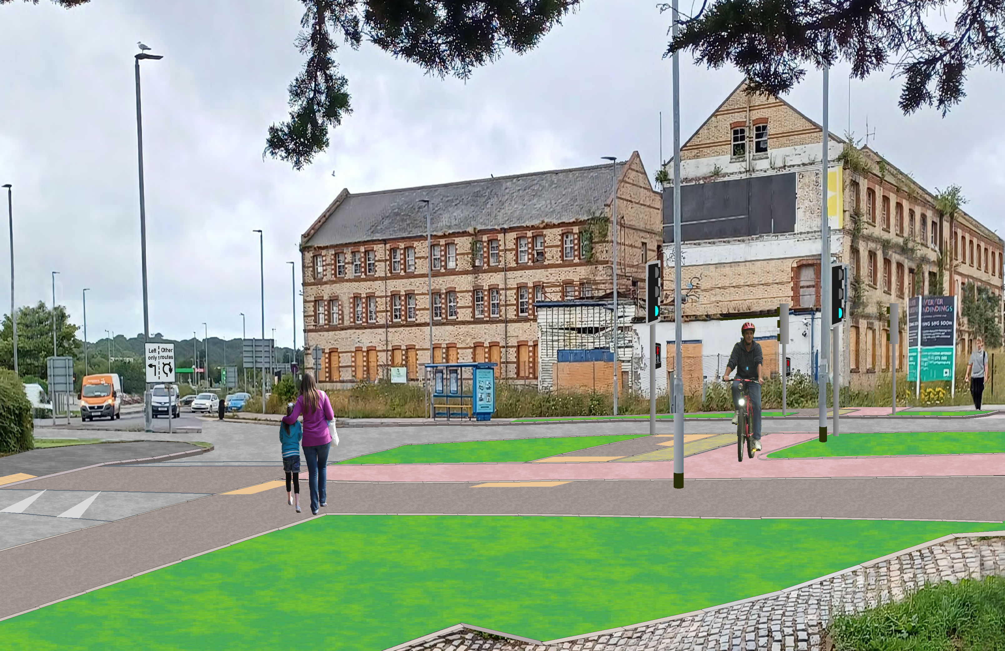
Image showing artist’s impression of what this view of the Longbridge on this approach to town might look like with the proposed scheme. -
Background
The existing junction arrangements require the use of multiple road crossings for people to cross (see picture below). The traffic lights provided at these crossings are beyond their design life, evident from the level of rusty metal poles at the junction. These traffic lights use tungsten halogen lamps, the manufacturing of which is environmentally damaging, and will soon be withdrawn from use, so the site needs to be upgraded to LED lights. There is therefore a requirement to replace all of the equipment at this junction, or instead carry out a major change.

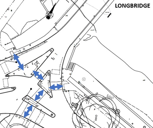
Plan showing current arrangement of multiple crossings of road. Transport makes up 30% of Devon’s greenhouse gas emissions and improved infrastructure for people to walk, wheel and cycle will allow more people to make short urban trips without a car – a government target for 2030 being 50% of such short urban trips made by walking, wheeling or cycling.
Barnstaple’s Longbridge is one of the busiest links for people walking, wheeling and cycling in northern Devon, as well as being an historic major A class road with significant levels of vehicle traffic. All people travelling in the area have to use the Longbridge Junction in some way regardless of their origin or destination.
Towards Town Centre Total Peak Hour Traffic Peak Hour Pedestrians 2520 290 4pm to 5pm Cycles 280 50 8am to 9am Vehicles 8700 890 5pm to 6pm Towards SBB Total Peak Hour Traffic Peak Hour Pedestrians 2390 270 3pm to 4pm Cycles 310 50 3pm to 4pm Vehicles 7540 760 4pm to 5pm and 5pm to 6pm The Longbridge Junction also serves other paths as described below and therefore sees more people using it than the figures above. This junction is the intersection for five key routes:
- To the north is the new path alongside the river through the Anchorwood Bank housing development and onto the Tarka Trail.
- To the south is the path to the leisure centre and onto the Iron Bridge. Part of the National cycle Network route 3 (NCN3).
- To the west are two links to the train station and up the hill towards ASDA. One link goes between Halfords and the Barnstaple Retail Park car park (the official route of NCN3), another on the roundabout side of Halfords – both go onwards to the train station and link to the recently built parallel crossing (zebra crossing for pedestrians and cyclists).
- To the east is the link to the town centre over the Longbridge. This is one of the busiest walking and cycling routes in the area, but constrained by the width of the bridge. The footways are 1.8m at their narrowest (in the middle of the bridge) and cyclists have to use the carriageway with a large volume of vehicles. This is part of the NCN3 route and official link to NCN27 (Tarka Trail to Braunton).
Improved links for people walking, wheeling and cycling across the river Taw, via the Longbridge, would meet the future needs of local residents by connecting an area (Town Centre) classified as amongst the lowest indices of multiple deprivation with the train station, college and employment areas with improved walking and cycling links. This fits with Devon County Council’s strategic ambitions to keep Devon’s resident’s healthy and safe and help reduce carbon emissions.
-
Proposed Scheme
It is proposed to alter the existing highway layout in the following ways:
- New and improved segregated walking, wheeling and cycling paths and areas of shared use paths connecting multiple existing paths together.
- Removal of all traffic lights and replacement with a priority junction and one new signalised crossing of the main road for people walking, wheeling and cycling.
- Changes to the road layout and removing vehicles turning left from the Longbridge to Seven Brethren Bank.
- Changes to the road layout and removing vehicles turning right from the A3125 into Seven Brethren Bank.
- Narrowing of Seven Brethren Bank on pedestrian and cyclist desire lines and building a raised table crossing.
- Changes to the markings and layout of the Station Road roundabout so that on the approach from the Longbridge vehicles in the left lane will turn left only, and the right hand lane will be for vehicles straight ahead (to Sticklepath Terrace), ahead/slight right (towards Sticklepath) and U-turn (towards town centre).
- A new formal crossing of Station Road near the Roundabout (not show on the plan).
Image showing artist’s impression of what this view of the Longbridge on this approach to town might look like with the proposed scheme. The artist’s impression is available with Before and After images of what the scheme could include (zoom out to fit image on one page, then move the slider left and right to see the difference between the existing and proposed plans).

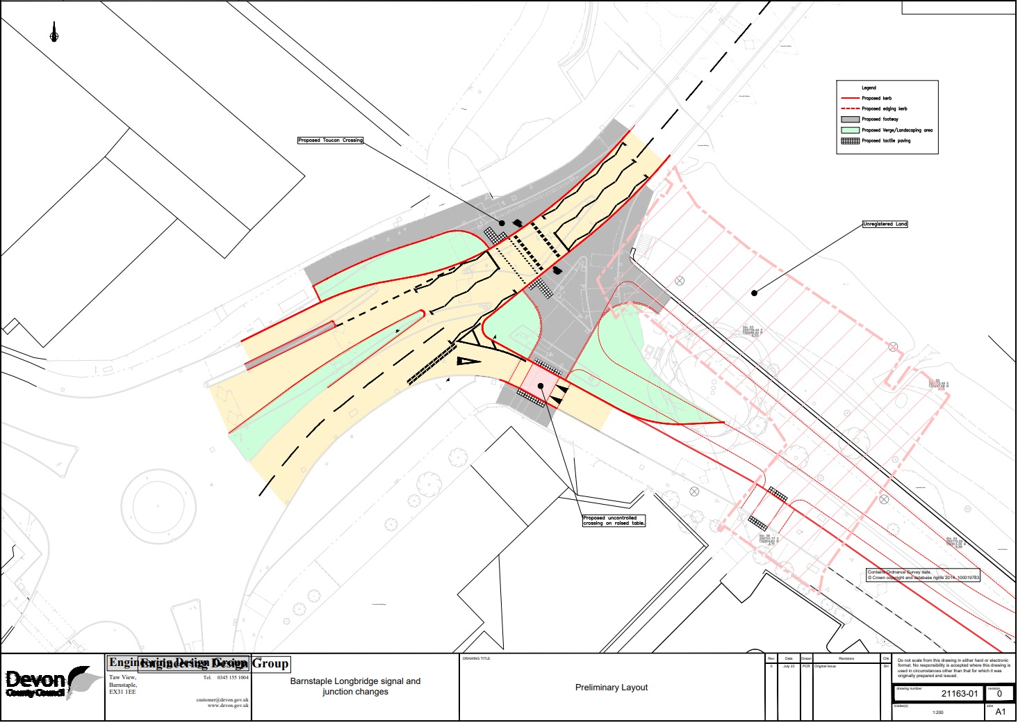
Image showing artist’s impression of what the proposed junction might look like from the Seven Brethren Bank approach, with proposed lane allocation signage at the roundabout. The preliminary layout design is also available below, or click on link for the detailed design.

Image showing preliminary layout design. The scheme directly fits into challenges two through six of The Vision for Barnstaple:
- To make Barnstaple more attractive to residents and visitors by revitalising and diversifying the town centre economy.
- To restore, reuse and celebrate Barnstaple’s historic buildings and townscapes.
- To put people first by encouraging walking and cycling and reducing the negative impact of traffic and parking.
- To reconnect the town to the River Taw.
- To establish a complementary relationship between the historic core and the retail parks on the south bank of the river.
- To ensure that the regeneration of Barnstaple town centre contributes to the Devon Climate Declaration.
It is supported by the Local Walking and Cycling Infrastructure Plan, and is part of the ‘Roundswell to Pilton’ route which received 84% support through public consultation.
-
Cost
It is expected that the scheme will cost approximately £500,000, subject to the cost of needing to move any utilities in the road which can be very expensive. This cost is expected to be met from money already received from the nearby Anchorwood Bank development including ASDA, the new retail park and Taw Wharf housing. -
Alternative
The alternative to this scheme is to replace the existing traffic lights with new equipment including LED bulbs and new aluminium poles at an expected cost of approximately £75,000. This would have to be funded from the already overstretched highway maintenance budget. It would not be possible to use money from the nearby development at Anchorwood Bank to pay for this, as it is considered routine maintenance. -
Traffic Data and Modelling
Modelling
Detailed traffic modelling has been undertaken using modelling originally made for the upcoming housing development of the old Leisure Centre. Based on traffic data in 2019 before the COVID-19 pandemic, predictions have been made for the level of vehicle traffic and the journey time through the Longbridge Junction in 2024 and 2031 with and without the scheme.
No modelling has been carried out for people walking, wheeling or cycling as this is much harder to predict at specific individual junctions than vehicle traffic.
Traffic modelling includes the addition of traffic after the construction of housing at the old Leisure Centre site.
Impact of Banning Turns into Seven Brethren Bank
It is proposed that the vehicular left turn from the Longbridge to Seven Brethren Bank and the right turn from the A3125 into Seven Brethren Bank are both removed to provide more space for walking, wheeling and cycling. This means vehicles will have to find an alternative route into Seven Brethren Bank, such as via Station Road.
The table below shows the traffic turning onto Seven Brethren Bank from a count carried out in 2019 for the morning and evening peak hours, as well as the predicted traffic that could carry out the movement in the 2024 and 2031 future scenarios if the proposal doesn’t go ahead.
Time Period Movement 2019 (count) 2024 (Predicted) 2031 (Predicted) 8-9 AM From Longbridge to Seven Brethren Bank 60 80 110 8-9 AM From A3125 to Seven Brethren Bank 100 90 70 5-6 PM From Longbridge to Seven Brethren Bank 40 80 70 5-6 PM From A3125 to Seven Brethren Bank 70 60 90 The traffic turning into Seven Brethren Bank is less than 10% of the total 2019 traffic passing through the junction in both time periods. This traffic will redirect onto Station Road, switch modes or make alternative journeys.
Impact on Journey Time
Impact of the scheme proposal was measured by changes in vehicular traffic and journey time between three different locations markers on the road network, specifically on the Longbridge, at Station Road near Tesco and the A3125 up hill from the ASDA junction. Routes between these locations all go through the affected roundabout in front of Halfords.
Morning peak time travel
Modelling results predict that with the scheme there will be a slight benefit to journey time for some vehicles and a slight negative impact to others.
At this time of day the same amount of traffic is predicted to get through the roundabout as the present time and the biggest journey time variation is that it is predicted to take, on average, 18 more seconds to get from Station Road (Tesco) to the Sticklepath Junction (Squareabout).
There is also predicted to be an average 17 second reduction in vehicle traffic journey time for vehicles travelling from the Longbridge to Station Road (Tesco) if the proposal is built in the year 2031 compared to not building the proposal.
This means that travel by vehicle towards the train station will be slightly quicker on average if the proposal is built.
Evening peak time travel
Modelling results predict that with the scheme vehicle traffic from the Longbridge to Station Road (Tesco) will benefit in terms of journey time, but leaving Station Road will take longer.
From the Longbridge to Station Road (Tesco) journey time is predicted to improve by 30 seconds on average with the proposal (in both 2024 and 2031).
However, from Station Road journey times are predicted to get worse if people choose to travel in the same way and at the same time as they currently do.
In 2024 and 2031, it is predicted that capacity from Station Road will lower by 30 to 50 vehicles and journey times might increase by up to three and a half minutes.
The existing situation on Station Road in the evening peak travel time can be very congested. The proposed scheme will not alleviate this, and it may get marginally worse. However, the proposal keeps the exit from Seven Brethren Bank onto the main A3125, so there would still be an alternative route for vehicles to leave Seven Brethren.
Benefits to People Travelling Actively
A pedestrian and cycle count that was carried out on the Longbridge on a ‘neutral day’ Thursday 13th October 2022, and can be seen in the ‘background’ section above.
This shows that based on the 2022 count, at least 560 pedestrians and 100 cyclists would benefit from the simplified junction proposals in peak hours. This does not include people using the junction without going over the Longbridge, such as those travelling north-south on the western side of the river.
Additionally, there are many approved housing developments and future allocated sites for further development to come forward in the coming years, meaning more people will be looking to travel into and around Barnstaple. Some roads are at capacity at some parts of the day. This means more people will have to make a mode shift to walk, wheel or cycle where possible, and the proposed scheme is designed to help more people travel without a car if they are able to.
The proposal would also segregate people walking from people cycling at this busy junction, reducing conflict between these users.
With the removal of traffic lights and widening of the paths to cater for desire lines and reduce the number of road crossings; it will be easier for people to cross; everyone will feel more welcome and included; and it is hoped people will choose to walk and cycle more as it will be a more pleasant environment. People should feel safer as there are fewer conflicts with vehicles. The existing trees will remain and provide some shade and shelter and it might be possible to include benches for people to stop and rest. The scheme encourages more people to safely walk, wheel and cycle, living a healthier lifestyle by exercising outside. The proposals will be designed to help create ‘Healthy Streets’.
Modelling limitations
The model represents traveling conditions in the peak hours. This means it represents the worst case scenario within the day, not the average. Outside of the peak hours the delay to journey times would not be this severe, and would likely result in a benefit to all road users in terms of journey times due to the removal of traffic lights and the need for vehicles to wait at a red light.
The impacts for this scheme were only measured through changes to the journey time and number of vehicles traveling between the defined markers. There could be other benefits and disbenefits not assessed including but not limited to environmental impacts such as air quality and social and economic considerations.
It is extremely difficult to correctly model human behaviour, especially when it comes to congested networks where drivers act differently than in free flowing traffic. For example, it’s not possible to model drivers who give way to others out of courtesy, or make manoeuvres to squeeze others in, or change their mind about their destination, or simply make a u-turn if the queue infront of them is too long and they know faster alternative routes.
-
Barnstaple Longbridge
History
A timber bridge has been documented here since the year 1304. This was largely replaced by stone gothic arches in 1473, apart from three arches on the town side which were replaced in 1589.
In 1796 the bridge was widened with the recesses over the cutwaters removed by constructing segmental arches between the cutwaters.
It was widened again in 1832 and 1834 with 1.2m wide footways being installed – supported on cantilevered cast-ironwork.
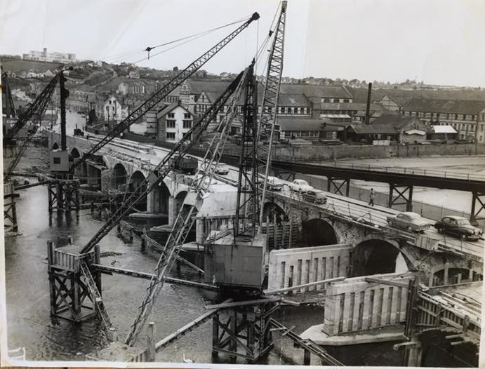
Then in 1963 the cast iron work was removed and the bridge widened yet again with concrete faced with masonry on the upstream side.

Photo from Devon County Council archives taken during these works. The single carriageway is now 7.3m wide with 1.8m wide footpath on both the upstream and downstream sides. The carriageway and footpath widths vary at the ends of the bridge to tie into the roads that approach it. There is currently no weight restriction over the bridge.
Barnstaple Longbridge has been Grade 1 listed since 19th January 1951.
There is much information available about the history of the Longbridge and Barnstaple. One such book is Barnstaple, 1640-1607 Richard Newcourt’s Map edited by Todd Gray and including a chapter on the Longbridge by David Harrison and Bill Harvey.
Future Aspirations
Thinking about the future of the Longbridge, Devon County Council would like to improve existing conditions to cater for increased volumes of people walking, wheeling and cycling. A number of ideas were provided within the questionnaire for the public to provide their views on.
The proposed scheme at Longbridge Junction would fit well with the possible widening of the bridge on the upstream side, extending the widening carried out in the 1960s. Detailed investigations and designs to widen the bridge would need to be carried out, and would take over a year. This would not remove vehicles from using the bridge in either direction, it would only add additional space for people to walk, wheel and cycle off road.
Email: transportplanning@devon.gov.uk
Phone: 03451551004